Third Rifle Elk Plan
One camp on water at 9,590 ft, 3 morning and 3 evening seats within 0.74 mi of the tent, and 3 midday spots. Every pin is on USFS land. Tap any coordinate to copy it into your map app.
The plan
Leave the truck on Gold Camp Road CR 8. Walk 1.77 mi (+639 ft, about 91 min) to camp at 9,590 ft. Water is 84 m away: sure water.
The strongest reasons this area ranked first: it is a long way from roads open to vehicles; the ground is steep enough to give animals a refuge; there is timber for animals to hold in during the day. Target elevation band for this season: 8,400-9,900 ft.
Each sit watches a named piece of feed from edge cover. Leave times below put you in a morning seat 45 minutes before legal light and an evening seat 2 hours before dark. Check the wind at every sit and switch seats if it is wrong.
Truck to camp up to 2 mi and +1,000 ft. Camp to a sit up to 1 mi and +700 ft. Camp water rule: likely. 1 hunter with a tag.
Map
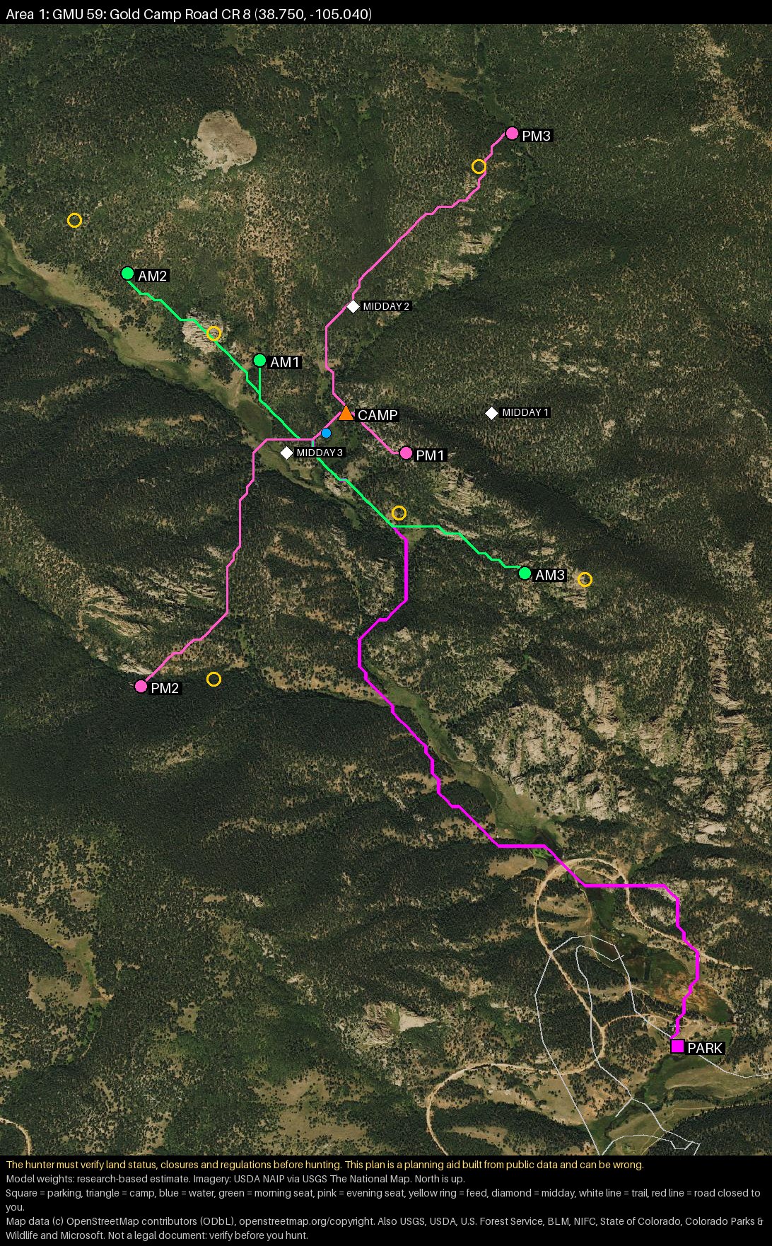
Base camp
Tap a coordinate to copy it into your map app.
| Pin | Coordinates | Elevation | Land | Notes |
|---|---|---|---|---|
| Park | 9,385 ft | USFS | Legal public road: Gold Camp Road CR 8. Park fully off the road, never on dry grass. | |
| Camp | 9,590 ft | USFS | backcountry camp. Pitch at least 100 ft from the water. From the truck: 1.77 mi, +639 ft (about 91 min). | |
| Water | 9,574 ft | USFS | sure water: perennial stream with a large catchment. Catchment about 10 km2. 84 m from camp. Filter all water. |
Drive from your start point: about 1.49 h. Walk in: 1.77 mi, +639 ft, -434 ft.
Seats
Legal light on Sat, Nov 7 at this spot is about 6:03 AM to 5:24 PM, and about 6:12 AM to 5:17 PM on Sun, Nov 15. Confirm exact times before you go.
| Seat | Use | Seat coordinates | Feed coordinates | From camp | Walk | Leave camp | Shot | Feed elev. | Wind |
|---|---|---|---|---|---|---|---|---|---|
| AM1 | Morning | 0.29 mi, +29 ft | ~10 min | 5:08 AM | 176 yd | 9,597 ft | Morning air drains downhill, away from the feed. Bad wind: from the SE (it blows your scent onto the feed). | ||
| AM2 | Morning | 0.58 mi, +86 ft | ~23 min | 4:55 AM | 247 yd | 9,663 ft | Morning air drains downhill, away from the feed. Bad wind: from the SE (it blows your scent onto the feed). | ||
| AM3 | Morning | 0.6 mi, +537 ft | ~50 min | 4:28 AM | 198 yd | 10,092 ft | Morning air drains downhill, away from the feed. Bad wind: from the W (it blows your scent onto the feed). | ||
| PM1 | Evening | 0.14 mi, +122 ft | ~12 min | 3:12 PM | 198 yd | 9,524 ft | Evening air rises, away from the feed, until the slope goes into shade. Bad wind: from the N (it blows your scent onto the feed). | ||
| PM2 | Evening | 0.74 mi, +384 ft | ~45 min | 2:39 PM | 241 yd | 9,614 ft | Evening air rises, away from the feed, until the slope goes into shade. Bad wind: from the W (it blows your scent onto the feed). | ||
| PM3 | Evening | 0.72 mi, +564 ft | ~55 min | 2:29 PM | 155 yd | 10,050 ft | Evening air rises, away from the feed, until the slope goes into shade. Bad wind: from the NE (it blows your scent onto the feed). |
Leave times are for Sat, Nov 7 and shift a minute or two each day.
Midday
| Spot | Coordinates | Elevation | Notes |
|---|---|---|---|
| M1 | 9,828 ft | Still-hunt the edge of this bedding timber slowly, into the wind, at midday only. Do not walk through the middle. Patch about 3.8 ha, 1729 yd from the nearest road or trail. | |
| M2 | 9,680 ft | Still-hunt the edge of this bedding timber slowly, into the wind, at midday only. Do not walk through the middle. Patch about 8.2 ha, 1692 yd from the nearest road or trail. | |
| M3 | 9,589 ft | Still-hunt the edge of this bedding timber slowly, into the wind, at midday only. Do not walk through the middle. Patch about 13.8 ha, 1441 yd from the nearest road or trail. |
Why this area
- It is a long way from roads open to vehicles.
- The ground is steep enough to give animals a refuge.
- There is timber for animals to hold in during the day.
The ranking is a research-based estimate, not a prediction.
The unit last year
These are Colorado Parks and Wildlife survey estimates for the whole unit. Success on public land is usually lower than the unit figure. They are not a prediction for this plan.
What was checked, and what was not
- Every pin on this page is marked verified on land open to public hunting: USFS.
- Drive-in route checked inside the unit against roads tagged or listed private: none used. Gates, closures and the roads outside the unit are not checked.
- Ownership checked with: BLM Surface Management Agency identify service (online) + CPW properties.
- County parcel records were not checked here (the parcel service did not answer): land status rests on the BLM map and CPW data alone.
Rules on the ground
- Legal hunting hours are one-half hour before sunrise to one-half hour after sunset.
- With a rifle license: at least 500 square inches of solid fluorescent orange or pink, plus an orange or pink hat visible from all angles.
- Legal bull in this unit: four points or more on one antler, or a brow tine at least 5 inches long.
- Over-the-counter bull elk licence (unlimited).
- Leave evidence of sex naturally attached to the carcass, and attach the carcass tag before you move it.
- Never shoot across a road or trail. Know what is behind the animal.
From the CPW 2026 Big Game Brochure. Read the brochure for your own hunt code; rules change.
Notes from the planner
- Only 1 area is offered. 2 weaker candidates were left out, not used to fill the list.202), or under the minimum of 0.03.
Before you go
- Call the ranger district for this area: is the road to the parking spot open on your dates, and is dispersed camping allowed where the camp pin sits?
- Check for fire restrictions and closure orders the day before you leave.
- Import the KML or GPX into your map app and download offline maps for GMU 59.
- Save each walking route as a track. You will follow them down in the dark.
- Check the snow and the forecast the week before, and again two days before.
- Confirm sunrise and sunset for your dates, and be honest about your walking limits.
You must verify before you hunt. The hunter must verify land status, closures and regulations before hunting. This plan is a planning aid built from public data and can be wrong. If a sign, fence, gate, order or regulation disagrees with this plan, the plan is wrong.
Map data (c) OpenStreetMap contributors (ODbL), openstreetmap.org/copyright. Also USGS, USDA, U.S. Forest Service, BLM, NIFC, State of Colorado, Colorado Parks & Wildlife and Microsoft. Not a legal document: verify before you hunt. Data accessed 2026-10-01. Plan 6c2b6632b37b.