Colorado rifle elk and mule deer · fall 2026
You have the tag. Here is where to park, camp and sit.
Tell us your tag and where you drive from. You get one exact plan: a legal place to leave the truck, a camp near water, morning and evening spots that watch feed, and the walk between them. It loads into the map app you already use.
Get a free plan for your tag See a real plan
Free for the first 25 hunters this season. In return, tell us after your hunt what was right and what was wrong.
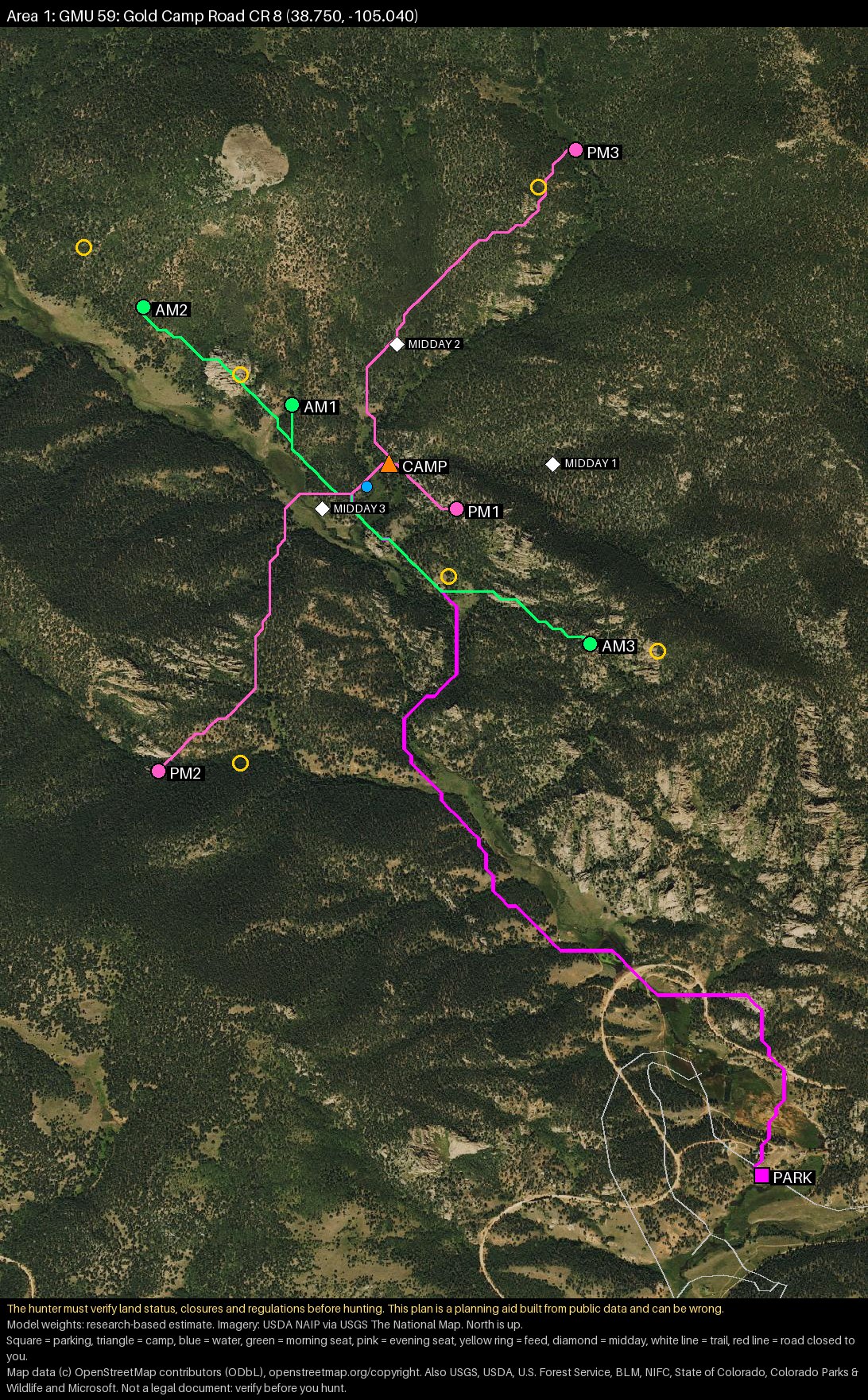 Real plan · GMU 59 · 3rd rifle elk
Counts from the sample plan, GMU 59, 3rd rifle elk. Yours is built for your tag, your start point and your limits.
Opening morning, already worked out
Most hunters spend the first two days of a five-day season finding out where to be. This is opening day from the sample plan, taken straight off the page.
Leave the tent
Seat AM2 is 0.58 miles and 86 feet of climb from camp, about 23 minutes in the dark. The route is in your map app as a track.
Sit down, 45 minutes early
You are in edge cover at , looking at a named piece of feed 247 yards out.
Legal light
Morning air drains downhill, away from the feed. If the wind is from the south-east, this seat is wrong, and the plan says so. Two other morning seats are waiting.
Three patches of bedding timber
Each is nearly a mile from any road or trail. Work the edge slowly, into the wind. Do not walk through the middle.
Leave for the evening seat
PM2 is 0.74 miles and 384 feet up, about 45 minutes. You are seated two hours before dark with a 241-yard shot.
End of legal light
Follow the saved track back to a tent that is 84 metres from a year-round stream.
Every seat, to the yard
Not a zone to go look around in. Coordinates you tap to copy, the time to leave camp, the shot, and the wind that ruins it. These are all six seats from the sample plan.
| Seat | Use | Coordinates | From camp | Leave camp | Shot | Bad wind |
|---|---|---|---|---|---|---|
| AM1 | Morning | 0.29 mi, +29 ft | 5:08 AM | 176 yd | SE | |
| AM2 | Morning | 0.58 mi, +86 ft | 4:55 AM | 247 yd | SE | |
| AM3 | Morning | 0.6 mi, +537 ft | 4:28 AM | 198 yd | W | |
| PM1 | Evening | 0.14 mi, +122 ft | 3:12 PM | 198 yd | N | |
| PM2 | Evening | 0.74 mi, +384 ft | 2:39 PM | 241 yd | W | |
| PM3 | Evening | 0.72 mi, +564 ft | 2:29 PM | 155 yd | NE |
Leave times are for Saturday 7 November 2026 at this spot. The plan also gives the coordinates of the feed each seat watches.
Everything in the plan
Parking, camp and water
A legal place to leave the truck, a tent site off the road, and water close by, rated by how sure it is. You choose how sure it has to be.
Morning and evening sits
Each one watches a named piece of feed from cover, with the shot distance, the leave time and the wind that makes it wrong.
Where to go at noon
Bedding timber far from roads, and how to hunt its edge without blowing it out.
Every walk, measured
Truck to camp and camp to each seat, inside the miles and climb you said you can do.
Why this ground
The reasons this area beat the rest of the unit, in plain words.
Your unit last year
Hunters, animals taken, success and days hunted in your season, from state estimates.
Rules for your tag
Legal hours, orange, the antler rule for your unit, and tagging, from this year's state brochure.
What was checked, and what was not
The land records each pin was tested against, and a plain list of what nobody checked, so you know what to confirm.
For your map app
KML and GPX with every pin and route, an aerial map, and a page you can print for the truck.
A map shows you the ground. This tells you what to do on it.
- Shows who owns each parcel
- Shows roads and trails
- Leaves the scouting, the camp and the seats to you
- Same for every hunter
- Knows the ground
- Costs thousands of dollars
- Hunts where they have a permit, on their dates
- Not what a do-it-yourself hunter wants
- Uses the map app you already have
- Picks the truck spot, camp and seats for you
- Fits your tag, your dates, your legs and your rifle
- Says what it checked and what it did not
Every pin is checked
- Each pin and each route is checked against public land ownership records. Anything not public is dropped.
- Roads are checked against Forest Service motor vehicle rules. Closed, private and gated roads are not used.
- Camps are kept off roads and trails and the right distance back from water.
- If we cannot find a legal plan that fits your limits, we say so. We do not loosen the rules to fill the page.
You still have to confirm land status, closures and regulations yourself before you hunt. Records can be wrong or out of date.
Look up your unit
In 2024, an estimated 121,786 rifle elk hunters hunted Colorado and 23% filled a tag. See how your unit compares: hunters, harvest and crowding by season.
From Colorado Parks and Wildlife harvest estimates. All units
How it works
- 1
Fill in the form
Your tag, your dates, where you drive from, and how far you will walk.
- 2
We check your unit
We reply within two days to say whether your unit is ready.
- 3
You get the plan
The plan and the map files arrive by email before you leave.
- 4
You report back
After the hunt you answer eight short questions. That is the whole price this season.
What this is, honestly
- It is new. This is its first season and it has not been proven in the field yet. That is why it is free and why we are asking for your report.
- It plans from public data: land ownership, roads, terrain, tree cover, water and season rules. It does not track animals and does not know where they are today.
- It does not promise an animal. It promises a legal, specific plan built for your tag and your limits.
- This fall it covers Colorado rifle seasons for elk and mule deer. Units are being added through October, so yours may not be ready. We will tell you either way.
Get a free plan for your tag
About two minutes. No account, no card. Everything the plan is built from is on this form, so there is no back and forth.
We use your answers only to build and send your plan and to ask for your report. See the privacy page and terms.