Alaska Game Management Unit 25: subunits, harvest and draw hunts
Unit 25 covers 53,220 square miles in 4 subunits, 25A, 25B, 25C and 25D, by ADF&G's boundary file. ADF&G's interim harvest report counts 1,290 caribou hunters in the unit in 2025, 587 of them successful (46%), counting hunters who did not name a subunit. 76% of the unit is federal land in USGS PAD-US. 1 drawing hunt reaches into it.
Data updated October 2026. Harvest: ADF&G interim harvest reports, 2020 to 2025. Drawing: ADF&G's 2025 results. Land: USGS PAD-US 4.1.
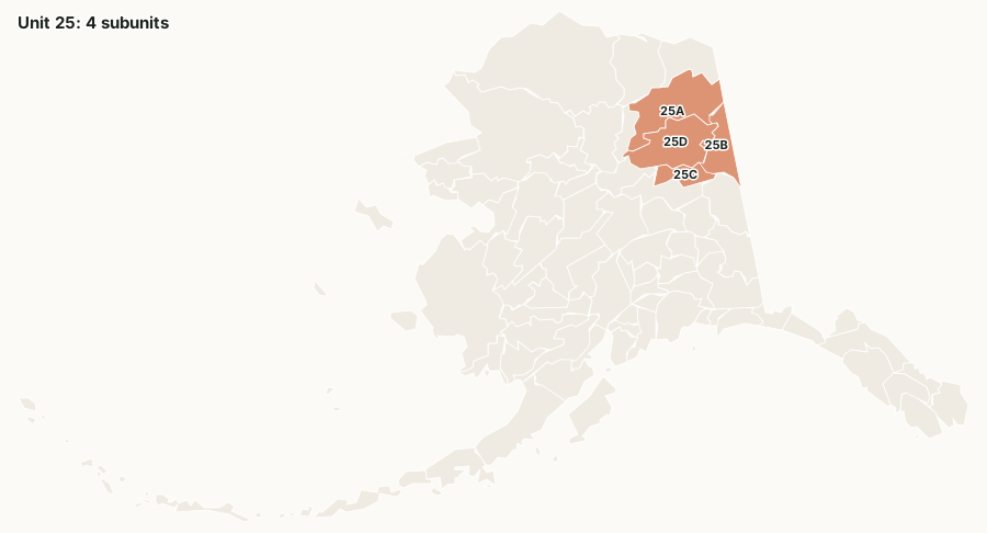
How do the subunits of Unit 25 compare?
2025 regulatory year, successful hunters over all hunters, by ADF&G's interim harvest report:
| Subunit | Square miles | Caribou | Moose | Dall sheep | Federal land | Drawing hunts |
|---|---|---|---|---|---|---|
| Unit 25A | 21,317 | 295 / 449 | 46 / 147 | 26 / 81 | 78.1% | 1 |
| Unit 25B | 9,298 | 2 / 14 | 27 / 108 | 1 / 7 | 82.5% | 0 |
| Unit 25C | 5,142 | 287 / 810 | 45 / 359 | 2 / 14 | 77% | 0 |
| Unit 25D | 17,463 | 2 / 13 | 31 / 105 | 0 / 6 | 68.4% | 0 |
| Unit 25, subunit not given | 1 / 4 | 0 / 2 |
Source: ADF&G Harvest General Reports, report 330. "Subunit not given" counts hunters whose report named Unit 25 without a subunit.
How has caribou hunting in Unit 25 changed since 2020?
| Season | Hunters | Successful | Success |
|---|---|---|---|
| 2020 | 10,990 | 4,730 | 43% |
| 2021 | 7,349 | 3,428 | 47% |
| 2022 | 3,492 | 731 | 21% |
| 2023 | 2,201 | 1,004 | 46% |
| 2024 | 2,092 | 536 | 26% |
| 2025 | 1,290 | 587 | 46% |
All subunits of Unit 25 and the reports without a subunit, added from ADF&G's report 330.
Which drawing hunts in Unit 25 draw the most applications?
| Hunt | Species | Hunt area | Applications, 2025 | % drawn, 2025 |
|---|---|---|---|---|
| DM920 | moose | Unit 24A and 25A, within Dalton Hwy Corridor Management Area, north of Slate Creek | 828 | 2% |
Source: ADF&G Results of the 2025 Permit Hunt Drawing.
Who manages the land in Unit 25?
| Manager | Acres | Share |
|---|---|---|
| National wildlife refuge (FWS) | 19,863,233 | 58.3% |
| Bureau of Land Management | 5,146,302 | 15.1% |
| State of Alaska | 3,078,217 | 9% |
| National preserve (NPS) | 742,358 | 2.2% |
Source: USGS PAD-US 4.1, measured inside ADF&G's subunit boundaries.
Federal law sets what each kind of land allows. A national preserve in Alaska is run like a national park except that sport hunting, subsistence hunting and trapping are allowed (16 U.S.C. 3201); national park and monument land is closed to sport hunting. On federal public land, rural Alaska residents can also hunt under federal subsistence rules, and the Federal Subsistence Board can close federal land to other hunters for a species. Land PAD-US does not map is mostly private, including Alaska Native corporation land, and needs the owner's permission.
Do nonresidents need a guide in Alaska?
For three species, yes. ADF&G's 2026-2027 drawing supplement: "Nonresidents who are citizens of the United States are required to be personally accompanied in the field by an Alaska-licensed guide OR an Alaska resident relative 19 years of age or older within the second-degree of kindred when hunting brown/grizzly bear, Dall sheep, or mountain goat." Nonresidents who are not U.S. citizens need a licensed guide for those and for every other big game species, by ADF&G's guide requirements. Moose, caribou, black bear, bison, muskox, elk and deer need no guide for a nonresident U.S. citizen.
Questions hunters ask
What are the subunits of Alaska Unit 25?
25A (21,317 square miles), 25B (9,298 square miles), 25C (5,142 square miles) and 25D (17,463 square miles), by ADF&G's subunit boundaries.
How many caribou are taken in Unit 25?
ADF&G's interim report counts 587 successful caribou hunters of 1,290 in Unit 25 in 2025, all subunits together.
How much of Unit 25 is public land?
USGS PAD-US maps 76% of Unit 25 as federal land and 9% as State of Alaska land.
How many drawing hunts are in Unit 25?
1 ADF&G drawing hunts reach into Unit 25; they drew 828 applications in the 2025 drawing.
Get an Alaska hunt plan when they open
Alaska plans are not open yet. They are coming soon. Join the waiting list; the first 50 hunters get one plan free.
Use the map while you wait for your plan.
Where these numbers come from
- Harvest: ADF&G Harvest General Reports, interim. Drawing: ADF&G 2026-2027 Drawing Permit Hunt Supplement.
- Boundaries: ADF&G Game Management Subunits; ADF&G GMU 25 information. Land: USGS PAD-US.
FilledTag is not part of the Alaska Department of Fish and Game.