Arizona Unit 25M: public land, hunts and harvest
Arizona's game management Unit 25M covers 1,285 square miles, and 8.4% of it is public land open to hunting, mostly state trust land (measured from USGS PAD-US). AZGFD's 2026 hunt lists open no draw hunt here.
Data updated October 2026. Hunts: AZGFD's 2026 booklets. Harvest: AZGFD harvest summaries to 2025. Land: USGS PAD-US 4.1. Boundary: AZGFD.
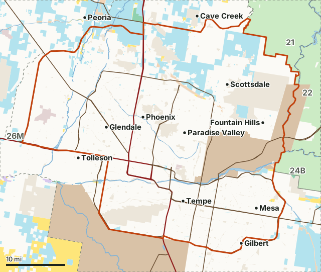
National forestBLMState trust landAZGFD landBureau of ReclamationMilitary (closed or by permit)Tribal land (tribal permit)City, county and otherUnit 25MNeighboring unitsLake or riverHighway
| AZGFD region | Region 6 (Mesa) |
|---|---|
| Size | 1,285 square miles (822,125 acres) |
| Public land open to hunting | 8.4% (69,136 acres) |
| Towns in and near it | Phoenix, Scottsdale, Mesa, Carefree, Chandler and Tolleson |
| Highways | AZ 101, US 60, AZ 202 and I-17 |
How much public land is in Unit 25M?
8.4% of Unit 25M is public land open to hunting: 69,136 of 822,125 acres. The largest share is state trust land, 63,760 acres or 7.8% of the unit.
| Manager | Acres | Share of Unit 25M |
|---|---|---|
| City, county and other | 89,523 | 10.9% |
| Tribal land (tribal permit) | 64,845 | 7.9% |
| State trust land | 63,760 | 7.8% |
| Military (closed or by permit) | 3,446 | 0.4% |
| Bureau of Reclamation | 3,041 | 0.4% |
| BLM | 2,277 | 0.3% |
| National forest | 49 | under 0.1% |
| AZGFD land | 9 | under 0.1% |
Measured by FilledTag inside AZGFD's unit boundary from USGS PAD-US 4.1 (fee managers). Public land open to hunting here means national forest, BLM, state trust land, AZGFD land, national wildlife refuges, national recreation areas and Bureau of Reclamation land. Tribal land, military land and national parks are counted on their own rows and left out of that figure. Arizona State Land Department rules let a licensed hunter on state trust land while hunting; other uses need its recreation permit.
What can you hunt in Unit 25M in 2026?
AZGFD's 2026 booklets list no draw hunt that includes Unit 25M.
Over-the-counter archery deer, 2024: AZGFD estimates 235 archers hunted Unit 25M for 1,677 days and took 22 deer (mule deer bucks 22, whitetail bucks 0) (AZGFD 2024 Over-the-Counter Archery Deer Harvest Summary).
What did AZGFD's 2025 surveys count in Unit 25M?
Mule deer: 133 classified in 37 groups, 16 bucks and 30 young per 100 does.
Source: AZGFD 2025 Mule Deer Survey Summary.
How do you get to Unit 25M?
Highways through the unit: AZ 101 (about 65 miles inside it), US 60 (about 58 miles inside it), AZ 202 (about 56 miles inside it), I-17 (about 31 miles inside it) and AZ 87 (about 26 miles inside it). Towns and places inside: Phoenix, Scottsdale, Mesa, Gilbert, Glendale and Tempe. Nearby towns: Carefree (on the line), Chandler (on the line), Tolleson (on the line) and Cave Creek (2 miles).
Which units border Unit 25M?
Unit 25M touches 4 other units. Their size, public land and the number of 2026 draw hunts that include each:
| Unit | Square miles | Public land | Elk hunts | Deer hunts | Pronghorn hunts |
|---|---|---|---|---|---|
| Unit 21 | 1,052 | 97.1% | 4 | 5 | 2 |
| Unit 22 | 1,574 | 95.5% | 13 | 6 | |
| Unit 24B | 779 | 94.3% | 5 | ||
| Unit 26M | 2,103 | 17.7% |
Questions hunters ask
How much public land is in Arizona Unit 25M?
8.4% of Unit 25M is public land open to hunting, 69,136 of its 822,125 acres; the largest share is state trust land at 63,760 acres. 64,845 acres are tribal land, which needs the tribe's own permit. 3,446 acres are military land.
What can you hunt in Unit 25M in 2026?
AZGFD's 2026 draw lists no hunt that includes Unit 25M. Over-the-counter seasons are set statewide in AZGFD's regulations.
What is the closest town to Unit 25M?
Phoenix, Scottsdale and Mesa are inside the unit. Just outside: Carefree (on the line), Chandler (on the line) and Tolleson (on the line).
Which AZGFD region is Unit 25M in?
Region 6, run from the Mesa office. It borders Unit 21, Unit 22, Unit 24B and Unit 26M.
Get Arizona updates from FilledTag
Join the Arizona list and FilledTag will email you when it adds more for Arizona hunters.
The free FilledTag app for iPhone has a map that works in every state, Arizona included.
Where these numbers come from
- Hunts and permits: AZGFD's 2026 Pronghorn and Elk booklet and 2026-27 regulations.
- Harvest: AZGFD harvest summaries (AZGFD harvest reporting).
- Public land: USGS PAD-US 4.1 (fee managers). Unit boundary: AZGFD game management unit boundaries.
- Highways and towns: U.S. Census Bureau TIGER/Line 2024 primary and secondary roads; U.S. Census Bureau 2024 Gazetteer, places.
FilledTag is not part of the Arizona Game and Fish Department. Numbers are copied from AZGFD's published reports or measured from AZGFD and USGS maps; nothing here is estimated by FilledTag. AZGFD's regulations are the final word on every rule.