Robbins Butte Wildlife Area: hunting rules and access
Robbins Butte Wildlife Area is 5,677 acres, measured from AZGFD's boundary, in game management units 39, 26M and 41, Maricopa County, AZGFD Region 6. AZGFD's rule for hunting here: "Open to all hunting in season as permitted under R12-4-304 and R12-4-318."
Data updated October 2026. Rules: AZGFD's wildlife area layer, rules dated 2014. Boundary: AZGFD. Hunts: AZGFD's 2026 booklets.
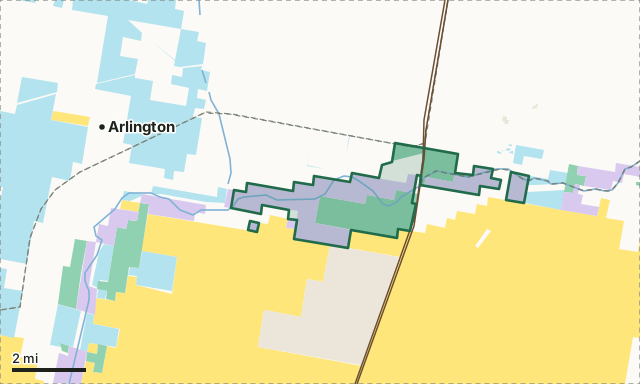
BLMState trust landAZGFD landNational wildlife refugeCity, county and otherRobbins Butte Wildlife AreaUnit lineLake or riverHighway
| Size | 5,677 acres (measured from AZGFD's boundary) |
|---|---|
| Units | Unit 39, Unit 26M, Unit 41 |
| AZGFD region | Region 6, Mesa |
| County | Maricopa |
| Hunting | Open to all hunting in season as permitted under R12-4-304 and R12-4-318. |
| Camping | No overnight public camping. |
| Firearms | Posted portions around Department housing closed to discharge of all firearms. |
| Nearest towns | Arlington (4 mi), Buckeye (6 mi) and Wintersburg (11 mi) |
What are the rules on Robbins Butte Wildlife Area?
AZGFD lists 9 rules for the area:
- No open fires.
- No firewood cutting or gathering.
- No overnight public camping.
- Motorized vehicle travel permitted on designated roads, trails, or areas only from one hour before sunrise to one hour after sunset daily.
- Parking in designated areas only.
- If conducted during an event approved under R12-4-804, target or clay bird shooting permitted in designated areas only.
- Posted portions around Department housing closed to discharge of all firearms.
- Closed to discharge of centerfire rifled firearms.
- Open to all hunting in season as permitted under R12-4-304 and R12-4-318.
From AZGFD's wildlife area layer. R12-4-304 and R12-4-318, named in the rules, are the Commission's rules on lawful methods and seasons. Posted signs on the ground and AZGFD's current regulations come first.
What is Robbins Butte Wildlife Area?
The Robbins Butte Wildlife Area (RBWA) is located approximately seven miles southwest of Buckeye, Arizona, comprising approximately 1681 acres.
AZGFD's description of the area, from its wildlife area detail layer (2016). Acres quoted in AZGFD's text can differ from the measured size above.
Which hunts include Robbins Butte Wildlife Area's units?
Unit 39, Unit 26M and Unit 41: AZGFD's 2026 lists have 0 elk hunts, 3 deer hunts and 0 pronghorn hunts that include them, each for the whole hunt area, not the wildlife area alone.
| Unit | Area acres in the unit | Elk hunts | Deer hunts | Pronghorn hunts | Public land in the unit |
|---|---|---|---|---|---|
| Unit 39 | 5,234 | 0 | 2 | 0 | 72.6% |
| Unit 26M | 437 | 0 | 0 | 0 | 17.7% |
| Unit 41 | 6 | 0 | 2 | 0 | 56% |
How do you get to Robbins Butte Wildlife Area?
Highways within 8 miles: AZ 85 and I-10. Nearest towns: Arlington (4 miles), Buckeye (6 miles), Wintersburg (11 miles) and Goodyear (13 miles). AZGFD names Buckeye as the nearby city. Vehicles: Motorized vehicle travel permitted on designated roads, trails, or areas only from one hour before sunrise to one hour after sunset daily.
Questions hunters ask
Can you hunt on Robbins Butte Wildlife Area?
Open to all hunting in season as permitted under R12-4-304 and R12-4-318. That is AZGFD's rule for the area; seasons and permits follow the regulations for Units 39, 26M and 41.
Can you camp on Robbins Butte Wildlife Area?
AZGFD's rule: "No overnight public camping."
Which unit is Robbins Butte Wildlife Area in?
Unit 39 (5,234 acres), Unit 26M (437 acres) and Unit 41 (6 acres), by AZGFD's boundaries.
What town is near Robbins Butte Wildlife Area?
Arlington (4 miles), Buckeye (6 miles) and Wintersburg (11 miles), by straight-line distance from the area's boundary.
Get Arizona updates from FilledTag
Join the Arizona list and FilledTag will email you when it adds more for Arizona hunters.
The free FilledTag app for iPhone has a map that works in every state, Arizona included.
Where these facts come from
- Rules and boundary: AZGFD wildlife areas; description and nearby city: AZGFD wildlife area details (2016).
- Hunts: AZGFD's 2026 booklets. Surrounding public land: USGS PAD-US 4.1 (fee managers).
- Highways and towns: U.S. Census Bureau TIGER/Line 2024 primary and secondary roads; U.S. Census Bureau 2024 Gazetteer, places.
FilledTag is not part of the Arizona Game and Fish Department. Numbers are copied from AZGFD's published reports or measured from AZGFD and USGS maps; nothing here is estimated by FilledTag. AZGFD's regulations are the final word on every rule.