Daugherty Hill Wildlife Area: hunting rules and map
Daugherty Hill Wildlife Area is 8,763 acres of CDFW land in Yuba County, in CDFW's North Central Region. Title 14, Section 551 lists it as Type C: open daily for hunting all legal species without a hunting pass, except where CDFW's area rules say otherwise. It lies in deer Zone D3, where CDFW estimates 2,509 deer were taken in 2025.
Data updated October 2026. Rules: CDFW's 2026-2027 land use regulations (updated July 1, 2026). Boundary and acres: CDFW. Zones: CDFW. Land around it: CPAD 2026a.
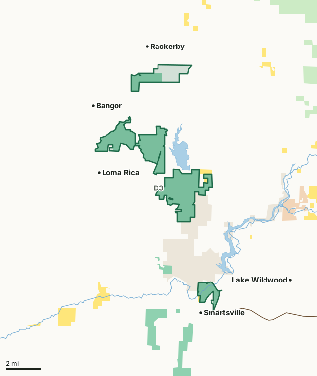
BLMCDFW landOther state or federal landDaugherty Hill WADeer zone lineLake or riverHighway
| Size | 8,763 acres (CDFW boundary) |
|---|---|
| CDFW region | Region 2, North Central Region |
| County | Yuba |
| Wildlife area type | Type C |
| Closures | Closed to hunting February 1 through June 30 except for the spring turkey season when only turkeys may be hunted. |
| Camping | No tent camping. |
| Deer zone | Zone D3 |
| Nearest towns | Smartsville (next to it), Rackerby (next to it) and Loma Rica (next to it) |
What are CDFW's rules for Daugherty Hill Wildlife Area?
As a Type C area, Daugherty Hill WA needs no hunting pass; the rows below are CDFW's own limits for it.
| Rule | Unit | CDFW's words |
|---|---|---|
| Camping | Whole area | No tent camping. Overnight parking with camp trailers allowed only in designated parking lots. |
| Closures and restrictions | Whole area | Closed to hunting February 1 through June 30 except for the spring turkey season when only turkeys may be hunted. Closed to all visitor entry during the first nine days of the spring turkey season except for special turkey permit holders. The Black Swan area of the Yuba Narrows Unit is closed to hunting. |
| Shoot days and special drawings | Whole area | Special draw entry permits are required for the first nine days of the spring turkey season. |
| Firearms | Whole area | During spring turkey season, only shotguns, archery equipment, and air rifles firing pellets of a minimum 0.177 caliber and powered by compressed air or gas may be used. |
Source: CDFW 2026-2027 Waterfowl, Upland Game, and Public Use of Department Lands Regulations, Title 14, Section 551. CDFW's page for Daugherty Hill Wildlife Area has maps and contacts. Deer, elk and pronghorn hunting also follow the zone's own season and tag.
What does CDFW say about Daugherty Hill Wildlife Area?
The Daugherty Hill Wildlife Area is approximately 7,000 acres of rolling hills covered with blue and live oak, gray pine, thick brush, and poison oak. There are five units and the approximate acreages are: Daugherty Hill (3,200 acres), Donovan Hill (1,800 acres), Quail Valley (1,300 acres), Darby Road (1,600 acres) and Yuba Narrows (710 acres). Hunting is not allowed on the Black Swan area of the Yuba Narrows Unit but fishing and bird watching opportunities are abundant in the Black Swan area.
Popular game species on these areas include dove, quail, turkeys, deer, and some jump shooting opportunities for waterfowl.
On hunting, CDFW's page says: Deer: Zone D-3. Small resident population; Columbian black-tailed deer migrate down from higher elevations in Plumas and Sierra counties in late October.
CDFW lists big game, small game and upland game birds hunting for the area, and also wildlife viewing and hiking trails.
From CDFW's page for Daugherty Hill Wildlife Area, read October 2026.
Which hunt zones is Daugherty Hill Wildlife Area in?
CDFW's numbers for each zone are for the whole zone, not the wildlife area alone.
| Zone | Acres of Daugherty Hill WA in it | CDFW's latest numbers for the zone |
|---|---|---|
| Deer Zone D3 | 8,763 | 2,509 deer taken in 2025, 19% hunter success; 2026 general season September 26 to November 1 |
CDFW deer hunts whose ground includes part of Daugherty Hill WA: hunt J-16 (Bucks Mountain-Nevada City Apprentice Either-Sex Deer Hunt) and hunt J-8 (Daugherty Hill Wildlife Area Apprentice Either-Sex Deer Hunt).
Harvest: CDFW California Deer Harvest Statistics (2020 to 2025). Acres measured by FilledTag from CDFW's boundaries.
What public land is around Daugherty Hill Wildlife Area?
Within 4 miles of its boundary, CPAD 2026a maps 9,923 acres of CDFW land, 6,795 acres of other state or federal land and 561 acres of BLM land.
How do you get to Daugherty Hill Wildlife Area?
CDFW's directions: Daugherty Hill Unit:The parking lot for the Daugherty Hill unit is located one mile east of Marysville Road on Dolan Harding Road. Fee access to the Daugherty Hill Unit is also available through the Collins Lake Recreation Area. Donovan Hill Unit: Take Highway 20 to Marysville Road; proceed north (left) on Marysville Road about 8.3 miles to the second Dolan Harding Road intersection.
CDFW's location note: North of Highway 20 approximately 17 miles east of Marysville. Highways within 8 miles: CA 20. Nearest towns: Smartsville (next to it), Rackerby (next to it), Loma Rica (next to it) and Bangor (2 miles).
Questions hunters ask
Can you hunt on Daugherty Hill Wildlife Area?
Yes. Section 551 lists it as Type C. Type C areas are open daily for all legal species, unless CDFW's area rules say otherwise. CDFW's closure: Closed to hunting February 1 through June 30 except for the spring turkey season when only turkeys may be hunted. Closed to all visitor entry during the first nine days of the spring turkey season except for special turkey permit holders. The Black Swan area of the Yuba Narrows Unit is closed to hunting.
Can you camp on Daugherty Hill Wildlife Area?
CDFW's rule: No tent camping. Overnight parking with camp trailers allowed only in designated parking lots. Where camping is allowed, a visitor may stay up to seven nights in a row and fourteen nights a year (Section 550(p)).
Which deer zone is Daugherty Hill Wildlife Area in?
All of it is in deer Zone D3, by CDFW's boundaries. CDFW estimates 2,509 deer were taken in Zone D3 in 2025, across the whole zone.
What is the closest town to Daugherty Hill Wildlife Area?
Smartsville (next to it), Rackerby (next to it) and Loma Rica (next to it), by the Census Bureau's places.
Get a California hunt plan when they open
Hunt plans for California are coming. Join the list and you'll hear first. The first 50 hunters in each new state get their plan free.
Until then, the free FilledTag app for iPhone has a map that works in every state, California included.
Where these facts come from
- Rules: CDFW 2026-2027 Waterfowl, Upland Game, and Public Use of Department Lands Regulations.
- Boundary and acres: CDFW public access lands (BIOS ds3077); CDFW, Daugherty Hill Wildlife Area.
- Zones: CDFW BIOS zone layers. Surrounding public land: California Protected Areas Database (CPAD) 2026a.
- Deer harvest: CDFW California Deer Harvest Statistics (2020 to 2025).
FilledTag is not part of the California Department of Fish and Wildlife.