Oroville Wildlife Area: hunting rules and map
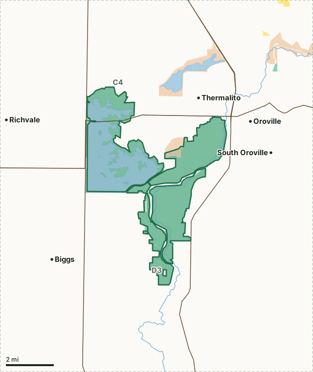
Oroville Wildlife Area is 11,598 acres of CDFW land in Butte County, in CDFW's North Central Region. Title 14, Section 551 lists it as Type C: open daily for hunting all legal species without a hunting pass, except where CDFW's area rules say otherwise. It lies in deer Zone D3, where CDFW estimates 2,509 deer were taken in 2025.
Data updated October 2026. Rules: CDFW's 2026-2027 land use regulations (updated July 1, 2026). Boundary and acres: CDFW. Zones: CDFW. Land around it: CPAD 2026a.
BLMCDFW landState parkOroville WADeer zone lineLake or riverHighway
| Size | 11,598 acres (CDFW boundary) |
|---|---|
| CDFW region | Region 2, North Central Region |
| County | Butte |
| Wildlife area type | Type C |
| Closures | Closed to hunting February 1 through August 31 except during the spring turkey season when only turkeys may be hunted through a special drawing. |
| Camping | Allowed only in designated camping sites by permit issued from the Oroville CHP office at (530) 538-2700. |
| Deer zone | Zone D3, Zone C4 |
| Nearest towns | Thermalito (next to it), Oroville (next to it) and South Oroville (2 mi) |
What are CDFW's rules for Oroville Wildlife Area?
As a Type C area, Oroville WA needs no hunting pass; the rows below are CDFW's own limits for it.
| Rule | Unit | CDFW's words |
|---|---|---|
| Camping | Whole area | Allowed only in designated camping sites by permit issued from the Oroville CHP office at (530) 538-2700. |
| Fire | Whole area | Fires are prohibited except for the use of portable gas stoves within designated campsites. |
| Closures and restrictions | Whole area | Closed to hunting February 1 through August 31 except during the spring turkey season when only turkeys may be hunted through a special drawing. Dogs are prohibited from March 2 through June 30. |
| Shoot days and special drawings | Whole area | Special draw entry permits are required for the spring turkey season. |
| Firearms | Whole area | Rifles and pistols are prohibited except at the portion of the area designated as a shooting range. |
Source: CDFW 2026-2027 Waterfowl, Upland Game, and Public Use of Department Lands Regulations, Title 14, Section 551. CDFW's page for Oroville Wildlife Area has maps and contacts. Deer, elk and pronghorn hunting also follow the zone's own season and tag.
What does CDFW say about Oroville Wildlife Area?
The approximately 11,800-acre Oroville Wildlife Area is primarily riparian woodland habitat along the Feather River and grasslands around the Thermalito Afterbay. Warm water fish species (largemouth bass, bluegill, green sunfish, channel catfish, and black crappie) can be found in the numerous dredger ponds and the Thermalito Afterbay. Salmon, steelhead, shad, and striped bass can be found in the Feather River.
Wildlife species seen in the area include coyote, badger, fox, bobcat, porcupine, osprey, white-tailed kite, egrets, woodpeckers, and warblers. There are good populations of coyotes, deer, dove, quail, and waterfowl, and fair populations of squirrel and rabbit.
CDFW lists big game, small game and upland game birds hunting for the area, and also wildlife viewing, fishing and camping.
Facilities, in CDFW's words: camping, restrooms, and launch access
From CDFW's page for Oroville Wildlife Area, read October 2026.
Which hunt zones is Oroville Wildlife Area in?
CDFW's numbers for each zone are for the whole zone, not the wildlife area alone.
| Zone | Acres of Oroville WA in it | CDFW's latest numbers for the zone |
|---|---|---|
| Deer Zone D3 | 10,192 | 2,509 deer taken in 2025, 19% hunter success; 2026 general season September 26 to November 1 |
| Deer Zone C4 | 1,406 | 1,129 deer taken in 2025, 30.1% hunter success; 2026 general season September 19 to October 4 |
CDFW deer hunts whose ground includes part of Oroville WA: hunt G-1 (Late Season Buck Hunt for Zone C-4) and hunt A-1 (C Zones Archery Only Hunt).
Harvest: CDFW California Deer Harvest Statistics (2020 to 2025). Acres measured by FilledTag from CDFW's boundaries.
What public land is around Oroville Wildlife Area?
Within 4 miles of its boundary, CPAD 2026a maps 11,685 acres of CDFW land and 1,777 acres of state park land.
How do you get to Oroville Wildlife Area?
CDFW's directions: Access is via Highway 162 to the headquarters entrance, about 1/2 mile west of Highway 70, or at Larkin Road. Access for Thermalito Afterbay Unit is Wilbur Road at Hwy 162. The Thermalito Unit is five miles west of Oroville, east of Highway 99. Shooting range access is via Rabe Road.
CDFW's location note: 945 Oro Dam Blvd, West Oroville, CA 95965(adjacent to the Feather River, west of Hwy 70 and south of Highway 162). Highways within 8 miles: CA 70, CA 99, CA 162, CA 149 and CA 191. Nearest towns: Thermalito (next to it), Oroville (next to it), South Oroville (2 miles) and Biggs (3 miles).
Questions hunters ask
Can you hunt on Oroville Wildlife Area?
Yes. Section 551 lists it as Type C. Type C areas are open daily for all legal species, unless CDFW's area rules say otherwise. CDFW's closure: Closed to hunting February 1 through August 31 except during the spring turkey season when only turkeys may be hunted through a special drawing. Dogs are prohibited from March 2 through June 30.
Can you camp on Oroville Wildlife Area?
CDFW's rule: Allowed only in designated camping sites by permit issued from the Oroville CHP office at (530) 538-2700. Where camping is allowed, a visitor may stay up to seven nights in a row and fourteen nights a year (Section 550(p)).
Which deer zone is Oroville Wildlife Area in?
Zone D3 (10,192 acres) and Zone C4 (1,406 acres), by CDFW's boundaries. CDFW estimates 2,509 deer were taken in Zone D3 in 2025, across the whole zone.
What is the closest town to Oroville Wildlife Area?
Thermalito (next to it), Oroville (next to it) and South Oroville (2 miles), by the Census Bureau's places.
Get a California hunt plan when they open
Hunt plans for California are coming. Join the list and you'll hear first. The first 50 hunters in each new state get their plan free.
Until then, the free FilledTag app for iPhone has a map that works in every state, California included.
Where these facts come from
- Rules: CDFW 2026-2027 Waterfowl, Upland Game, and Public Use of Department Lands Regulations.
- Boundary and acres: CDFW public access lands (BIOS ds3077); CDFW, Oroville Wildlife Area.
- Zones: CDFW BIOS zone layers. Surrounding public land: California Protected Areas Database (CPAD) 2026a.
- Deer harvest: CDFW California Deer Harvest Statistics (2020 to 2025).
FilledTag is not part of the California Department of Fish and Wildlife.