Connecticut Deer Management Zone 8: deer harvest, towns and public land
Hunters took 341 deer on private land in Connecticut's Deer Management Zone 8 in 2025, not counting landowner tags, against 273 in 2024 and a five-year average of 301. In the private land shotgun/rifle season DEEP puts the 2025 harvest at 1 deer per square mile, with 24% of hunters successful. The zone covers 204 square miles, 13.9% of it public land.
Data updated October 2026. Harvest: CT DEEP 2025 Connecticut Deer Program Summary. Seasons: CT DEEP 2026 Connecticut Hunting and Trapping Guide. Land: DEEP and PAD-US.
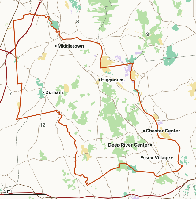
Wildlife management areaState forestState parkOther DEEP landNational wildlife refugeZone 8Neighboring zonesHighway
| Size | 204 square miles |
|---|---|
| Private land deer, 2025 | 341 (all seasons but landowner) |
| Private land shotgun/rifle, 2025 | 163 deer by about 689 hunters (24% success) |
| Shotgun/rifle harvest per square mile | 1 in 2025, 0.5 in 2024 |
| Deer reported in its towns, 2025 | 516 by hunters in 8 towns |
| Public land | 13.9% (18,179 acres) |
| State hunting areas with a page | Cockaponset SF, Wopowog WMA, Black Pond WMA, Cromwell Meadows WMA |
| Private land firearms bag, 2026 | 1 either-sex and 1 antlerless |
| January archery | No (Zones 11 and 12 only) |
How many deer are taken in Zone 8 each year?
Private land deer in every season but the landowner season, 2015 to 2025:
| Year | Private land deer |
|---|---|
| 2025 | 341 |
| 2024 | 273 |
| 2023 | 271 |
| 2022 | 323 |
| 2021 | 295 |
| 2020 | 358 |
| 2019 | 418 |
| 2018 | 408 |
| 2017 | 423 |
| 2016 | 368 |
| 2015 | 342 |
Source: CT DEEP 2025 Connecticut Deer Program Summary, Table 11. The zone rows add up to the table's statewide total in every year.
How crowded and how successful is the shotgun/rifle season in Zone 8?
| Year | Deer per square mile | Hunters per square mile | Hunter success |
|---|---|---|---|
| 2025 | 1 | 4.1 | 24% |
| 2024 | 0.5 | 4.6 | 11% |
| 2023 | 0.7 | 4.6 | 15% |
Source: CT DEEP 2025 Connecticut Deer Program Summary, Table 6, from DEEP's hunter survey of private land shotgun/rifle hunters. Square miles here are DEEP's huntable area for the zone, 169.1.
Which towns in Zone 8 have the most deer reported?
| Town | Archery | Shotgun/rifle | Landowner | Muzzleloader | Hunters' deer |
|---|---|---|---|---|---|
| Middletown | 54 | 58 | 0 | 4 | 116 |
| Haddam | 33 | 51 | 8 | 5 | 97 |
| Killingworth | 36 | 38 | 3 | 5 | 82 |
| Durham | 28 | 29 | 10 | 8 | 75 |
| Deep River | 10 | 11 | 13 | 3 | 37 |
| Middlefield | 22 | 13 | 0 | 2 | 37 |
| Chester | 12 | 16 | 5 | 3 | 36 |
| Essex | 5 | 2 | 28 | 1 | 36 |
Source: CT DEEP 2025 Connecticut Deer Program Summary, Appendix 1. Each town is listed under the zone that holds its centre, so a town on a zone line counts wholly on one side.
Which state hunting areas in Zone 8 give up the most deer?
| State hunting area | Deer, 2025 | Deer, 2024 | DEEP's huntable square miles |
|---|---|---|---|
| Cockaponset SF | 94 | 100 | 26.85 |
| Wopowog WMA | 8 | 3 | 0.73 |
| Black Pond WMA | 1 | 0 | 0.11 |
| Cromwell Meadows WMA | 1 | 3 | 0.79 |
| Durham Meadows WMA | 1 | 1 | 0.8 |
| Messerschmidt Pond WMA | 1 | 1 | 0.72 |
| Higganum Meadows WMA (off Clarkhurst Road) | 0 | 3 | 0.4 |
Source: CT DEEP 2025 Connecticut Deer Program Summary, Appendix 2; CT DEEP 2024 Connecticut Deer Program Summary.
When are the 2026 deer seasons in Zone 8?
| Season | Dates, 2026 | Bag |
|---|---|---|
| Archery, private land | September 15 to December 31 | 2 either-sex and 2 antlerless |
| Archery, state land | September 15 to November 17 and December 23 to 31 (bowhunting-only areas September 15 to December 31) | Same archery tags |
| Junior deer hunter training days | November 7 to 14 | Junior hunters with firearms deer permits |
| Shotgun/rifle, private land | November 18 to December 8 | 1 either-sex and 1 antlerless |
| Shotgun, state land (lottery and no-lottery) | November 18 to December 8 (lottery A season November 18 to 27) | By permit |
| Muzzleloader, private land | December 9 to 31 | 1 either-sex and 1 antlerless |
| Muzzleloader, state land | December 9 to 22 | By permit |
| Landowner | November 1 to December 31 | Owners of 10 or more acres and family |
Sunday deer hunting is allowed on private land only, not within 40 yards of blazed public trails. Bowhunters wear 400 square inches of fluorescent orange from November 18 to December 31.
Source: CT DEEP 2026 Connecticut Hunting and Trapping Guide.
How much public land is in Zone 8?
13.9% of Zone 8 is public land: 18,179 of its 130,754 acres. The largest share is state forest, 14,466 acres.
| Manager | Acres | Share of Zone 8 |
|---|---|---|
| State forest | 14,466 | 11.1% |
| State park | 2,037 | 1.6% |
| Wildlife management area | 1,054 | 0.8% |
| National wildlife refuge | 535 | 0.4% |
| Other DEEP land | 87 | 0.1% |
Measured by FilledTag inside DEEP's zone line from Connecticut DEEP Property for state land; USGS Protected Areas Database of the United States (PAD-US 4.1) for federal land. Not every acre of DEEP land is open to deer hunting; DEEP's guide lists the state lands open to each season.
Which zones border Zone 8?
| Zone | Private land deer, 2025 | Shotgun/rifle deer per square mile | Hunter success | Public land |
|---|---|---|---|---|
| Zone 3 | 536 | 0.8 | 35% | 4.4% |
| Zone 7 | 710 | 0.6 | 31% | 3.9% |
| Zone 9 | 585 | 1 | 34% | 9.4% |
| Zone 12 | 734 | 0.7 | 33% | 5.7% |
Highways crossing Zone 8: CT 9 (44 miles), CT 154 (19 miles), CT 148 (15 miles), CT 17 (14 miles), CT 81 (12 miles) and CT 80 (11 miles). Towns inside: Middletown.
Questions hunters ask
How many deer are taken in Connecticut Zone 8?
341 on private land in 2025, counting archery, shotgun/rifle and muzzleloader but not landowner tags (CT DEEP 2025 Connecticut Deer Program Summary, Table 11). The five years to 2025 averaged 301; the most since 2015 was 423 in 2017.
What share of hunters get a deer in Zone 8?
DEEP's hunter survey puts private land shotgun/rifle success in Zone 8 at 24% in 2025, 11% in 2024 and 15% in 2023, with 4.1 hunters per square mile in 2025 (CT DEEP 2025 Connecticut Deer Program Summary, Table 6).
How many deer can you take in Zone 8 in 2026?
On private land in the shotgun/rifle and muzzleloader seasons: 1 either-sex and 1 antlerless (CT DEEP 2026 Connecticut Hunting and Trapping Guide). Archery tags allow 2 either-sex and 2 antlerless deer.
Which towns in Zone 8 have the most deer taken?
Middletown (116), Haddam (97) and Killingworth (82) in 2025, counting archery, shotgun/rifle, landowner and muzzleloader deer reported in each town (CT DEEP 2025 Connecticut Deer Program Summary, Appendix 1).
Get a Connecticut hunt plan when they open
Hunt plans for Connecticut are coming. Join the list and you'll hear first. The first 50 hunters in each new state get their plan free.
Until then, the free FilledTag app for iPhone has a map that works in every state, Connecticut included.
Where these numbers come from
- Harvest: CT DEEP 2025 Connecticut Deer Program Summary; DEEP 2024 deer summary; DEEP 2023 deer summary; DEEP 2022 deer summary.
- Seasons and bag limits: CT DEEP 2026 Connecticut Hunting and Trapping Guide.
- Zone boundary: Connecticut DEEP Deer and Turkey Management Zones. Public land: Connecticut DEEP Property for state land; USGS Protected Areas Database of the United States (PAD-US 4.1) for federal land.
- Highways and towns: U.S. Census Bureau TIGER/Line 2024 primary and secondary roads; U.S. Census Bureau 2024 Gazetteer, places.
FilledTag is not part of the Connecticut Department of Energy and Environmental Protection. Numbers are copied from DEEP and federal sources or measured from their maps; nothing on this page is estimated by FilledTag.