Old Furnace Wildlife Area: hunting, deer stands, parking and map
Old Furnace Wildlife Area is 2,149 acres of Delaware Division of Fish and Wildlife land in Sussex County, inside Wildlife Management Zone 11. DNREC's maps show 2 deer stands (2 for hunters with disabilities) and 7 parking lots with 22 spaces. Hunters took 62 deer on state wildlife areas in Zone 11 in 2025-26, of 1,381 in the zone.
Data updated October 2026. Area, stands and parking: DNREC's FirstMap layers. Zone harvest: DNREC deer harvest by zone (Delaware Deer Harvest Information Dashboard data). Seasons: 2026/27 Delaware Hunting and Trapping Guide, deer seasons (DNREC).
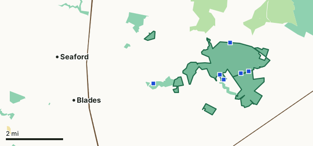
State wildlife areaState forestState parkOld Furnace Wildlife AreaDNREC parkingZone lineHighway
| Size | 2,149 acres (DNREC) |
|---|---|
| Wildlife Management Zone | Zone 11 |
| County | Sussex |
| Deer stands (DNREC) | 2, 2 of them for hunters with disabilities |
| Parking | 7 lots, 22 spaces; 6 need a Conservation Access Pass |
| Tracts named on DNREC's maps | Main Tract and Lang Tract |
| Chronic wasting disease | Inside DNREC's CWD Management Zone: no baiting, November firearm check-in |
| Nearest towns | Seaford (3 mi), Blades (3 mi) and Bridgeville (5 mi) |
Where do you park at Old Furnace Wildlife Area?
DNREC maps 7 parking lots on Old Furnace Wildlife Area:
| Lot | Tract | Surface | Spaces | Conservation Access Pass | Latitude, longitude |
|---|---|---|---|---|---|
| 1 | Main Tract | Paved | 10 | No | 38.64376, -75.55139 |
| 2 | Main Tract | Turf | 4 | Yes | 38.64993, -75.49007 |
| 3 | Main Tract | Stone | 2 | Yes | 38.66449, -75.50200 |
| 4 | Main Tract | Turf | 2 | Yes | 38.64891, -75.49500 |
| 5 | Main Tract | Turf | 2 | Yes | 38.64587, -75.50610 |
| 6 | Lang Tract | Turf | 1 | Yes | 38.72320, -75.38705 |
| 7 | Main Tract | Turf | 1 | Yes | 38.64833, -75.50850 |
Source: DNREC wildlife area parking (FirstMap).
What stands, blinds and fields does DNREC mark on Old Furnace Wildlife Area?
2 deer stands (2 for hunters with disabilities). They are spread over 2 tracts: Main Tract and Lang Tract.
Source: DNREC wildlife area stands, blinds and fields (FirstMap). DNREC Wildlife Area Maps and Regulations has how stands are assigned and used.
How many deer are taken around Old Furnace Wildlife Area?
| Zone | Deer, 2025-26 | On state wildlife areas, 2025-26 | Deer, 2024-25 | On state wildlife areas, 2024-25 |
|---|---|---|---|---|
| Zone 11 | 1,381 | 62 | 1,567 | 75 |
Source: DNREC deer harvest by zone (Delaware Deer Harvest Information Dashboard data). DNREC reports wildlife area deer by zone, not by area.
When can you hunt Old Furnace Wildlife Area in 2026-27?
Archery and crossbow September 1 to January 31; muzzleloader October 9 to 18 and January 25 to 31; general firearm November 13 to 22 and January 16 to 24; special antlerless days October 2 to 4, 23 to 25 and 30 to 31 and December 12 to 20; handgun January 2 to 10. Wildlife areas may set their own days and rules; DNREC Wildlife Area Maps and Regulations has them.
Source: 2026/27 Delaware Hunting and Trapping Guide, deer seasons (DNREC).
How do you get to Old Furnace Wildlife Area?
Highways within five miles: US 13, US 9 and US 113. Nearest towns: Seaford (3 miles), Blades (3 miles), Bridgeville (5 miles) and Laurel (5 miles).
Questions hunters ask
Are there deer stands on Old Furnace Wildlife Area?
Yes. DNREC's wildlife area layer shows 2 deer stands on Old Furnace Wildlife Area, 2 of them set aside for hunters with disabilities (DNREC wildlife area stands, blinds and fields (FirstMap)). DNREC Wildlife Area Maps and Regulations has the rules for using them.
Where do you park at Old Furnace Wildlife Area?
DNREC maps 7 parking lots with 22 spaces in all; 6 of them need a Conservation Access Pass on the vehicle. The largest is at 38.64376, -75.55139 (10 spaces) (DNREC wildlife area parking (FirstMap)).
What zone is Old Furnace Wildlife Area in?
Zone 11. Hunters took 1,381 deer in Zone 11 in 2025-26, 294 of them on public land (DNREC deer harvest by zone (Delaware Deer Harvest Information Dashboard data)).
Get a Delaware hunt plan when they open
Hunt plans for Delaware are coming. Join the list and you'll hear first. The first 50 hunters in each new state get their plan free.
Until then, the free FilledTag app for iPhone has a map that works in every state, Delaware included.
Where these facts come from
- Area and acres: DNREC managed lands (FirstMap). Stands, blinds and fields: DNREC wildlife area stands, blinds and fields (FirstMap). Parking: DNREC wildlife area parking (FirstMap).
- Zone harvest: DNREC deer harvest by zone (Delaware Deer Harvest Information Dashboard data). Seasons: 2026/27 Delaware Hunting and Trapping Guide, deer seasons (DNREC). Rules: DNREC Wildlife Area Maps and Regulations.
- Public land around it: DNREC managed lands (FirstMap) for state land; USGS Protected Areas Database of the United States (PAD-US 4.1) for federal land. Highways and towns: U.S. Census Bureau TIGER/Line 2024 primary and secondary roads; U.S. Census Bureau 2024 Gazetteer, places.
FilledTag is not part of the Delaware Department of Natural Resources and Environmental Control.