Delaware Wildlife Management Zone 14: deer harvest, public land and seasons
Hunters took 875 deer in Delaware's Wildlife Management Zone 14 in the 2025-26 season, 237 antlered and 638 antlerless, against 843 the season before. 190 came off public land and 685 off private land. The zone is in Sussex County and inside DNREC's CWD Management Zone; 12.3% of it is public land.
Data updated October 2026. Harvest: DNREC Delaware Deer Harvest Information Dashboard. Seasons: 2026/27 Delaware Hunting and Trapping Guide, deer seasons (DNREC). Land: DNREC and PAD-US.
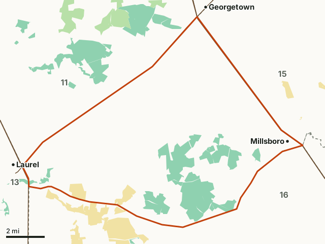
State wildlife areaState forestState parkZone 14Neighboring zonesHighway
| Boundary (DNREC) | Land bordered north by Route 9, south by Route 24, east by Route 113, and south by Route 24. |
|---|---|
| County | Sussex County |
| Deer taken, 2025-26 | 875 (237 antlered, 638 antlerless) |
| On public land, 2025-26 | 190 (21.7%) |
| Spring turkeys, 2026 | 35 |
| Public land | 12.3% (6,288 acres) |
| Wildlife areas | Midlands Wildlife Area |
| Chronic wasting disease | Inside the CWD Management Zone (Zones 11, 14 and 16): no baiting, November firearm check-in |
| Handgun season, 2027 | January 2 to 10 |
How many deer are taken in Zone 14 each season?
| Season | Antlered | Antlerless | All deer | Public land | Private land |
|---|---|---|---|---|---|
| 2025-26 | 237 | 638 | 875 | 190 | 685 |
| 2024-25 | 239 | 604 | 843 | 159 | 684 |
| 2023-24 | 206 | 476 | 682 | 140 | 542 |
| 2022-23 | 178 | 566 | 744 | 152 | 592 |
Source: DNREC deer harvest by zone (Delaware Deer Harvest Information Dashboard data). Each season's zone rows add up to the statewide figure DNREC published or to its county table.
How are the deer in Zone 14 taken?
| Season | Archery and crossbow | Firearm | Muzzleloader | Special antlerless | Youth | Deer damage permits |
|---|---|---|---|---|---|---|
| 2025-26 | 110 | 529 | 56 | 67 | 9 | 104 |
| 2024-25 | 108 | 565 | 50 | 47 | 4 | 69 |
| 2023-24 | 62 | 467 | 47 | 32 | 7 | 67 |
| 2022-23 | 62 | 499 | 46 | 41 | 3 | 83 |
Which public lands in Zone 14 give up deer?
| Season | State wildlife areas | State forest | State parks | National wildlife refuge |
|---|---|---|---|---|
| 2025-26 | 168 | 0 | 22 | 0 |
| 2024-25 | 144 | 0 | 15 | 0 |
| 2023-24 | 134 | 0 | 6 | 0 |
| 2022-23 | 144 | 0 | 9 | 0 |
Source: DNREC deer harvest by zone (Delaware Deer Harvest Information Dashboard data).
How many turkeys are taken in Zone 14?
| Spring season | Turkeys | Public land | Private land |
|---|---|---|---|
| 2026 | 35 | 18 | 17 |
| 2025 | 26 | 9 | 17 |
| 2024 | 37 | 6 | 31 |
Source: DNREC turkey harvest by zone (Delaware Turkey Harvest Information Dashboard data).
When are the 2026-27 deer seasons in Zone 14?
| Season | Dates | Notes |
|---|---|---|
| Archery and crossbow | September 1 to January 31 | Statewide |
| Youth and non-ambulatory hunt | September 26 and 27; November 7 to 8 | Statewide |
| Special antlerless | October 2 to 4, 23 to 25 and 30 to 31; December 12 to 20 | Antlerless only, but archers may take antlered deer |
| Muzzleloader | October 9 to 18; January 25 to 31 | Statewide |
| General firearm (shotgun) | November 13 to 22; January 16 to 24 | Deer from this zone must be checked in at a DNREC station in the November season |
| Handgun and straight-walled pistol-caliber rifle | January 2 to 10 | Open in this zone |
Only 2 antlered deer may be taken in a license year, by all methods together; antlerless deer have no limit as long as the hunter holds an antlerless tag for each. Sunday hunting is open for all game species in 2026-27.
Sources: 2026/27 Delaware Hunting and Trapping Guide, deer seasons (DNREC); DNREC Chronic Wasting Disease hunting guide addendum, 2026/27.
How much public land is in Zone 14?
12.3% of Zone 14 is public land: 6,288 of its 51,282 acres. The largest share is state wildlife area, 5,623 acres.
| Manager | Acres | Share of Zone 14 |
|---|---|---|
| State wildlife area | 5,623 | 11% |
| State park | 665 | 1.3% |
Measured by FilledTag inside DNREC's zone line from DNREC managed lands (FirstMap) for state land; USGS Protected Areas Database of the United States (PAD-US 4.1) for federal land. Wildlife areas need a Conservation Access Pass on vehicles that use them; DNREC Wildlife Area Maps and Regulations has each area's rules.
Wildlife areas in Zone 14
| Wildlife area | Acres in Zone 14 |
|---|---|
| Midlands Wildlife Area | 5,334 |
Which zones border Zone 14?
| Zone | Deer, 2025-26 | Antlered | Public land deer | Spring turkeys, 2026 | Public land |
|---|---|---|---|---|---|
| Zone 11 | 1,381 | 417 | 294 | 73 | 14.4% |
| Zone 12 | 924 | 238 | 114 | 37 | 9% |
| Zone 13 | 1,004 | 220 | 103 | 33 | 9.1% |
| Zone 15 | 766 | 194 | 59 | 34 | 3.8% |
| Zone 16 | 1,098 | 340 | 65 | 58 | 6.5% |
| Zone 17 | 713 | 185 | 113 | 30 | 7% |
Highways crossing Zone 14: US 113 (17 miles) and US 9 (11 miles). Towns inside: Millsboro.
Questions hunters ask
How many deer are taken in Delaware Zone 14?
875 in 2025-26: 237 antlered and 638 antlerless (DNREC deer harvest by zone (Delaware Deer Harvest Information Dashboard data)). Over the 4 seasons from 2022-23 the zone averaged 786 a year. Firearms took 529, archery and crossbow 110 and muzzleloaders 56.
Where is Delaware Wildlife Management Zone 14?
DNREC describes it as: "Land bordered north by Route 9, south by Route 24, east by Route 113, and south by Route 24." It lies in Sussex County and borders Zone 11, Zone 12, Zone 13, Zone 15, Zone 16 and Zone 17.
How much of the deer harvest in Zone 14 comes off public land?
190 of 875 deer in 2025-26, 21.7%: 168 on state wildlife areas and 22 on state parks (DNREC deer harvest by zone (Delaware Deer Harvest Information Dashboard data)).
Are there CWD rules in Zone 14?
Yes. Zones 11, 14 and 16 make up DNREC's CWD Management Zone for 2026/27: deer may not be hunted over bait, deer taken there in the November general firearm season (November 13 to 22) must be checked in at a DNREC station within 24 hours, and carcass parts leaving the zone must be bagged for disposal unless they go to a taxidermist or processor (DNREC Chronic Wasting Disease hunting guide addendum, 2026/27).
How many turkeys are taken in Zone 14?
35 in the 2026 spring season, against 26 in 2025 (DNREC turkey harvest by zone (Delaware Turkey Harvest Information Dashboard data)).
Get a Delaware hunt plan when they open
Hunt plans for Delaware are coming. Join the list and you'll hear first. The first 50 hunters in each new state get their plan free.
Until then, the free FilledTag app for iPhone has a map that works in every state, Delaware included.
Where these numbers come from
- Harvest: DNREC deer harvest by zone (Delaware Deer Harvest Information Dashboard data); DNREC turkey harvest by zone (Delaware Turkey Harvest Information Dashboard data); DNREC: 2025-26 deer harvest totals.
- Seasons: 2026/27 Delaware Hunting and Trapping Guide, deer seasons (DNREC); DNREC Chronic Wasting Disease hunting guide addendum, 2026/27.
- Zone boundary and description: DNREC Wildlife Management Zones. Public land: DNREC managed lands (FirstMap) for state land; USGS Protected Areas Database of the United States (PAD-US 4.1) for federal land.
- Highways and towns: U.S. Census Bureau TIGER/Line 2024 primary and secondary roads; U.S. Census Bureau 2024 Gazetteer, places.
FilledTag is not part of the Delaware Department of Natural Resources and Environmental Control. Numbers are copied from DNREC and federal sources or measured from their maps; nothing on this page is estimated by FilledTag.
Delaware hunting Zone 11 Zone 12 Zone 13 Zone 15 Zone 16 Zone 17