Molokaʻi hunting Units C and D: rules, bag limits and map
Molokai Units C and D are 4,386 acres of DOFAW public hunting land in 2 sections, the largest Portions of Molokai F.R. within Kalawao county, by the Hawaii Statewide GIS Program's hunting areas layer. DLNR's rules open them to feral pigs and feral goats. Bag limit for feral pigs and feral goats (rifles, shotguns, & archery): Two goats and two pigs per day. No season limit. They are also game bird units (bird unit C and bird unit D). The nearest town is Kaunakakai, 3.7 miles away.
Data updated October 2026. Rules: DLNR's exhibits of HAR 13-123 and 13-122. Boundaries and acres: Hawaii Statewide GIS Program.
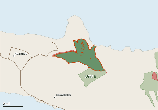
This unitUnit landOther public hunting areaSafety zone or no huntingHighway
| Island | Molokaʻi |
|---|---|
| Size | 4,386 acres (2.6% of the island) |
| Game mammals | feral pigs and feral goats |
| Game birds | Open (bird unit C, D) |
| Open periods | February through October |
| Open days | Saturdays, Sundays, and State Holidays |
| Safety zones and closed areas | 2 in or touching the unit |
| Nearest towns | Kaunakakai (3.7 mi), Kualapuu (3.9 mi) and Ualapue (7.1 mi) |
What are the hunting rules in Molokai Units C and D?
DLNR's rule for Units C and D, row by row, in its own words.
| Game | Means of take | Bag limit | Open period | Open days | Conditions |
|---|---|---|---|---|---|
| Feral pigs and feral goats | Rifles, shotguns, & archery. Dogs permitted.* | Two goats and two pigs per day. No season limit. | February through October | Saturdays, Sundays, and State Holidays | Handgun permitted for hunting pigs with or without dogs |
Source: HAR 13-123, Molokai exhibit; HAR Chapter 13-123. Footnote marks (*, **) refer to the exhibit's own notes.
What land makes up Molokai Units C and D?
| Section | Acres | Status in the GIS layer |
|---|---|---|
| Portions of Molokai F.R. within Kalawao county | 1,521 | Hunting Area (Mammal and Bird) |
| Portions of Molokai F.R. | 2,865 | Hunting Area (Mammal and Bird) |
Source: Hawaii Statewide GIS Program, Hunting Areas (from HAR 13-122 and 13-123; closures after the 2015 rules are marked, later additions may not be). Acres: the layer's own.
Where can't you hunt in or near Units C and D?
- 500-foot wide Safety Zone: Safety Zone (NO HUNTING) (159 acres)
- Sandal Wood Pit 500-foot wide Safety Zone: Safety Zone (NO HUNTING) (5 acres)
Safety zones and no hunting areas from the same GIS layer. Signs on the ground and DLNR's rules come first.
Which towns and roads are near Molokai Units C and D?
Nearest Census places: Kaunakakai (3.7 miles), Kualapuu (3.9 miles), Ualapue (7.1 miles) and Maunaloa (13.6 miles). No state or federal highway comes within a mile.
Towns and highways: U.S. Census Bureau TIGER/Line and Gazetteer 2024.
License, stamp and hunter education rules: see Hawaii hunting.
Questions hunters ask
What can you hunt in Molokai Units C and D?
Feral pigs and feral goats, by DLNR's exhibit of HAR 13-123 for Molokai.
What is the bag limit in Molokai Units C and D?
Feral pigs and feral goats: Two goats and two pigs per day. No season limit. DLNR's rules are the final word.
When is Molokai Units C and D open?
Feral pigs and feral goats: February through October; Saturdays, Sundays, and State Holidays. By DLNR's rule.
How big is Molokai Units C and D?
4,386 acres, 32.4% of Molokai's public hunting land, in the Hawaii Statewide GIS Program's hunting areas layer: Portions of Molokai F.R. within Kalawao county (1,521 acres) and Portions of Molokai F.R. (2,865 acres).
Are there closed areas or safety zones in Molokai Units C and D?
Yes. The GIS layer marks 2 safety zone or no hunting areas in or touching the unit, including 500-foot wide Safety Zone and Sandal Wood Pit 500-foot wide Safety Zone.
Get a Hawaii hunt plan when they open
Hawaii plans are not open yet. They are coming soon. Join the waiting list; the first 50 hunters get one plan free.
Use the map while you wait for your plan.
Where these facts come from
- Rules: DLNR exhibits of HAR 13-123 and HAR 13-122, from DLNR's Molokai hunting page.
- Units, sections and acres: Hawaii Statewide GIS Program, Hunting Areas. Towns and highways: U.S. Census Bureau.
FilledTag is not part of the Hawaii Department of Land and Natural Resources.
Hawaii hunting Molokaʻi hunting Molokai Units A and B Molokai Unit E