Clayton County, Iowa: deer harvest and public hunting land
Clayton County covers 793 square miles around Guttenberg. Hunters reported 4,248 deer here in the 2025 season, 1,527 of them antlered bucks, through the DNR's harvest reporting. That is down 2% from 2024. 4.6% of Clayton County is public land open to the public, the largest share public hunting areas on the DNR atlas (16,939 acres), by USGS PAD-US 4.1 and the DNR's public hunting area boundaries.
Data updated October 2026. Harvest: the DNR's harvest reporting results, 2021 to 2025. Land: PAD-US 4.1 and the DNR's Hunting Atlas layer.
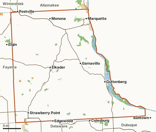
Public hunting areas on the DNR atlasNational wildlife refuges and waterfowl production areasFederal land, mostly Corps of Engineers lakesOther DNR landState parks and recreation areasCounty conservation board and city landIHAP landClayton CountyNeighboring countiesLakeHighway
| Size | 507,369 acres (793 square miles) |
|---|---|
| Deer reported, 2025 | 4,248 (1,527 antlered bucks, 275 button bucks, 2,371 does and doe fawns) |
| Deer zone (2026) | Zone A |
| Public land | 4.6% (23,270 acres) |
| Hunting areas | 20 (16,936 acres inside Clayton County) |
| IHAP land | 4 sites, 570 acres |
| Towns in and near it | Guttenberg, Strawberry Point, Marquette, Edgewood, Postville and Colesburg |
How many deer are harvested in Clayton County?
Hunters reported 4,248 deer in Clayton County in 2025: 1,527 antlered bucks, 275 button bucks, 2,371 does and doe fawns and 75 bucks that had shed their antlers.
| Season | Deer reported | Antlered bucks | Button bucks | Does | Doe fawns | Shed-antler bucks |
|---|---|---|---|---|---|---|
| 2025 | 4,248 | 1,527 | 275 | 2,250 | 121 | 75 |
| 2024 | 4,324 | 1,635 | 315 | 2,189 | 117 | 68 |
| 2023 | 4,023 | 1,534 | 324 | 1,999 | 123 | 43 |
| 2022 | 4,137 | 1,469 | 318 | 2,201 | 90 | 59 |
| 2021 | 3,924 | 1,512 | 329 | 1,966 | 80 | 37 |
Source: Iowa DNR harvest reporting (2021 to 2025 seasons), Clayton County. Every county's numbers add up to the DNR's statewide row for each season shown.
How much public land is in Clayton County?
23,270 of Clayton County's 507,369 acres are public land open to the public (4.6%). The biggest share is public hunting areas on the DNR atlas: 16,939 acres.
| Manager | Acres | Share of Clayton County |
|---|---|---|
| Public hunting areas on the DNR atlas | 16,939 | 3.3% |
| National wildlife refuges and waterfowl production areas | 2,146 | 0.4% |
| Other DNR land | 1,646 | 0.3% |
| State parks and recreation areas | 1,053 | 0.2% |
| County conservation board and city land | 764 | 0.2% |
| Federal land, mostly Corps of Engineers lakes | 722 | 0.1% |
| All public land open to the public | 23,270 | 4.6% |
Measured by FilledTag inside the county line from USGS PAD-US 4.1 (fee land open to the public) and the DNR's public hunting area boundaries. Hunting rules differ by manager: DNR wildlife management areas and state forests are open to hunting unless posted as a refuge; Corps of Engineers lake land is open in many places under each project's own rules; national wildlife refuges and waterfowl production areas follow U.S. Fish and Wildlife Service rules; county conservation boards set the rules on their own land; state parks are closed to most hunting.
Public hunting areas in Clayton County
Public hunting areas in Clayton County, largest first, with the acres of each inside it:
- Upper Mississippi River Fish & Wildlife Refuge: 11,316 acres
- North Cedar/Sny Magill Wildlife Area: 1,950 acres
- Bloody Run Wildlife Area: 1,112 acres
- Leonard Wildlife Area: 335 acres
- Volga River Wildlife Area: 256 acres
- Becker East: 253 acres
- Driftless Area National Wildlife Refuge - Howard Creek Unit: 214 acres
- Driftless Area National Wildlife Refuge - Fern Ridge Unit: 205 acres
- Becker West: 172 acres
- Cow Branch Wildlife Area: 165 acres
- Klingman Etringer Wildlife Area: 159 acres
- Driftless Area National Wildlife Refuge - Pine Creek Unit: 141 acres
- Big Springs Wildlife Area: 119 acres
- Ensign Hollow Wildlife Area: 118 acres
- Buck Creek Park: 97 acres
- Pleasant Ridge: 84 acres
- Mossey Glen Wildlife Area: 78 acres
- Motor Mill Access: 76 acres
- Joy Springs Wildlife Area: 72 acres
- Roberts Creek Wildlife Area: 14 acres
Other large public areas here, by PAD-US: Upper Mississippi River National Wildlife And Fish Refuge (5,126 acres), Ms Rv Pools 11-22 Recreation Area (2,424 acres), Driftless Area National Wildlife Refuge (866 acres) and Effigy Mounds National Monument (515 acres).
IHAP land in Clayton County
The DNR's IHAP layer shows 4 tracts in Clayton County, 570 acres of private land leased for walk-in hunting. Nearly every tract is walk-in only, September 1 to May 31, by the DNR's notes. DNR: IHAP.
How do you get to Clayton County?
Highways through it: US 52 (about 46 miles inside), IA 13 (about 32 miles inside), US 18 (about 24 miles inside), IA 56 (about 12 miles inside) and IA 3 (about 10 miles inside). Towns inside: Guttenberg, Strawberry Point, Marquette, Elkader, Monona and McGregor. Nearby: Edgewood (on the line), Postville (on the line), Colesburg (on the line) and Elgin (on the line).
Which counties border Clayton County?
Clayton County touches 6 other counties. Their latest DNR harvest and public land, for comparison:
| County | Deer harvested | Year | Public land | IHAP land sites |
|---|---|---|---|---|
| Dubuque County | 2,390 | 2025 | 3.1% | 1 |
| Fayette County | 2,128 | 2025 | 1.8% | 5 |
| Buchanan County | 1,032 | 2025 | 1.1% | 1 |
| Delaware County | 1,732 | 2025 | 1.7% | |
| Allamakee County | 3,498 | 2025 | 10.8% | 1 |
| Winneshiek County | 2,519 | 2025 | 2.3% | 5 |
Questions hunters ask
How many deer were harvested in Clayton County in 2025?
Hunters reported 4,248 deer: 1,527 antlered bucks, 275 button bucks and 2,371 does and doe fawns (DNR). In 2024: 4,324.
Is there public hunting land in Clayton County?
Yes. 23,270 acres, 4.6% of the county, are public land open to the public by USGS PAD-US 4.1 and the DNR's public hunting area boundaries, the largest share public hunting areas on the DNR atlas (16,939 acres). The DNR's atlas shows 20 public hunting areas here.
Does Clayton County have IHAP land?
Yes. 4 tracts, 570 acres, on the DNR's IHAP layer.
Get a Iowa hunt plan when they open
Hunt plans for Iowa are coming. Join the list and you'll hear first. The first 50 hunters in each new state get their plan free.
Until then, the free FilledTag app for iPhone has a map that works in every state, Iowa included.
Where these numbers come from
- Deer harvest: Iowa DNR harvest reporting (2021 to 2025 seasons).
- Public land: USGS PAD-US 4.1 (fee land open to the public) and the DNR's public hunting area boundaries. public hunting areas: Iowa DNR public hunting areas (Hunting Atlas layer). IHAP land: Iowa DNR Iowa Habitat and Access Program (IHAP) tracts.
- Boundaries: U.S. Census Bureau 2024 cartographic county boundaries. Highways and towns: U.S. Census Bureau TIGER/Line 2024 primary and secondary roads; U.S. Census Bureau 2024 Gazetteer, places.
FilledTag is not part of the Iowa Department of Natural Resources. Numbers are copied from the DNR and the federal sources above, or measured from their maps; nothing on this page is estimated by FilledTag.
Iowa hunting Dubuque County Fayette County Buchanan County Delaware County Allamakee County Winneshiek County