Harrison County, Iowa: deer harvest and public hunting land
Harrison County covers 701 square miles around Missouri Valley. Hunters reported 532 deer here in the 2025 season, 344 of them antlered bucks, through the DNR's harvest reporting. That is up 6% from 2024. 3.9% of Harrison County is public land open to the public, the largest share public hunting areas on the DNR atlas (13,809 acres), by USGS PAD-US 4.1 and the DNR's public hunting area boundaries.
Data updated October 2026. Harvest: the DNR's harvest reporting results, 2021 to 2025. Land: PAD-US 4.1 and the DNR's Hunting Atlas layer.
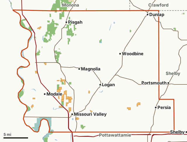
Public hunting areas on the DNR atlasNational wildlife refuges and waterfowl production areasFederal land, mostly Corps of Engineers lakesState parks and recreation areasCounty conservation board and city landIHAP landHarrison CountyNeighboring countiesLakeHighway
| Size | 448,896 acres (701 square miles) |
|---|---|
| Deer reported, 2025 | 532 (344 antlered bucks, 32 button bucks, 154 does and doe fawns) |
| Deer zone (2026) | Zone A |
| Public land | 3.9% (17,489 acres) |
| Hunting areas | 33 (13,810 acres inside Harrison County) |
| IHAP land | 15 sites, 3,967 acres |
| Towns in and near it | Missouri Valley, Woodbine, Dunlap, Portsmouth, Shelby and Minden |
How many deer are harvested in Harrison County?
Hunters reported 532 deer in Harrison County in 2025: 344 antlered bucks, 32 button bucks, 154 does and doe fawns and 2 bucks that had shed their antlers.
| Season | Deer reported | Antlered bucks | Button bucks | Does | Doe fawns | Shed-antler bucks |
|---|---|---|---|---|---|---|
| 2025 | 532 | 344 | 32 | 148 | 6 | 2 |
| 2024 | 500 | 329 | 17 | 148 | 2 | 4 |
| 2023 | 738 | 390 | 74 | 255 | 12 | 7 |
| 2022 | 840 | 405 | 54 | 365 | 12 | 4 |
| 2021 | 913 | 432 | 85 | 374 | 19 | 3 |
Source: Iowa DNR harvest reporting (2021 to 2025 seasons), Harrison County. Every county's numbers add up to the DNR's statewide row for each season shown.
How much public land is in Harrison County?
17,489 of Harrison County's 448,896 acres are public land open to the public (3.9%). The biggest share is public hunting areas on the DNR atlas: 13,809 acres.
| Manager | Acres | Share of Harrison County |
|---|---|---|
| Public hunting areas on the DNR atlas | 13,809 | 3.1% |
| National wildlife refuges and waterfowl production areas | 3,289 | 0.7% |
| Federal land, mostly Corps of Engineers lakes | 217 | under 0.1% |
| County conservation board and city land | 90 | under 0.1% |
| Other DNR land | 70 | under 0.1% |
| State parks and recreation areas | 14 | under 0.1% |
| All public land open to the public | 17,489 | 3.9% |
Measured by FilledTag inside the county line from USGS PAD-US 4.1 (fee land open to the public) and the DNR's public hunting area boundaries. Hunting rules differ by manager: DNR wildlife management areas and state forests are open to hunting unless posted as a refuge; Corps of Engineers lake land is open in many places under each project's own rules; national wildlife refuges and waterfowl production areas follow U.S. Fish and Wildlife Service rules; county conservation boards set the rules on their own land; state parks are closed to most hunting.
Public hunting areas in Harrison County
Public hunting areas in Harrison County, largest first, with the acres of each inside it:
- Loess Hills State Forest - Little Sioux Unit: 3,768 acres
- Loess Hills State Forest - Pisgah Unit: 2,600 acres
- Loess Hills State Forest - Mondamin Unit: 1,096 acres
- Loess Hills State Forest - Preparation Canyon Unit: 953 acres
- Tyson Bend Wildlife Area: 809 acres
- Deer Island Wildlife Area: 802 acres
- California Bend Wildlife Area: 466 acres
- Round Lake Wildlife Area: 435 acres
- Old Town Conservation Area: 345 acres
- Three Rivers Wildlife Area: 316 acres
- Soldier Bend Wildlife Area: 295 acres
- Vaile Wetland Nature Area: 281 acres
- Missouri Bottoms Wetland Area: 240 acres
- Willow Lake Recreation Area: 219 acres
- Little Sioux Bend: 168 acres
- Gleason-Hubel Wildlife Area: 163 acres
- Nolan Wetland Area: 160 acres
- Sawmill Hollow Wildlife Area: 159 acres
- Nobles Lake Wildlife Area: 122 acres
- Schaben Park: 77 acres
- Rand Bar Wildlife Area: 65 acres
- Saint John's Wildlife Area: 55 acres
- Upper Bullard Bend Wildlife Area: 36 acres
- Mondamin Wildlife Area: 33 acres
- Gee-Hruska Wetland Area: 32 acres
- Fawn Island: 20 acres
- Lower Bullard Bend Wildlife Area: 19 acres
- O'Day Wetland Restoration: 19 acres
- Fish Lake Wildlife Area: 15 acres
- Ruffcorn Wildlife Area: 15 acres
- Rand Access: 11 acres
- Sioux Dam Wildlife Area: 9 acres
- Missouridale Wildlife Area: 7 acres
Other large public areas here, by PAD-US: Desoto National Wildlife Refuge (3,291 acres).
IHAP land in Harrison County
The DNR's IHAP layer shows 15 tracts in Harrison County, 3,967 acres of private land leased for walk-in hunting. Nearly every tract is walk-in only, September 1 to May 31, by the DNR's notes. DNR: IHAP.
How do you get to Harrison County?
Highways through it: I-29 (about 57 miles inside), US 30 (about 39 miles inside), IA 183 (about 28 miles inside), IA 127 (about 16 miles inside) and IA 44 (about 9 miles inside). Towns inside: Missouri Valley, Woodbine, Dunlap, Logan, Modale and Magnolia. Nearby: Portsmouth (2 miles), Shelby (3 miles), Minden (3 miles) and Tennant (3 miles).
Which counties border Harrison County?
Harrison County touches 4 other counties. Their latest DNR harvest and public land, for comparison:
| County | Deer harvested | Year | Public land | IHAP land sites |
|---|---|---|---|---|
| Monona County | 452 | 2025 | 4% | 8 |
| Shelby County | 142 | 2025 | 0.5% | |
| Crawford County | 245 | 2025 | 0.4% | 2 |
| Pottawattamie County | 530 | 2025 | 1.1% | 1 |
Questions hunters ask
How many deer were harvested in Harrison County in 2025?
Hunters reported 532 deer: 344 antlered bucks, 32 button bucks and 154 does and doe fawns (DNR). In 2024: 500.
Is there public hunting land in Harrison County?
Yes. 17,489 acres, 3.9% of the county, are public land open to the public by USGS PAD-US 4.1 and the DNR's public hunting area boundaries, the largest share public hunting areas on the DNR atlas (13,809 acres). The DNR's atlas shows 33 public hunting areas here.
Does Harrison County have IHAP land?
Yes. 15 tracts, 3,967 acres, on the DNR's IHAP layer.
Get a Iowa hunt plan when they open
Hunt plans for Iowa are coming. Join the list and you'll hear first. The first 50 hunters in each new state get their plan free.
Until then, the free FilledTag app for iPhone has a map that works in every state, Iowa included.
Where these numbers come from
- Deer harvest: Iowa DNR harvest reporting (2021 to 2025 seasons).
- Public land: USGS PAD-US 4.1 (fee land open to the public) and the DNR's public hunting area boundaries. public hunting areas: Iowa DNR public hunting areas (Hunting Atlas layer). IHAP land: Iowa DNR Iowa Habitat and Access Program (IHAP) tracts.
- Boundaries: U.S. Census Bureau 2024 cartographic county boundaries. Highways and towns: U.S. Census Bureau TIGER/Line 2024 primary and secondary roads; U.S. Census Bureau 2024 Gazetteer, places.
FilledTag is not part of the Iowa Department of Natural Resources. Numbers are copied from the DNR and the federal sources above, or measured from their maps; nothing on this page is estimated by FilledTag.
Iowa hunting Monona County Shelby County Crawford County Pottawattamie County