Dix River WMA: deer harvest, 2026-27 rules and access
Dix River WMA is 401 acres of public hunting land in Lincoln County, in KDFWR's Southeast region. Hunters telechecked 13 deer on the area in the 2025-26 season, 3 antlered bucks among them. KDFWR's 2026-27 rule for the area: Open under statewide rules and regulations in effect for the county.
Data updated October 2026. Rules: KDFWR's page for the area. Harvest: KDFWR Telecheck reports, 2016-17 to 2025-26.
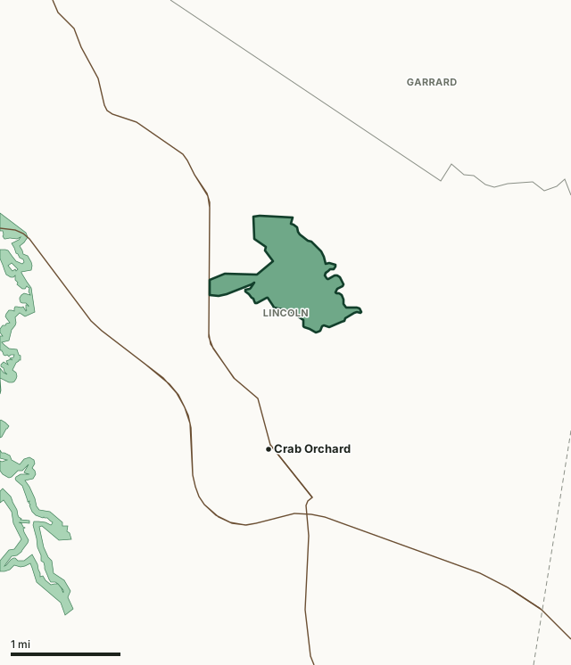
Dix River WMAOther KDFWR public hunting areasLake or riverHighwayCounty line
| Size | 401 acres (KDFWR) |
|---|---|
| County | Lincoln County |
| KDFWR region | Southeast region |
| Deer zone of the county | Zone 2 |
| Deer telechecked, 2025-26 | 13 (3 antlered bucks, 9 does) |
| Elevation | Minimum 844 feet, maximum 880 feet |
| Contact | (270)283-0244 |
| Nearest towns | Crab Orchard (next to it), Brodhead (6 mi) and Stanford (8 mi) |
What are the 2026-27 hunting rules on Dix River WMA?
KDFWR lists these rules for the area. Where it says the area is open under statewide seasons, the county's zone rules apply.
Fall Hunting Season
- Open under statewide rules and regulations in effect for the county.
Exceptions
- Closed for modern gun deer season.
- Rabbit and quail seasons open Nov. 1-Dec. 31, except during the opening weekend of modern gun deer season.
- Grouse season open Oct. 1-Dec. 31.
- The CWD Antlerless Season (Sept. 25-28) is open on Dix River WMA.
Source: KDFWR's page for Dix River WMA, read October 2026. Statewide seasons: 2026-27 Kentucky Hunting and Trapping Guide, page 10.
How many deer are taken on Dix River WMA?
Hunters telechecked 13 deer on Dix River WMA in the 2025-26 season: 3 antlered bucks, 1 button buck and 9 does. Over the 10 seasons KDFWR reports, the area averaged 6 deer a season, from 4 in 2022-23 to 13 in 2025-26.
| Season | Deer telechecked | Antlered bucks | Does | Firearms | Archery | Crossbow | Muzzleloader |
|---|---|---|---|---|---|---|---|
| 2025-26 | 13 | 3 | 9 | 2 | 3 | 4 | 4 |
| 2024-25 | 6 | 2 | 4 | 0 | 3 | 3 | 0 |
| 2023-24 | 6 | 2 | 3 | 1 | 3 | 0 | 2 |
| 2022-23 | 4 | 1 | 3 | 0 | 4 | 0 | 0 |
| 2021-22 | 5 | 1 | 4 | 0 | 3 | 1 | 1 |
| 2020-21 | 4 | 1 | 3 | 0 | 2 | 1 | 1 |
| 2019-20 | 6 | 3 | 3 | 2 | 4 | 0 | 0 |
| 2018-19 | 4 | 1 | 3 | 0 | 1 | 0 | 3 |
| 2017-18 | 5 | 1 | 3 | 1 | 3 | 1 | 0 |
| 2016-17 | 5 | 4 | 1 | 0 | 3 | 1 | 1 |
Source: KDFWR Harvest Data (Telecheck), deer by public land. Antlered bucks are KDFWR's count of males with visible antlers; the rest of the males are button bucks.
Spring turkey telechecked on the area: 2 in 2024, 4 in 2022, 4 in 2021 and 1 in 2020 (KDFWR Harvest Data, spring season).
What kind of ground is Dix River WMA?
KDFWR describes the area's habitat as 66.08% open land, 17.71% forest and 15.96% wetland. Elevation runs from 844 feet to 880 feet.
Which county is Dix River WMA in?
| County | Acres of the area in it | Deer zone | County deer, 2025-26 | Rank of 120 |
|---|---|---|---|---|
| Lincoln County | 401 | 2 | 1,491 | 38th |
Acres measured by FilledTag on KDFWR public hunting area boundaries and the U.S. Census Bureau 2024 county boundaries. County harvest: KDFWR Harvest Data (Telecheck), deer by county. Zones: KDFWR current deer zones.
How do you get to Dix River WMA?
From Stanford travel approximately 10 miles east on US 150; turn left on KY 39 and travel 1.75 miles to WMA on right; or turn right on KY 3246 (Falls Lick RD) and travel 2/3 mile to parking area on the right. Directions from Mount Vernon – travel approximately 14 miles west on KY150; right on KY 39 for travel 1.75 miles to WMA on right; or turn right on KY 3246 (Falls Lick RD) and travel 2/3 mile to parking area on the right. Dix River WMA is located in east central Lincoln County and consists of the 400 acres. The topography consists of flat bottomlands and the majority of the property is bounded by Dix River and Mud Lick Creek. Approximately 120 acres are forested and 280 acres are in an open condition. Elevations range from 850 to 880 feet above sea level. Good to moderate populations of squirrel, rabbits and songbirds exist on the area. The area is open under statewide regulations for small game, turkey, and deer seasons with the exception of modern gun deer season. See the Fall Hunting and Trapping Guide for additional information concerning hunting seasons. Owned by the Kentucky Department of Fish and Wildlife.
From KDFWR's page for the area.
Highways within 5 miles: KY 39, US 150, KY 3246 and KY 1972. Nearest towns: Crab Orchard (next to it), Brodhead (6 miles), Stanford (8 miles) and Lancaster (10 miles).
The closest other public hunting areas with a page here: Cedar Creek Lake WMA (1.6 miles), Daniel Boone National Forest (11.9 miles), Miller Welch-Central Kentucky WMA (17.4 miles) and Blue Grass Army Depot (18 miles).
Questions hunters ask
When can you hunt Dix River WMA in 2026-27?
KDFWR's 2026-27 rules for Dix River WMA: Open under statewide rules and regulations in effect for the county.
How many deer were killed on Dix River WMA last season?
Hunters telechecked 13 deer on Dix River WMA in the 2025-26 season: 3 antlered bucks and 9 does. The most taken with crossbow (4).
What county is Dix River WMA in?
All of it is in Lincoln County, by KDFWR's boundary.
What deer zone is Dix River WMA in?
Lincoln County is in Zone 2. Up to four deer. Area rules can be stricter than the zone's, as listed above.
Get a Kentucky hunt plan when they open
Hunt plans for Kentucky are coming. Join the list and you'll hear first. The first 50 hunters in each new state get their plan free.
Until then, the free FilledTag app for iPhone has a map that works in every state, Kentucky included.
Where these numbers come from
- Area rules, size, habitat, contact and directions: KDFWR, Dix River WMA.
- Deer, elk and turkey harvest on the area: KDFWR Harvest Data (Telecheck), deer by public land. County harvest: KDFWR Harvest Data (Telecheck), deer by county.
- Boundary: KDFWR public hunting area boundaries. Counties, highways and towns: U.S. Census Bureau 2024 county boundaries; U.S. Census Bureau TIGER/Line 2024 roads; U.S. Census Bureau 2024 Gazetteer. National forest and refuges: U.S. Forest Service national forest ownership; U.S. Fish and Wildlife Service refuge boundaries.
FilledTag is not part of Kentucky Fish and Wildlife. Numbers are copied from KDFWR or measured from public maps; nothing on this page is estimated by FilledTag.
Kentucky hunting All Kentucky WMAs Lincoln County deer harvest