Peabody WMA: deer harvest, 2026-27 rules and access
Peabody WMA is 40,744 acres of public hunting land in Muhlenberg, Ohio and Hopkins counties, in KDFWR's Green River region. Hunters telechecked 575 deer on the area in the 2025-26 season, 216 antlered bucks among them. KDFWR's 2026-27 rule for the area: Open under statewide rules and regulations in effect for the county.
Data updated October 2026. Rules: KDFWR's page for the area. Harvest: KDFWR Telecheck reports, 2016-17 to 2025-26.
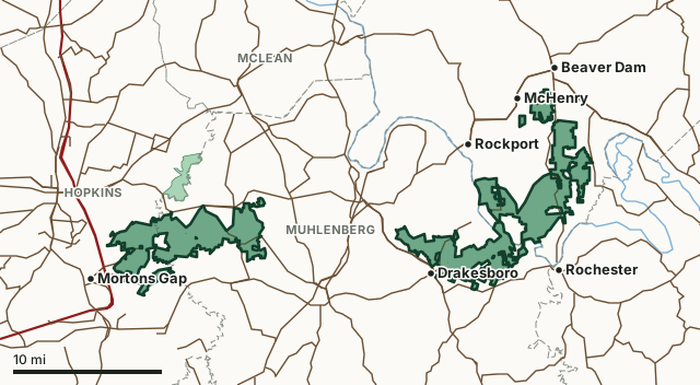
Peabody WMAOther KDFWR public hunting areasLake or riverHighwayCounty line
| Size | 40,744 acres (KDFWR) |
|---|---|
| County | Muhlenberg County, Ohio County, Hopkins County |
| KDFWR region | Green River region |
| Deer zone of the county | Zone 1 |
| Deer telechecked, 2025-26 | 575 (216 antlered bucks, 307 does) |
| Elevation | Minimum 324 feet, maximum 654 feet |
| Contact | Office (270) 476-1889 |
| Nearest towns | Drakesboro (next to it), McHenry (next to it) and Beaver Dam (2 mi) |
What are the 2026-27 hunting rules on Peabody WMA?
KDFWR lists these rules for the area. Where it says the area is open under statewide seasons, the county's zone rules apply.
Fall Hunting Season
- Any person age 16 and older entering the area must obtain and carry a Peabody WMA user permit. Individual permits may be obtained through any license vendor. Permits are nontransferable. Rabbit and quail hunters on the Sinclair and Ken units must check in and check out at self-service kiosk and clearly display a department-provided vehicle hang-tag in a vehicle. Hang-tags available in advance through the department's website.
- Open under statewide rules and regulations in effect for the county.
Exceptions
- Modern gun deer season is open under statewide regulations for 10 consecutive days starting the second Saturday in November. The season is closed after that.
- On the Sinclair Unit, quail hunting is allowed between 7:30 a.m. - 3 p.m. on Thursdays and Sundays; On the Ken Unit, quail hunting is allowed between 7:30 a.m. - 3 p.m. on Wednesdays and Saturdays. On either unit, the daily bag limit for quail is four.
Shooting Range
- A person shall not target practice, sight in a firearm, or discharge a firearm in any area except the shooting range. Shooting multiple projectile shells is not permitted on Tube Ranges. Club Ranges are off-limits unless authorized by an approved event with a club range safety officer. A person shall not discharge a firearm within 100 yards of a residence or occupied building, whether or not the building is on the WMA.
- Not allowed at the range:
- Damage a tree or shrub (No installation of targets on trees or shrubs)
- Dump trash or litter (Clean up targets and spent shells)
- Deface or destroy a signs
- Pose a risk to persons or property (Shooters responsible for ensuring adequate backstop)
- Engage in an activity which could unreasonably interfere with other uses or users of the area
ADA Acreage
- 6,500 Acres.
Source: KDFWR's page for Peabody WMA, read October 2026. Statewide seasons: 2026-27 Kentucky Hunting and Trapping Guide, page 10.
How many deer are taken on Peabody WMA?
Hunters telechecked 575 deer on Peabody WMA in the 2025-26 season: 216 antlered bucks, 52 button bucks and 307 does. Over the 10 seasons KDFWR reports, the area averaged 708 deer a season, from 575 in 2025-26 to 842 in 2019-20.
| Season | Deer telechecked | Antlered bucks | Does | Firearms | Archery | Crossbow | Muzzleloader |
|---|---|---|---|---|---|---|---|
| 2025-26 | 575 | 216 | 307 | 416 | 73 | 35 | 51 |
| 2024-25 | 617 | 236 | 315 | 457 | 70 | 27 | 63 |
| 2023-24 | 691 | 281 | 333 | 491 | 92 | 47 | 61 |
| 2022-23 | 809 | 306 | 416 | 609 | 78 | 45 | 77 |
| 2021-22 | 692 | 246 | 338 | 496 | 79 | 45 | 72 |
| 2020-21 | 698 | 283 | 336 | 507 | 71 | 49 | 71 |
| 2019-20 | 842 | 313 | 428 | 668 | 83 | 36 | 55 |
| 2018-19 | 805 | 324 | 397 | 653 | 59 | 11 | 82 |
| 2017-18 | 662 | 278 | 317 | 516 | 66 | 14 | 66 |
| 2016-17 | 692 | 305 | 325 | 575 | 64 | 13 | 40 |
Source: KDFWR Harvest Data (Telecheck), deer by public land. Antlered bucks are KDFWR's count of males with visible antlers; the rest of the males are button bucks.
Spring turkey telechecked on the area: 117 in 2025, 135 in 2024, 126 in 2023 and 143 in 2022 (KDFWR Harvest Data, spring season).
What kind of ground is Peabody WMA?
KDFWR describes the area's habitat as 59.85% forest, 22.76% open land, 13.46% wetland and 3.93% open water. Elevation runs from 324 feet to 654 feet.
Which county is Peabody WMA in?
| County | Acres of the area in it | Deer zone | County deer, 2025-26 | Rank of 120 |
|---|---|---|---|---|
| Muhlenberg County | 20,291 | 1 | 1,986 | 17th |
| Ohio County | 15,141 | 1 | 1,878 | 20th |
| Hopkins County | 5,315 | 1 | 2,486 | 10th |
Acres measured by FilledTag on KDFWR public hunting area boundaries and the U.S. Census Bureau 2024 county boundaries. County harvest: KDFWR Harvest Data (Telecheck), deer by county. Zones: KDFWR current deer zones.
How do you get to Peabody WMA?
WMA consists of numerous separated tracts located along Wendell H Ford PKWY, between Edward T Breathitt PKWY (Pennyrile) west to William H Natcher PKWY east. Access points include KY 70, KY 369, KY 176, KY 269 and US 62. Sinclair tract contains a waterfowl refuge around Goose Lake that is closed from Oct. 15-March 15. In Ohio County the waterfowl refuge around South and Island lakes is also closed from Oct. 15-March 15. Rough terrain from swampland to high ridges and deep pits; primarily reclaimed coal-mined land with numerous excavated ridges and water-filled strip mine pits (visitors should be wary). Excellent birding and fishing opportunities. Good deer, turkey, waterfowl and small game hunting. One of the better areas for quail hunting in the state. Horseback riding allowed on maintained roads. Shooting range (for single projectile firearms only; no shotshells or pistols allowed) open Tuesday - Saturday 9:00 AM - Sunset & Sundays Noon - Sunset. Check online calendar or call area office for closures or events. Mobility impaired access to permit holders in designated area, which is currently the Sinclair unit. A user permit ($15.00) required to enter the area for any type of use, can be purchased wherever Kentucky hunting and fishing licenses are sold. Upland Bird and Rabbit Hunters MUST check in/out at Kiosks using HangTag (last page of map document) Owned/leased by Kentucky Department of Fish and Wildlife Resources.
From KDFWR's page for the area.
Highways through the area: KY 176, KY 175, KY 369 and KY 601. Nearest towns: Drakesboro (next to it), McHenry (next to it), Beaver Dam (2 miles) and Mortons Gap (2 miles).
The closest other public hunting areas with a page here: Harris-Dickerson WMA (next to it), Clear Creek WMA (12.9 miles), Pennyrile State Forest (13.3 miles) and Tradewater WMA (13.6 miles).
Questions hunters ask
When can you hunt Peabody WMA in 2026-27?
KDFWR's 2026-27 rules for Peabody WMA: Any person age 16 and older entering the area must obtain and carry a Peabody WMA user permit. Individual permits may be obtained through any license vendor. Permits are nontransferable. Rabbit and quail hunters on the Sinclair and Ken units must check in and check out at self-service kiosk and clearly display a department-provided vehicle hang-tag in a vehicle. Hang-tags available in advance through the department's website. Open under statewide rules and regulations in effect for the county.
How many deer were killed on Peabody WMA last season?
Hunters telechecked 575 deer on Peabody WMA in the 2025-26 season: 216 antlered bucks and 307 does. The most taken with firearms (416).
What county is Peabody WMA in?
Muhlenberg County (20,291 acres), Ohio County (15,141 acres) and Hopkins County (5,315 acres), measured on KDFWR's boundary.
What deer zone is Peabody WMA in?
Muhlenberg County is in Zone 1, Ohio County is in Zone 1 and Hopkins County is in Zone 1. Unlimited number of antlerless deer using the statewide deer permit plus additional deer permits. Area rules can be stricter than the zone's, as listed above.
Get a Kentucky hunt plan when they open
Hunt plans for Kentucky are coming. Join the list and you'll hear first. The first 50 hunters in each new state get their plan free.
Until then, the free FilledTag app for iPhone has a map that works in every state, Kentucky included.
Where these numbers come from
- Area rules, size, habitat, contact and directions: KDFWR, Peabody WMA.
- Deer, elk and turkey harvest on the area: KDFWR Harvest Data (Telecheck), deer by public land. County harvest: KDFWR Harvest Data (Telecheck), deer by county.
- Boundary: KDFWR public hunting area boundaries. Counties, highways and towns: U.S. Census Bureau 2024 county boundaries; U.S. Census Bureau TIGER/Line 2024 roads; U.S. Census Bureau 2024 Gazetteer. National forest and refuges: U.S. Forest Service national forest ownership; U.S. Fish and Wildlife Service refuge boundaries.
FilledTag is not part of Kentucky Fish and Wildlife. Numbers are copied from KDFWR or measured from public maps; nothing on this page is estimated by FilledTag.
Kentucky hunting All Kentucky WMAs Muhlenberg County deer harvest Ohio County deer harvest Hopkins County deer harvest