Maj. Gregory Sanborn (Brownfield Bog) Wildlife Management Area: hunting, access and rules
Maj. Gregory Sanborn (Brownfield Bog) Wildlife Management Area is 5,827 acres of Maine Department of Inland Fisheries and Wildlife land in Brownfield and Fryeburg, inside WMD 15. MDIFW lists 5 access points for it. Hunting is allowed, with MDIFW's rules for its WMAs.
Data updated October 2026. Boundary and access points: MDIFW's WMA layers. Seasons: MDIFW 2026-27 Maine hunting seasons.
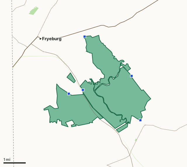
State public lands and parks (BPL)MDIFW land (WMAs)Other state landMaj. Gregory Sanborn (Brownfield Bog) WMAMDIFW access pointWMD lineHighway
| Size | 5,827 acres (MDIFW) |
|---|---|
| Towns (MDIFW) | Brownfield, Fryeburg |
| Wildlife Management District | WMD 15 |
| MDIFW region | Region A |
| Access points | 5 |
| What MDIFW lists to do here | Walking, Boating, Canoeing, Wildlife Watching (Eagles and Osprey, Deer, and Water Birds), Hunting (Big Game, Small Game, Upland Game, Waterfowl), Trapping, Fishing (Cold and Warm Water Species), Ice Fishing |
| Not allowed (MDIFW) | Camping, fires, and swimming are prohibited. |
| Nearest towns | Fryeburg (2 mi), Bridgton (10 mi) and Kezar Falls (11 mi) |
Where do you get into Maj. Gregory Sanborn (Brownfield Bog) WMA?
MDIFW lists 5 access points for Maj. Gregory Sanborn (Brownfield Bog) WMA:
| Point | Where (MDIFW) | Latitude, longitude | Directions (MDIFW) |
|---|---|---|---|
| 1 | Boat Launch Road, Fryeburg | 43.98715, -70.93232 | There is a public boat launch on Lovewell Pond that can be reached by turning onto a gravel road (Fire Lane 14/Boat Launch Road) off Route 113 in Fryeburg. |
| 2 | Clays Pond Road, Brownfield | 43.98460, -70.94510 | Follow Route 113 south from Fryeburg and then turn west onto Lyman Drive. Bear left onto the Clay Pond Road. |
| 3 | Bog Road, Brownfield | 43.96803, -70.87960 | Follow Route 160 north from Denmark. Continue onto Lords Hill Road, then turn left onto Bog Road. This access point is gated due to seasonal flooding. |
| 4 | Island Road, Fryeburg | 44.02226, -70.93176 | Access to the northern part of the WMA is from Island Road off Route 302 in Fryeburg. Travel east on Route 302 from Fryeburg and turn right onto Lovewell Pond Road, which turns into Island Road. |
| 5 | Walkers Falls Road, Denmark | 43.99701, -70.88829 | Follow Route 160 east from Brownfield. Then continue onto Lords Hill Road. Turn left onto Rocky Knoll Road, which becomes Walkers Falls Road in Denmark. |
Source: MDIFW WMA access points.
What are the rules on Maj. Gregory Sanborn (Brownfield Bog) WMA?
MDIFW: "Camping, fires, and swimming are prohibited. Some WMAs have recreational vehicle trails which are managed by local ATV and snowmobile clubs. Please visit the local ATV or snowmobile club's website for trail information." Hunting and trapping are welcome under MDIFW's rules for its WMAs: stands or blinds left more than one day need a permit and the owner's name and address, permanent structures are not allowed, trapping and hunting over bait need a permit, and game cameras may be used if labeled.
From MDIFW WMA access points.
When can you hunt Maj. Gregory Sanborn (Brownfield Bog) WMA in 2026-27?
Seasons follow WMD 15: deer firearms November 2 to 28 (residents only day October 31), archery October 3 to 30, muzzleloader November 30 to December 5 and December 7 to 12. Moose by permit: September 28 to October 3 (bulls only); October 12 to 17 (bulls only).
| WMD | WMA acres in it | Deer, 2025 | Moose, 2025 | Bears, 2025 |
|---|---|---|---|---|
| WMD 15 | 5,828 | 3,620 | 0 | 63 |
Seasons: MDIFW 2026-27 Maine hunting seasons. Harvest: MDIFW's figures by town, added up by district. Added up by FilledTag from MDIFW's figures by town: each town is counted in the district that holds its centre, so a town on a district line counts wholly on one side.
How do you get to Maj. Gregory Sanborn (Brownfield Bog) WMA?
Highways within five miles: ME 113, ME 5, ME 160, US 302 and ME 117. Nearest towns: Fryeburg (2 miles), Bridgton (10 miles), Kezar Falls (11 miles) and Cornish (12 miles).
Questions hunters ask
Can you hunt on Maj. Gregory Sanborn (Brownfield Bog) WMA?
Yes. MDIFW welcomes hunting and trapping on its WMAs, with rules: a removable stand or blind left more than a day needs a permit and the hunter's name and address, permanent stands are not allowed, and trapping or hunting over bait needs a permit. Maj. Gregory Sanborn (Brownfield Bog) WMA lies in WMD 15, so its seasons follow that district's.
Where do you get into Maj. Gregory Sanborn (Brownfield Bog) WMA?
MDIFW lists 5 access points: Boat Launch Road, Fryeburg (43.9871, -70.9323), Clays Pond Road, Brownfield (43.9846, -70.9451) and Bog Road, Brownfield (43.9680, -70.8796), and more in the table on this page.
Can you camp on Maj. Gregory Sanborn (Brownfield Bog) WMA?
No. MDIFW lists camping, fires and swimming as prohibited on the area.
What WMD is Maj. Gregory Sanborn (Brownfield Bog) WMA in?
WMD 15. Hunters registered 3,620 deer and 0 moose in WMD 15's towns in 2025, adding up MDIFW's town figures.
Get a Maine hunt plan when they open
Hunt plans for Maine are coming. Join the list and you'll hear first. The first 50 hunters in each new state get their plan free.
Until then, the free FilledTag app for iPhone has a map that works in every state, Maine included.
Where these facts come from
- Boundary, acres and towns: MDIFW Wildlife Management Area boundaries. Access points, rules and directions: MDIFW WMA access points.
- Seasons: MDIFW 2026-27 Maine hunting seasons. District harvest: MDIFW white-tailed deer harvest by town; MDIFW moose harvest by town; MDIFW black bear harvest by town.
- Public land around it: USGS Protected Areas Database of the United States (PAD-US 4.1). Highways and towns: U.S. Census Bureau TIGER/Line 2024 primary and secondary roads; U.S. Census Bureau 2024 Gazetteer, places.
FilledTag is not part of the Maine Department of Inland Fisheries and Wildlife.