Maine WMD 11: deer, moose and bear hunting, harvest and public land
Maine's Wildlife Management District 11 covers 1,769 square miles. Hunters registered 1,010 deer, 42 moose, 269 bears and 173 turkeys in its towns in 2025, adding up MDIFW's town figures. 2.9% of the district is public land, the largest share MDIFW land (WMAs) (21,817 acres).
Data updated October 2026. Harvest: MDIFW's registered harvest by town. Seasons: MDIFW 2026-27 Maine hunting seasons. Land: PAD-US 4.1.
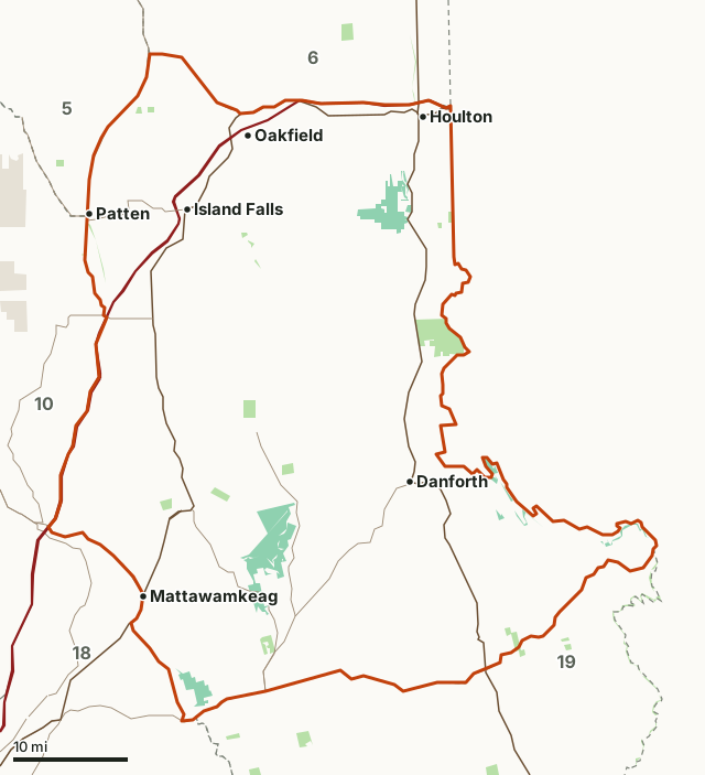
State public lands and parks (BPL)MDIFW land (WMAs)National Park ServiceOther state landWMD 11Neighboring WMDsHighway
| Size | 1,769 square miles (MDIFW) |
|---|---|
| Public land | 2.9% (32,913 acres) |
| Wildlife management areas | Mattawamkeag River WMA, Lt. Gordon Manuel WMA, David Priest (Dwinal Pond) WMA, Booming Ground WMA |
| Deer registered, 2025 | 1,010 |
| Moose registered, 2025 | 42 |
| Bears registered, 2025 | 269 |
| Turkeys registered, 2025 | 112 spring, 61 fall |
| Deer firearms season, 2026 | November 2 to 28 (residents only day October 31) |
| Moose seasons, 2026 | September 28 to October 3 (bulls only); October 12 to 17 (bulls only) |
How many deer, moose and bears are taken in WMD 11?
1,010 deer were registered in WMD 11's towns in 2025, against 706 in 2024. The last 15 years:
| Year | Deer | Moose | Bears | Spring turkeys | Fall turkeys |
|---|---|---|---|---|---|
| 2025 | 1,010 | 42 | 269 | 112 | 61 |
| 2024 | 706 | 49 | 289 | 135 | 77 |
| 2023 | 503 | 45 | 117 | 151 | 9 |
| 2022 | 484 | 54 | 269 | 118 | |
| 2021 | 384 | 38 | 328 | 69 | |
| 2020 | 291 | 44 | 282 | 86 | |
| 2019 | 364 | 43 | 184 | 72 | 35 |
| 2018 | 370 | 45 | 256 | 78 | 78 |
| 2017 | 348 | 41 | 256 | 48 | 35 |
| 2016 | 418 | 59 | 224 | 64 | 44 |
| 2015 | 333 | 45 | 234 | 54 | 27 |
| 2014 | 423 | 45 | 275 | 69 | 27 |
| 2013 | 446 | 44 | 274 | 68 | 3 |
| 2012 | 309 | 78 | 288 | 54 | 0 |
| 2011 | 245 | 108 | 255 | 40 | 0 |
Sources: MDIFW white-tailed deer harvest by town; MDIFW moose harvest by town; MDIFW black bear harvest by town; MDIFW wild turkey harvest by town. Added up by FilledTag from MDIFW's figures by town: each town is counted in the district that holds its centre, so a town on a district line counts wholly on one side. A blank cell means MDIFW lists no figure for the district's towns that year.
Which towns in WMD 11 have the most deer registered?
| Town | Deer, 2025 | Bears, 2025 | Moose, 2025 |
|---|---|---|---|
| Medway | 54 | 9 | 0 |
| Prentiss Twp T7 R3 Nbpp | 48 | 6 | 1 |
| Hodgdon | 44 | 13 | 0 |
| Mattawamkeag | 43 | 3 | 0 |
| Sherman | 41 | 5 | 0 |
| Springfield | 41 | 8 | 0 |
| Crystal | 37 | 1 | 0 |
| Haynesville | 37 | 17 | 4 |
Source: MDIFW's figures by town.
The most moose in 2025: Merrill (6), Haynesville (4), Reed Plt (4), Forkstown Twp (3) and T3 R4 Wels (3).
When are the 2026-27 seasons in WMD 11?
| Season | Dates, 2026-27 |
|---|---|
| Deer, regular archery | October 3 to 30 |
| Deer, youth hunt | October 23 to 24 |
| Deer, Maine residents only day | October 31 |
| Deer, firearms | November 2 to 28 |
| Deer, muzzleloader | November 30 to December 5 |
| Moose, bulls only (by permit) | September 28 to October 3 |
| Moose, bulls only (by permit) | October 12 to 17 |
| Bear, hunting with bait | August 31 to September 26 |
| Bear, hunting with dogs | September 14 to October 30 |
| Bear, general season | August 31 to November 28 |
| Turkey, fall (archery or shotgun) | September 14 to November 7 |
| Turkey, spring (bearded birds) | May 3 to June 5, 2027; 2 birds in this WMD |
Source: MDIFW 2026-27 Maine hunting seasons. Antlerless deer permits, moose permits and bag limits are set by district; MDIFW's law book has them.
How much public land is in WMD 11?
2.9% of WMD 11 is public land: 32,913 of its 1,132,849 acres. The largest share is MDIFW land (WMAs), 21,817 acres.
| Manager | Acres | Share of WMD 11 |
|---|---|---|
| MDIFW land (WMAs) | 21,817 | 1.9% |
| State public lands and parks (BPL) | 11,064 | 1% |
| Other state land | 32 | under 0.1% |
Measured by FilledTag inside MDIFW's district line from USGS Protected Areas Database of the United States (PAD-US 4.1). Much of Maine's woods are private land open to hunting by custom; this table counts only public ownership.
Wildlife management areas in WMD 11
| WMA | Acres in WMD 11 |
|---|---|
| Mattawamkeag River WMA | 11,318 |
| Lt. Gordon Manuel WMA | 6,243 |
| David Priest (Dwinal Pond) WMA | 2,415 |
| Booming Ground WMA | 593 |
Which districts border WMD 11?
| WMD | Public land | Deer, 2025 | Moose, 2025 | Bears, 2025 |
|---|---|---|---|---|
| WMD 5 | 8% | 201 | 271 | 265 |
| WMD 6 | 2.5% | 929 | 163 | 249 |
| WMD 10 | 21.7% | 177 | 28 | 142 |
| WMD 18 | 3.3% | 1,045 | 17 | 173 |
| WMD 19 | 5.3% | 357 | 31 | 180 |
Highways crossing WMD 11: I-95 (110 miles), US 2 (67 miles), US 1 (56 miles), ME 169 (24 miles), ME 170 (20 miles) and ME 171 (18 miles).
Questions hunters ask
How many deer are taken in Maine WMD 11?
Hunters registered 1,010 deer in the towns of WMD 11 in 2025, adding up MDIFW's town figures; the five-year average to 2025 is 617 and the most since 2005 was 1,010 in 2025. The most came from Medway (54), Prentiss Twp T7 R3 Nbpp (48) and Hodgdon (44).
Is there a moose season in WMD 11?
Yes, by permit only. In 2026: bulls only September 28 to October 3; bulls only October 12 to 17 (MDIFW 2026-27 Maine hunting seasons). Hunters registered 42 moose in the district's towns in 2025.
When is deer season in WMD 11 in 2026?
Regular archery October 3 to 30, youth day October 23 to 24, residents only day October 31, firearms November 2 to 28, and muzzleloader November 30 to December 5 (MDIFW 2026-27 Maine hunting seasons). An antlerless deer needs an antlerless permit.
How much public land is in WMD 11?
32,913 acres, 2.9% of the district, by PAD-US 4.1. MDIFW's wildlife management areas here: Mattawamkeag River (11,318 acres), Lt. Gordon Manuel (6,243 acres), David Priest (Dwinal Pond) (2,415 acres) and Booming Ground (593 acres).
Get a Maine hunt plan when they open
Hunt plans for Maine are coming. Join the list and you'll hear first. The first 50 hunters in each new state get their plan free.
Until then, the free FilledTag app for iPhone has a map that works in every state, Maine included.
Where these numbers come from
- Harvest: MDIFW white-tailed deer harvest by town; MDIFW moose harvest by town; MDIFW black bear harvest by town; MDIFW wild turkey harvest by town.
- Seasons: MDIFW 2026-27 Maine hunting seasons.
- District boundary: MDIFW Wildlife Management Districts. WMAs: MDIFW Wildlife Management Area boundaries. Public land: USGS Protected Areas Database of the United States (PAD-US 4.1).
- Highways and towns: U.S. Census Bureau TIGER/Line 2024 primary and secondary roads; U.S. Census Bureau 2024 Gazetteer, places.
FilledTag is not part of the Maine Department of Inland Fisheries and Wildlife. Numbers are copied from MDIFW and federal sources, added up from MDIFW's town figures, or measured from their maps; nothing on this page is estimated by FilledTag.