Chicamuxen Wildlife Management Area: deer harvest, hunting rules and map
Hunters reported 4 deer on Chicamuxen Wildlife Management Area in the 2025-26 season, 3 antlered and 1 antlerless, against 8 in 2024-25. It is a Maryland DNR wildlife management area of about 382 acres in Charles County, in deer management Region B.
Data updated October 2026. Harvest: Maryland DNR Annual Big Game Report 2025-2026, Appendix II. Area: Maryland DNR owned lands (Maryland iMAP); DNR's page for Chicamuxen WMA. Seasons: Maryland DNR Hunting Seasons Calendar for 2026-2027.
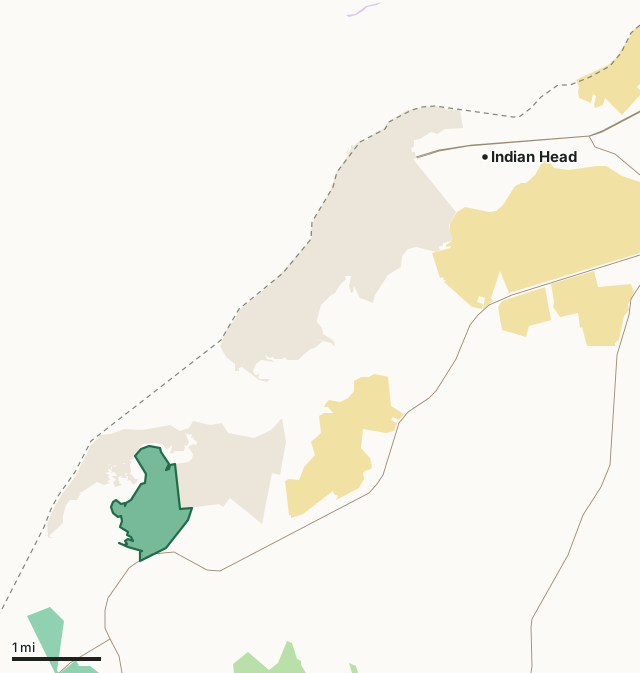
Wildlife management areaState forestState parkNational wildlife refugeMilitary (closed unless the base allows)Chicamuxen WMACounty lineHighway
| Size | 382 acres (measured from DNR's map) |
|---|---|
| County | Charles County |
| Managed by | Wildlife and Heritage Service |
| Deer reported, 2025-26 | 4 (3 antlered, 1 antlerless) |
| Deer reported, 2024-25 | 8 |
| Deer management region | Region B |
| Nearest towns | Indian Head (5 mi), Potomac Heights (6 mi) and Bryans Road (8 mi) |
How many deer are taken on Chicamuxen WMA each year?
| Season | Antlered | Antlerless | All deer |
|---|---|---|---|
| 2025-26 | 3 | 1 | 4 |
| 2024-25 | 4 | 4 | 8 |
Source: the public land table (Appendix II) in DNR's report for each season (Maryland DNR deer and big game report archive).
What is Chicamuxen WMA like?
DNR describes it: "This 382-acre site situated along the Chicamuxen Creek, a Potomac River tributary, in western Charles County consists of prime marshlands as well as uplands, rolling forested habitats, and agricultural fields. The property was the site of a Civil War encampment under the leadership of Union General, Joseph Hooker."
On hunting and other uses: "Hunters enjoy the pursuit of the numerous white-tailed deer found on the property, as well as the abundant puddle ducks which can be hunted at waterfowl blinds along Chicamuxen Creek. Check out a map of the area."
On wildlife: "Chicamuxen marshes abound with a wide variety of waterfowl species including Black Ducks, Gadwall, Mallards, Widgeon, Wood Duck, Bufflehead, Hooded Merganser, Ring-neck, and occasional Scaup and Canvasback. Adult and immature bald eagles can be seen almost daily hunting the marshes and upland areas."
Quoted from DNR's page for Chicamuxen WMA.
What are the rules on Chicamuxen WMA?
- Use of Chicamuxen WMA is generally permitted seven days a week.
- Hunting is allowed in accordance with open seasons, bag limits and shooting hours.
- Trapping and waterfowl hunting is by permit only.
- Be aware of open hunting seasons and visit accordingly.
- A wide variety of forest interior dwelling birds can be observed in the upland forests during the nesting season.
From DNR's page for Chicamuxen WMA.
When can you hunt Chicamuxen WMA in 2026-27?
Seasons follow Region B: archery September 11 to January 31 with breaks, early muzzleloader October 22 to 24, firearm November 28 to December 12 and January 8 to 10, 2027, late muzzleloader December 19 to January 2. Spring turkey runs April 19 to May 24, 2027.
| County | Deer, 2025-26 | Antlered, 2025-26 | Spring turkeys, 2026 | Public land |
|---|---|---|---|---|
| Charles County | 2,096 | 874 | 452 | 7.6% |
Seasons: Maryland DNR Hunting Seasons Calendar for 2026-2027. County harvest: Maryland DNR Annual Big Game Report 2025-2026.
How do you get to Chicamuxen WMA?
Highways within five miles: MD 224, MD 6, MD 425, MD 344 and MD 210. Nearest towns: Indian Head (5 miles), Potomac Heights (6 miles), Bryans Road (8 miles) and Pomfret (10 miles).
Questions hunters ask
How many deer are taken on Chicamuxen WMA?
4 in 2025-26: 3 antlered and 1 antlerless (Maryland DNR Annual Big Game Report 2025-2026, Appendix II). In 2024-25: 8.
Do you need a permit to hunt Chicamuxen WMA?
DNR's page for Chicamuxen WMA says: "Use of Chicamuxen WMA is generally permitted seven days a week. Trapping and waterfowl hunting is by permit only."
What county is Chicamuxen WMA in?
Charles County. Charles County reported 2,096 deer in 2025-26, 874 antlered, and is in Region B.
What can you hunt on Chicamuxen WMA?
DNR: "Hunters enjoy the pursuit of the numerous white-tailed deer found on the property, as well as the abundant puddle ducks which can be hunted at waterfowl blinds along Chicamuxen Creek. Check out a map of the area."
Get a Maryland hunt plan when they open
Hunt plans for Maryland are coming. Join the list and you'll hear first. The first 50 hunters in each new state get their plan free.
Until then, the free FilledTag app for iPhone has a map that works in every state, Maryland included.
Where these facts come from
- Deer by area: the public land tables in Maryland DNR deer and big game report archive. Boundary: Maryland DNR owned lands (Maryland iMAP).
- Seasons: Maryland DNR Hunting Seasons Calendar for 2026-2027; Maryland DNR: 2026-27 archery deer season opens September 11. County harvest: Maryland DNR Annual Big Game Report 2025-2026.
- Public land around it: Maryland DNR owned lands (Maryland iMAP) for state land; USGS Protected Areas Database of the United States (PAD-US 4.1) for federal land. Highways and towns: U.S. Census Bureau TIGER/Line 2024 primary and secondary roads; U.S. Census Bureau 2024 Gazetteer, places.
FilledTag is not part of the Maryland Department of Natural Resources.