Nanjemoy Wildlife Management Area: deer harvest, hunting rules and map
Hunters reported 2 deer on Nanjemoy Wildlife Management Area in the 2025-26 season, 2 antlered and 0 antlerless, against 15 in 2024-25. It is a Maryland DNR wildlife management area of about 1,635 acres in Charles County, in deer management Region B.
Data updated October 2026. Harvest: Maryland DNR Annual Big Game Report 2025-2026, Appendix II. Area: Maryland DNR owned lands (Maryland iMAP); DNR's page for Nanjemoy WMA. Seasons: Maryland DNR Hunting Seasons Calendar for 2026-2027.
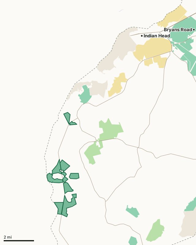
Wildlife management areaState forestState parkNational wildlife refugeMilitary (closed unless the base allows)Nanjemoy WMACounty lineHighway
| Size | 1,635 acres (measured from DNR's map) |
|---|---|
| County | Charles County |
| Managed by | Wildlife and Heritage Service |
| Deer reported, 2025-26 | 2 (2 antlered, 0 antlerless) |
| Deer reported, 2024-25 | 15 |
| Deer management region | Region B |
| Nearest towns | Indian Head (7 mi), Potomac Heights (8 mi) and Bryans Road (10 mi) |
How many deer are taken on Nanjemoy WMA each year?
| Season | Antlered | Antlerless | All deer |
|---|---|---|---|
| 2025-26 | 2 | 0 | 2 |
| 2024-25 | 6 | 9 | 15 |
Source: the public land table (Appendix II) in DNR's report for each season (Maryland DNR deer and big game report archive).
What is Nanjemoy WMA like?
On hunting and other uses: "The Wilson Landing Boat Ramp at the end of Wilson Landing Road off of Route 224 is operated by Charles County Parks (For more info: https://www.charlescountyparks.com/parks/boat-launches ). Hunters come to Nanjemoy WMA for the white-tailed deer, gray squirrels, wild turkey and waterfowl."
On wildlife: "Nanjemoy WMA offers a variety of habitats and miles of marked and unmarked trails. At the end of Wilson Landing Rd. there is an inlet known as Mallows Bay - a unique historical site where you can see the remnants of old ships."
Quoted from DNR's page for Nanjemoy WMA.
What are the rules on Nanjemoy WMA?
- Use of Nanjemoy WMA is generally permitted seven days a week.
- Hunting is allowed in accordance with open seasons, bag limits and shooting hours.
- Use of the handicapped accessible waterfowl blind is by permit and reservation only.
From DNR's page for Nanjemoy WMA.
When can you hunt Nanjemoy WMA in 2026-27?
Seasons follow Region B: archery September 11 to January 31 with breaks, early muzzleloader October 22 to 24, firearm November 28 to December 12 and January 8 to 10, 2027, late muzzleloader December 19 to January 2. Spring turkey runs April 19 to May 24, 2027.
| County | Deer, 2025-26 | Antlered, 2025-26 | Spring turkeys, 2026 | Public land |
|---|---|---|---|---|
| Charles County | 2,096 | 874 | 452 | 7.6% |
Seasons: Maryland DNR Hunting Seasons Calendar for 2026-2027. County harvest: Maryland DNR Annual Big Game Report 2025-2026.
How do you get to Nanjemoy WMA?
Highways within five miles: MD 224, MD 6, MD 425 and MD 344. Nearest towns: Indian Head (7 miles), Potomac Heights (8 miles), Bryans Road (10 miles) and Port Tobacco Village (12 miles).
Questions hunters ask
How many deer are taken on Nanjemoy WMA?
2 in 2025-26: 2 antlered and 0 antlerless (Maryland DNR Annual Big Game Report 2025-2026, Appendix II). In 2024-25: 15.
Do you need a permit to hunt Nanjemoy WMA?
DNR's page for Nanjemoy WMA says: "Use of Nanjemoy WMA is generally permitted seven days a week. Use of the handicapped accessible waterfowl blind is by permit and reservation only."
What county is Nanjemoy WMA in?
Charles County. Charles County reported 2,096 deer in 2025-26, 874 antlered, and is in Region B.
What can you hunt on Nanjemoy WMA?
DNR: "The Wilson Landing Boat Ramp at the end of Wilson Landing Road off of Route 224 is operated by Charles County Parks (For more info: https://www.charlescountyparks.com/parks/boat-launches ). Hunters come to Nanjemoy WMA for the white-tailed deer, gray squirrels, wild turkey and waterfowl."
Get a Maryland hunt plan when they open
Hunt plans for Maryland are coming. Join the list and you'll hear first. The first 50 hunters in each new state get their plan free.
Until then, the free FilledTag app for iPhone has a map that works in every state, Maryland included.
Where these facts come from
- Deer by area: the public land tables in Maryland DNR deer and big game report archive. Boundary: Maryland DNR owned lands (Maryland iMAP).
- Seasons: Maryland DNR Hunting Seasons Calendar for 2026-2027; Maryland DNR: 2026-27 archery deer season opens September 11. County harvest: Maryland DNR Annual Big Game Report 2025-2026.
- Public land around it: Maryland DNR owned lands (Maryland iMAP) for state land; USGS Protected Areas Database of the United States (PAD-US 4.1) for federal land. Highways and towns: U.S. Census Bureau TIGER/Line 2024 primary and secondary roads; U.S. Census Bureau 2024 Gazetteer, places.
FilledTag is not part of the Maryland Department of Natural Resources.