St. Inigoes State Forest: deer harvest, hunting rules and map
Hunters reported 9 deer on St. Inigoes State Forest in the 2025-26 season, 3 antlered and 6 antlerless, against 8 in 2024-25. It is a Maryland DNR state forest of about 932 acres in St. Mary's County, in deer management Region B.
Data updated October 2026. Harvest: Maryland DNR Annual Big Game Report 2025-2026, Appendix II. Area: Maryland DNR owned lands (Maryland iMAP); DNR's page for St. Inigoes SF. Seasons: Maryland DNR Hunting Seasons Calendar for 2026-2027.
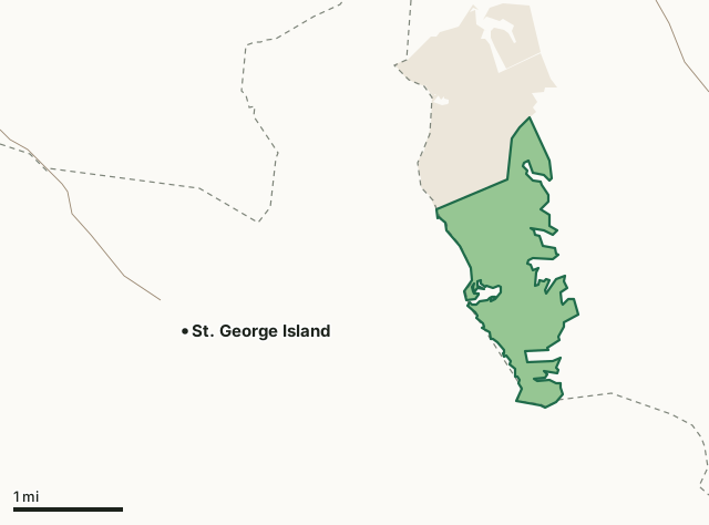
State forestMilitary (closed unless the base allows)St. Inigoes SFCounty lineHighway
| Size | 932 acres (measured from DNR's map) |
|---|---|
| County | St. Mary's County |
| Managed by | Maryland Forest Service |
| Deer reported, 2025-26 | 9 (3 antlered, 6 antlerless) |
| Deer reported, 2024-25 | 8 |
| Deer management region | Region B |
| Nearest towns | St. George Island (3 mi), Piney Point (5 mi) and Tall Timbers (6 mi) |
How many deer are taken on St. Inigoes SF each year?
| Season | Antlered | Antlerless | All deer |
|---|---|---|---|
| 2025-26 | 3 | 6 | 9 |
| 2024-25 | 2 | 6 | 8 |
| 2023-24 | 1 | 8 | 9 |
| 2022-23 | 4 | 4 | 8 |
| 2021-22 | 2 | 3 | 5 |
| 2020-21 | 2 | 9 | 11 |
| 2019-20 | 3 | 4 | 7 |
Source: the public land table (Appendix II) in DNR's report for each season (Maryland DNR deer and big game report archive).
What is St. Inigoes SF like?
DNR describes it: "St. Inigoes State Forest is comprised of 938 acres located on a peninsula between St. Mary’s River and Smith Creek bordering the Potomac River. There are 324 acres of woodland, 524 acres of agricultural land and six residential dwellings on the property."
Quoted from DNR's page for St. Inigoes SF.
When can you hunt St. Inigoes SF in 2026-27?
Seasons follow Region B: archery September 11 to January 31 with breaks, early muzzleloader October 22 to 24, firearm November 28 to December 12 and January 8 to 10, 2027, late muzzleloader December 19 to January 2. Spring turkey runs April 19 to May 24, 2027.
| County | Deer, 2025-26 | Antlered, 2025-26 | Spring turkeys, 2026 | Public land |
|---|---|---|---|---|
| St. Mary's County | 1,933 | 835 | 293 | 3.2% |
Seasons: Maryland DNR Hunting Seasons Calendar for 2026-2027. County harvest: Maryland DNR Annual Big Game Report 2025-2026.
How do you get to St. Inigoes SF?
Highways within five miles: MD 5, MD 235 and MD 249. Nearest towns: St. George Island (3 miles), Piney Point (5 miles), Tall Timbers (6 miles) and Lexington Park (7 miles).
Questions hunters ask
How many deer are taken on St. Inigoes SF?
9 in 2025-26: 3 antlered and 6 antlerless (Maryland DNR Annual Big Game Report 2025-2026, Appendix II). In 2024-25: 8. DNR's tables go back to 2019-20 for this area.
Do you need a permit to hunt St. Inigoes SF?
DNR's public land table counts deer taken here, so it is hunted; check DNR's page for St. Inigoes SF for any permit, drawing or day restrictions before you go.
What county is St. Inigoes SF in?
St. Mary's County. St. Mary's County reported 1,933 deer in 2025-26, 835 antlered, and is in Region B.
Get a Maryland hunt plan when they open
Hunt plans for Maryland are coming. Join the list and you'll hear first. The first 50 hunters in each new state get their plan free.
Until then, the free FilledTag app for iPhone has a map that works in every state, Maryland included.
Where these facts come from
- Deer by area: the public land tables in Maryland DNR deer and big game report archive. Boundary: Maryland DNR owned lands (Maryland iMAP).
- Seasons: Maryland DNR Hunting Seasons Calendar for 2026-2027; Maryland DNR: 2026-27 archery deer season opens September 11. County harvest: Maryland DNR Annual Big Game Report 2025-2026.
- Public land around it: Maryland DNR owned lands (Maryland iMAP) for state land; USGS Protected Areas Database of the United States (PAD-US 4.1) for federal land. Highways and towns: U.S. Census Bureau TIGER/Line 2024 primary and secondary roads; U.S. Census Bureau 2024 Gazetteer, places.
FilledTag is not part of the Maryland Department of Natural Resources.