Warrior Mountain Wildlife Management Area: deer harvest, hunting rules and map
Hunters reported 127 deer on Warrior Mountain Wildlife Management Area in the 2025-26 season, 66 antlered and 61 antlerless, against 110 in 2024-25. It is a Maryland DNR wildlife management area of about 5,144 acres in Allegany County, in deer management Region A.
Data updated October 2026. Harvest: Maryland DNR Annual Big Game Report 2025-2026, Appendix II. Area: Maryland DNR owned lands (Maryland iMAP); DNR's page for Warrior Mountain WMA. Seasons: Maryland DNR Hunting Seasons Calendar for 2026-2027.
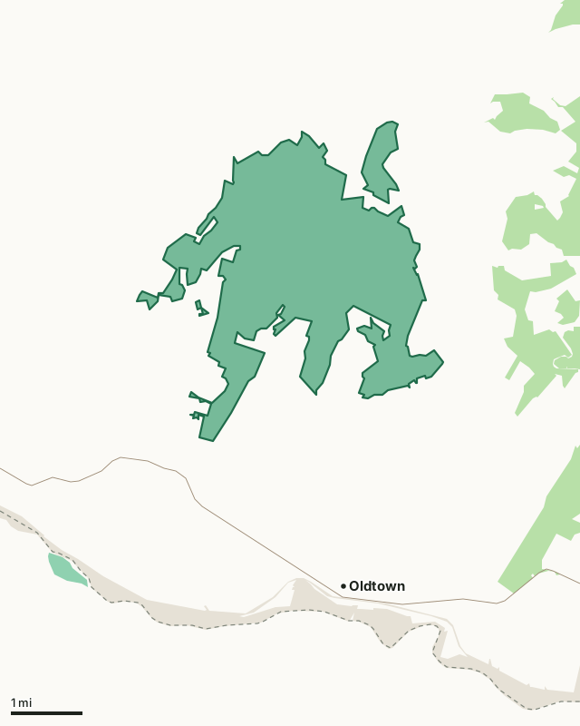
Wildlife management areaState forestNational Park ServiceWarrior Mountain WMACounty lineHighway
| Size | 5,144 acres (measured from DNR's map) |
|---|---|
| County | Allegany County |
| Managed by | Wildlife and Heritage Service |
| Deer reported, 2025-26 | 127 (66 antlered, 61 antlerless) |
| Deer reported, 2024-25 | 110 |
| Deer management region | Region A |
| Nearest towns | Oldtown (3 mi), Spring Gap (3 mi) and Pleasant Grove (4 mi) |
How many deer are taken on Warrior Mountain WMA each year?
| Season | Antlered | Antlerless | All deer |
|---|---|---|---|
| 2025-26 | 66 | 61 | 127 |
| 2024-25 | 51 | 59 | 110 |
Source: the public land table (Appendix II) in DNR's report for each season (Maryland DNR deer and big game report archive).
What is Warrior Mountain WMA like?
DNR describes it: "Remotely located in central Allegany County, Warrior Mountain WMA's 5,204 acres of forest blanket the ridge and stream valley topography which is typically found in Western Maryland. At the peak of Warrior Mountain, a power line clearing overlooks a spectacular view of the surrounding terrain."
On hunting and other uses: "Hunters will enjoy an excellent day afield pursuing wild turkeys, white-tailed deer and gray squirrels. A primitive campground on this WMA provides overnight accommodations for hardy hunters during the fall and winter."
On wildlife: "Wild turkeys were here long before the earliest American settlers. In the spring, gobblers fill the air with their familiar calls, as they advertise for a mate."
Quoted from DNR's page for Warrior Mountain WMA.
What are the rules on Warrior Mountain WMA?
- Use of the Warrior Mountain WMA is generally permitted seven days a week throughout the year.
- Hunting is allowed in accordance with open seasons and shooting hours.
- No special permits or drawings are required to hunt this area, except appropriate licenses and stamps.
- The property provides excellent opportunity to pursue species such as white-tailed deer, wild turkeys, gray squirrels, cottontail rabbits, and ruffed grouse.
- There is a primitive camping area available on the area, accessed via Ruby Road. The area is available for all hunting seasons on a first come, first served basis. There are no electric hook-ups available.
From DNR's page for Warrior Mountain WMA.
When can you hunt Warrior Mountain WMA in 2026-27?
Seasons follow Region A: archery September 11 to January 31 with breaks, early muzzleloader October 22 to 24, firearm November 28 to December 12, late muzzleloader December 19 to January 2. Bear season in the western counties is October 26 to 31. Spring turkey runs April 19 to May 24, 2027.
| County | Deer, 2025-26 | Antlered, 2025-26 | Spring turkeys, 2026 | Public land |
|---|---|---|---|---|
| Allegany County | 2,924 | 1,739 | 372 | 27.7% |
Seasons: Maryland DNR Hunting Seasons Calendar for 2026-2027. County harvest: Maryland DNR Annual Big Game Report 2025-2026.
How do you get to Warrior Mountain WMA?
Highways within five miles: US 40, I-68, MD 51 and MD 144. Nearest towns: Oldtown (3 miles), Spring Gap (3 miles), Pleasant Grove (4 miles) and Flintstone (5 miles).
Questions hunters ask
How many deer are taken on Warrior Mountain WMA?
127 in 2025-26: 66 antlered and 61 antlerless (Maryland DNR Annual Big Game Report 2025-2026, Appendix II). In 2024-25: 110.
Do you need a permit to hunt Warrior Mountain WMA?
DNR's page for Warrior Mountain WMA says: "Use of the Warrior Mountain WMA is generally permitted seven days a week throughout the year. No special permits or drawings are required to hunt this area, except appropriate licenses and stamps."
What county is Warrior Mountain WMA in?
Allegany County. Allegany County reported 2,924 deer in 2025-26, 1,739 antlered, and is in Region A.
What can you hunt on Warrior Mountain WMA?
DNR: "Hunters will enjoy an excellent day afield pursuing wild turkeys, white-tailed deer and gray squirrels. A primitive campground on this WMA provides overnight accommodations for hardy hunters during the fall and winter."
Get a Maryland hunt plan when they open
Hunt plans for Maryland are coming. Join the list and you'll hear first. The first 50 hunters in each new state get their plan free.
Until then, the free FilledTag app for iPhone has a map that works in every state, Maryland included.
Where these facts come from
- Deer by area: the public land tables in Maryland DNR deer and big game report archive. Boundary: Maryland DNR owned lands (Maryland iMAP).
- Seasons: Maryland DNR Hunting Seasons Calendar for 2026-2027; Maryland DNR: 2026-27 archery deer season opens September 11. County harvest: Maryland DNR Annual Big Game Report 2025-2026.
- Public land around it: Maryland DNR owned lands (Maryland iMAP) for state land; USGS Protected Areas Database of the United States (PAD-US 4.1) for federal land. Highways and towns: U.S. Census Bureau TIGER/Line 2024 primary and secondary roads; U.S. Census Bureau 2024 Gazetteer, places.
FilledTag is not part of the Maryland Department of Natural Resources.