Wellington Wildlife Management Area: deer harvest, hunting rules and map
Hunters reported 6 deer on Wellington Wildlife Management Area in the 2025-26 season, 3 antlered and 3 antlerless, against 16 in 2024-25. It is a Maryland DNR wildlife management area of about 664 acres in Somerset County, in deer management Region B.
Data updated October 2026. Harvest: Maryland DNR Annual Big Game Report 2025-2026, Appendix II. Area: Maryland DNR owned lands (Maryland iMAP); DNR's page for Wellington WMA. Seasons: Maryland DNR Hunting Seasons Calendar for 2026-2027.
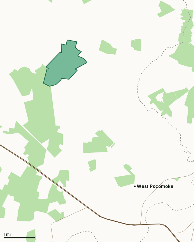
Wildlife management areaState forestWellington WMACounty lineHighway
| Size | 664 acres (measured from DNR's map) |
|---|---|
| County | Somerset County |
| Managed by | Wildlife and Heritage Service |
| Deer reported, 2025-26 | 6 (3 antlered, 3 antlerless) |
| Deer reported, 2024-25 | 16 |
| Deer management region | Region B |
| Nearest towns | West Pocomoke (4 mi), Princess Anne (5 mi) and Pocomoke City (7 mi) |
How many deer are taken on Wellington WMA each year?
| Season | Antlered | Antlerless | All deer |
|---|---|---|---|
| 2025-26 | 3 | 3 | 6 |
| 2024-25 | 7 | 9 | 16 |
| 2023-24 | 0 | 6 | 6 |
| 2022-23 | 4 | 9 | 13 |
| 2021-22 | 4 | 13 | 17 |
| 2020-21 | 4 | 6 | 10 |
| 2019-20 | 4 | 4 | 8 |
Source: the public land table (Appendix II) in DNR's report for each season (Maryland DNR deer and big game report archive).
What is Wellington WMA like?
DNR describes it: "Predominantly forest, the 400 acre Wellington WMA is located in eastern Somerset County. Wellington WMA is part of one of the largest forested tracts found on Maryland's Eastern Shore."
On hunting and other uses: "Hunters will find excellent opportunities to bag white-tailed deer, turkeys, gray squirrels, woodcock, bobwhite quail and cottontail rabbits. Unmarked trails invite those who enjoy a challenging hike or an all-terrain bicycle ride."
On wildlife: "The extensive forests at Wellington attract forest wildlife including woodcock, hairy and downy woodpeckers, and many species of warblers. Wellington's forests provide critical nesting areas for songbirds which migrate from Central and South America."
Quoted from DNR's page for Wellington WMA.
What are the rules on Wellington WMA?
- Use of Wellington WMA is generally permitted seven days a week throughout the year.
- Hunting is allowed in accordance with open seasons and shooting hours, unless otherwise noted.
- All State and Federal Hunting Laws and Regulations are applicable.
- Dove hunting is restricted to certain days and shooting hours.
From DNR's page for Wellington WMA.
When can you hunt Wellington WMA in 2026-27?
Seasons follow Region B: archery September 11 to January 31 with breaks, early muzzleloader October 22 to 24, firearm November 28 to December 12 and January 8 to 10, 2027, late muzzleloader December 19 to January 2. Spring turkey runs April 19 to May 24, 2027.
| County | Deer, 2025-26 | Antlered, 2025-26 | Spring turkeys, 2026 | Public land |
|---|---|---|---|---|
| Somerset County | 1,846 | 657 | 184 | 22.2% |
Seasons: Maryland DNR Hunting Seasons Calendar for 2026-2027. County harvest: Maryland DNR Annual Big Game Report 2025-2026.
How do you get to Wellington WMA?
Highways within five miles: US 13, MD 364, MD 388, MD 667, MD 413 and MD 675. Nearest towns: West Pocomoke (4 miles), Princess Anne (5 miles), Pocomoke City (7 miles) and Eden (8 miles).
Questions hunters ask
How many deer are taken on Wellington WMA?
6 in 2025-26: 3 antlered and 3 antlerless (Maryland DNR Annual Big Game Report 2025-2026, Appendix II). In 2024-25: 16. DNR's tables go back to 2019-20 for this area.
Do you need a permit to hunt Wellington WMA?
DNR's page for Wellington WMA says: "Use of Wellington WMA is generally permitted seven days a week throughout the year. Use of Wellington WMA is generally permitted seven days a week throughout the year."
What county is Wellington WMA in?
Somerset County. Somerset County reported 1,846 deer in 2025-26, 657 antlered, and is in Region B.
What can you hunt on Wellington WMA?
DNR: "Hunters will find excellent opportunities to bag white-tailed deer, turkeys, gray squirrels, woodcock, bobwhite quail and cottontail rabbits. Unmarked trails invite those who enjoy a challenging hike or an all-terrain bicycle ride."
Get a Maryland hunt plan when they open
Hunt plans for Maryland are coming. Join the list and you'll hear first. The first 50 hunters in each new state get their plan free.
Until then, the free FilledTag app for iPhone has a map that works in every state, Maryland included.
Where these facts come from
- Deer by area: the public land tables in Maryland DNR deer and big game report archive. Boundary: Maryland DNR owned lands (Maryland iMAP).
- Seasons: Maryland DNR Hunting Seasons Calendar for 2026-2027; Maryland DNR: 2026-27 archery deer season opens September 11. County harvest: Maryland DNR Annual Big Game Report 2025-2026.
- Public land around it: Maryland DNR owned lands (Maryland iMAP) for state land; USGS Protected Areas Database of the United States (PAD-US 4.1) for federal land. Highways and towns: U.S. Census Bureau TIGER/Line 2024 primary and secondary roads; U.S. Census Bureau 2024 Gazetteer, places.
FilledTag is not part of the Maryland Department of Natural Resources.