Deer Permit Area 282: deer harvest, seasons and public land
Minnesota's Deer Permit Area 282 covers 1,130 square miles of Renville, Chippewa and Kandiyohi counties, around Olivia. Hunters registered 242 deer here in 2025, 209 of them adult bucks, by the DNR's 2025 Deer Harvest Report. That is up 12% from 2024, and the most in the 5 years shown. 0.9% of DPA 282 is public land open to the public, the largest share state wildlife management areas (3,474 acres), by USGS PAD-US 4.1 (fee land open to the public).
Data updated October 2026. Harvest: DNR Deer Harvest Reports, 2021 to 2025. Seasons: the DNR's 2026 deer permit area map. Land: PAD-US 4.1, DNR WMA and Walk-In Access layers.
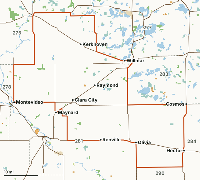
State wildlife management areasState forest and other DNR landNational wildlife refuges and waterfowl production areasState parksCounty, city and regional landWalk-In AccessDPA 282Neighboring deer permit areasLakeHighway
| Counties | Renville County, Chippewa County, Kandiyohi County, Swift County and Meeker County |
|---|---|
| Size | 722,923 acres (1,130 square miles) |
| 2026 bag limit | One-deer limit: antlerless permit lottery (25) |
| Firearm A season, 2026 | Nov. 7 to Nov. 15, 2026 |
| Deer registered, 2025 | 242 (209 adult bucks) |
| Firearms hunters, 2025 | 752 |
| Public land | 0.9% (6,338 acres) |
| WMAs | 16 (3,467 acres inside DPA 282) |
| Walk-In Access | 2 sites, 166 acres |
| Towns in and near it | Olivia, Clara City, Bird Island, Willmar, Cosmos and Maynard |
How many deer are harvested in DPA 282?
The DNR registered 242 deer in DPA 282 in 2025: 209 adult bucks, 28 adult does and 5 fawns, about 0.2 deer for each of the 1,127 square miles of land the DNR counts in it. 752 hunters used their firearms license here in the A season and registered 181 deer, about 24 deer for every 100 of them. Archers: 205 hunters, 32 deer.
| Year | Deer registered | Adult bucks | Adult does | Fawns | Deer per square mile | Firearms hunters | Firearms harvest | Archery hunters | Archery harvest | Muzzleloader hunters | Muzzleloader harvest |
|---|---|---|---|---|---|---|---|---|---|---|---|
| 2025 | 242 | 209 | 28 | 5 | 0.21 | 752 | 181 | 205 | 32 | 92 | 21 |
| 2024 | 217 | 187 | 27 | 3 | 0.19 | 822 | 165 | 215 | 29 | 99 | 9 |
| 2023 | 209 | 165 | 36 | 8 | 0.19 | 742 | 139 | 211 | 39 | 131 | 23 |
| 2022 | 210 | 172 | 30 | 8 | 0.19 | 795 | 156 | 199 | 29 | 101 | 16 |
| 2021 | 206 | 180 | 17 | 9 | 0.18 | 801 | 160 | 202 | 22 | 104 | 11 |
Source: Minnesota DNR Deer Harvest Reports, 2025, 2024, 2023, 2022 and 2021: Table 3 (all deer, special hunts left out), Tables 4 to 6 (archery, firearms A season, muzzleloader). Deer per square mile is the DNR's total divided by the DNR's land area for the permit area. A blank means the DNR printed no row for DPA 282 that year.
When are the 2026 deer seasons in DPA 282?
DPA 282 is a "One-deer limit: antlerless permit lottery (25)" area for 2026. It is in the 200 series, which sets its firearms dates. Firearm A season: Nov. 7 to Nov. 15, 2026.
| Season | 2026 dates or rule |
|---|---|
| Bag limit designation | One-deer limit: antlerless permit lottery (25) |
| Archery | Sept. 19 to Dec. 31, 2026 |
| Firearm A season | Nov. 7 to Nov. 15, 2026 |
| Muzzleloader | Nov. 28 to Dec. 13, 2026 |
| Youth season | Oct. 15 to Oct. 18, 2026 |
| Disease management | CWD surveillance zone |
| CWD testing | Mandatory CWD testing Nov. 7-8; Voluntary CWD testing remainder of all seasons |
Source: Minnesota DNR deer permit areas, 2026 seasons (July 2026 - June 2027). Special CWD related regulations in this area. See mndnr.gov/cwd for details. Check the DNR's regulations before you go: dates and limits can change during the year.
How much public land is in DPA 282?
6,338 of DPA 282's 722,923 acres are public land open to the public (0.9%). The biggest share is state wildlife management areas: 3,474 acres.
| Manager | Acres | Share of DPA 282 |
|---|---|---|
| State wildlife management areas | 3,474 | 0.5% |
| National wildlife refuges and waterfowl production areas | 2,662 | 0.4% |
| County, city and regional land | 196 | under 0.1% |
| State forest and other DNR land | 3 | under 0.1% |
| Land trusts and other open land | 3 | under 0.1% |
| All public land open to the public | 6,338 | 0.9% |
Measured by FilledTag inside the DNR's boundary from USGS PAD-US 4.1 (fee land open to the public). Hunting rules differ by manager: state wildlife management areas, state forest land and national forests are open to hunting in season; refuges and waterfowl production areas follow U.S. Fish and Wildlife Service rules; state parks allow hunting only in special hunts; national park land is closed to hunting; city and county parks set their own rules. PAD-US 4.1 leaves out most of the tax-forfeited land Minnesota counties manage, much of it open to hunting, so the public land here may be more than shown; the county land department has the maps.
Wildlife Management Areas in DPA 282
DNR WMAs in DPA 282, largest first, with the acres of each inside it:
- Grace Marshes WMA: 922 acres
- Whitefield WMA: 488 acres
- Chetomba Creek WMA: 322 acres
- Byholt Marsh WMA: 243 acres
- Numo WMA: 207 acres
- Cuka WMA: 199 acres
- Sena WMA: 184 acres
- Dalton Johnson WMA: 171 acres
- Hollerberg Lake WMA: 160 acres
- Reed WMA: 118 acres
- Winfield WMA: 108 acres
- Boike WMA: 104 acres
- Rosaasen Slough WMA: 93 acres
- Franko WMA: 67 acres
- Hayes-myhre WMA: 41 acres
- Shakopee WMA: 40 acres
Other large public areas here, by PAD-US: Kandiyohi County Waterfowl Production Area (1,833 acres), Swift County Waterfowl Production Area (507 acres) and Renville County Waterfowl Production Area (322 acres).
Walk-In Access in DPA 282
The DNR's 2026 Walk-In Access layer shows 2 sites in DPA 282, 166 acres of private land open to hunters with a Walk-In Access validation from September 1 to May 31. The largest is Chippewa WIA #823 (119 acres). DNR Walk-In Access.
How do you get to DPA 282?
Highways through it: MN 7 (about 33 miles inside), US 12 (about 32 miles inside), US 71 (about 31 miles inside), MN 23 (about 31 miles inside) and US 212 (about 20 miles inside). Towns inside: Olivia, Clara City, Bird Island, Renville, Pennock and Prinsburg. Nearby: Willmar (on the line), Cosmos (on the line), Maynard (on the line) and Montevideo (on the line).
Which deer permit areas border DPA 282?
DPA 282 touches 7 other deer permit areas. Their latest DNR harvest and public land, for comparison:
| DPA | Deer harvested | Year | Public land | Walk-In Access sites |
|---|---|---|---|---|
| DPA 275 | 997 | 2025 | 3.7% | 6 |
| DPA 277 | 4,575 | 2025 | 5.7% | 7 |
| DPA 278 | 639 | 2025 | 18.8% | 2 |
| DPA 281 | 1,343 | 2025 | 2.1% | 5 |
| DPA 283 | 584 | 2025 | 3.7% | 5 |
| DPA 284 | 714 | 2025 | 1.5% | 4 |
| DPA 290 | 1,202 | 2025 | 0.9% | 5 |
Questions hunters ask
How many deer were harvested in DPA 282 in 2025?
242 deer were registered: 209 adult bucks, 28 adult does and 5 fawns (DNR 2025 Deer Harvest Report, Table 3). The most in the 5 years shown was 242, in 2025.
What is the 2026 bag limit in DPA 282?
The DNR lists DPA 282 as "One-deer limit: antlerless permit lottery (25)" for 2026. Firearm A season: Nov. 7 to Nov. 15, 2026.
Is there public land to hunt in DPA 282?
Yes. 6,338 acres, 0.9% of the permit area, are public land open to the public by PAD-US 4.1, mostly state wildlife management areas. The DNR's map shows 16 wildlife management areas here, the largest Grace Marshes WMA (922 acres). Walk-In Access adds 2 sites (166 acres).
How many firearms hunters hunt DPA 282?
752 in the 2025 firearms A season, by the DNR's Table 5. They registered 181 deer, 162 of them adult bucks.
Get a Minnesota hunt plan when they open
Hunt plans for Minnesota are coming. Join the list and you'll hear first. The first 50 hunters in each new state get their plan free.
Until then, the free FilledTag app for iPhone has a map that works in every state, Minnesota included.
Where these numbers come from
- Deer harvest: Minnesota DNR Deer Harvest Reports (2021 to 2025, 2025 report).
- Seasons: Minnesota DNR deer permit areas, 2026 seasons; DNR season calendar.
- Public land: USGS PAD-US 4.1 (fee land open to the public). Wildlife Management Areas: Minnesota DNR Wildlife Management Area boundaries, publicly accessible. Walk-In Access: Minnesota DNR Walk-In Access sites.
- Boundaries: Minnesota DNR deer permit areas, 2026 seasons. Highways and towns: U.S. Census Bureau TIGER/Line 2024 primary and secondary roads; U.S. Census Bureau 2024 Gazetteer, places.
FilledTag is not part of the Minnesota Department of Natural Resources. Numbers are copied from the DNR and the federal sources above, or measured from their maps; nothing on this page is estimated by FilledTag.
Minnesota hunting Renville County Chippewa County Kandiyohi County Swift County Meeker County DPA 275 DPA 277 DPA 278 DPA 281 DPA 283 DPA 284 DPA 290