Beaver Creek Wildlife Management Area: hunting and access
Beaver Creek Wildlife Management Area is 1,294 acres of state land managed by the Minnesota DNR in Fillmore and Murray counties, near Slayton, inside Deer Permit Areas 655 and 295. The DNR's WMA data lists deer, wild turkey, pheasants, ducks and geese, ruffed grouse and other forest upland birds, mourning doves and small game for it. Hunters registered 451 deer in DPA 655 in 2025.
Data updated October 2026. Area facts: the DNR's wildlife management area data, read 2026-10. Harvest: DNR Deer Harvest Reports, 2021 to 2025.
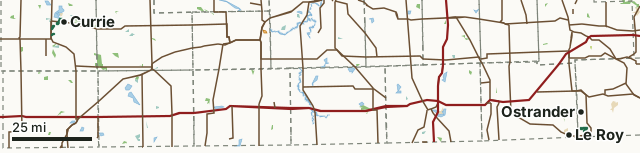
State wildlife management areasState forest and other DNR landNational wildlife refuges and waterfowl production areasState parksWalk-In AccessBeaver Creek WMACounty lineLakeHighway
| Size | 1,294 acres in 6 pieces |
|---|---|
| Counties | Fillmore County and Murray County |
| Deer Permit Area | DPA 655, DPA 295 |
| DNR lists for hunting | deer, wild turkey, pheasants, ducks and geese, ruffed grouse and other forest upland birds, mourning doves and small game |
| Nearest town (DNR) | Slayton |
| DNR area office | Slayton-Talcot Lake |
| Special restrictions | Yes, see the rules below |
| Nearest towns | Currie (next to it), The Lakes (2 mi) and Slayton (2 mi) |
What is Beaver Creek WMA like?
This subunit is oak forest along Beaver Creek. Woodlots are present and comprised of oak, ash, aspen, black cherry and elm. Upland fields consists of native warm season and cool season grasses. Several natural wetlands exist with Beaver Creek running through the unit. Three parcels of wooded valley habitat scattered along Beaver Creek between Slayton and Currie. This is one of the few wooded areas in Murray County. The area is a riparian forest along Beaver Creek and the south shore of Lake Shetek with some food plots.
Management emphasis is to maintain a rich, diverse interspersion of several communities. Timber management, prescribed burning, food plots, and nesting cover development and maintenance practices are utilized. Five parking lots exist on unit. Water levels on this unit are managed for waterfowl production and hunting. This area is managed for a large deer herd that winters here every year. Recreation is dominated by hunting, trapping and general wildlife observations. A good place to hunt raccoons and squirrels. A grant-in-aid snowmobile trail corridor passes through the unit and can be used off-season for walking.
In the DNR's words, from its wildlife management area data.
What can you hunt on Beaver Creek WMA?
The DNR's WMA data lists deer, wild turkey, pheasants, ducks and geese, ruffed grouse and other forest upland birds, mourning doves and small game for Beaver Creek WMA. Each follows the statewide season and, for deer, the bag limit of the permit area.
What are the rules on Beaver Creek WMA?
Open to hunting and trapping in the regular seasons under the DNR's statewide WMA rules.
Special restriction the DNR lists for Beaver Creek WMA: A special use permit is required for beaver trapping when allowed.
How many deer are taken around Beaver Creek WMA?
Beaver Creek WMA lies in 2 deer permit areas. The DNR registered 451 deer in DPA 655 in 2025, against 459 in 2024.
| DPA | Beaver Creek WMA acres in it | Deer, 2025 | Deer, 2024 | Deer, 2023 |
|---|---|---|---|---|
| DPA 655 | 781 | 451 | 459 | 431 |
| DPA 295 | 512 | 904 | 835 | 827 |
Harvest for the whole deer permit area, not the WMA alone: Minnesota DNR Deer Harvest Reports (2021 to 2025, 2025 report).
How do you get to Beaver Creek WMA?
From Slayton, go 2 miles north on hwy 59 and 1/2 mile east on township road. From Ostrander, go 1 mile E on CSAH 3 then 5.5 miles S on township rd. From Slayton, 1/2 mile north on Hwy 59, 1 mile east on township road. From Currie, go 2 miles west on Hwy 30.
There is a grass parking lot in the northeast corner of the unit. Plenty off access points off Township roads with numerous parking lots available. There are three parking lots throughout this unit.
Nearest towns: Currie (next to it), The Lakes (2 miles), Slayton (2 miles) and Le Roy (4 miles). Highways within 5 miles: MN 30, US 59, MN 56, US 63 and MN 267. 1 Walk-In Access site within 3 miles.
What other public land is near Beaver Creek WMA?
DNR WMAs within 10 miles:
- Elder WMA: 20 acres, 1.2 miles away
- Rupp WMA: 83 acres, 1.2 miles away
- Upper Iowa River WMA: 131 acres, 1.4 miles away
- Nosek WMA: 141 acres, 2 miles away
- Engebretson WMA: 55 acres, 2.3 miles away
- H.C. Southwick WMA: 569 acres, 2.8 miles away
Public land within 3 miles of Beaver Creek WMA
Counting Beaver Creek WMA itself, 3,291 of the 78,196 acres within 3 miles of its boundary are public land open to the public (4.2%), by USGS PAD-US 4.1 (fee land open to the public).
| Manager | Acres within 3 miles |
|---|---|
| State wildlife management areas | 1,794 |
| State parks | 820 |
| National wildlife refuges and waterfowl production areas | 677 |
Questions hunters ask
Where is Beaver Creek WMA?
In Fillmore and Murray counties, near Slayton. The DNR's directions: From Slayton, go 2 miles north on hwy 59 and 1/2 mile east on township road. From Ostrander, go 1 mile E on CSAH 3 then 5.5 miles S on township rd. From Slayton, 1/2 mile north on Hwy 59, 1 mile east on township road. From Currie, go 2 miles west on Hwy 30.
Which deer permit area is Beaver Creek WMA in?
DPA 655 (781 acres) and DPA 295 (512 acres). Each part follows its own permit area's bag limit.
How much public land is around Beaver Creek WMA?
3,291 acres within 3 miles of its boundary, Beaver Creek WMA included, by PAD-US 4.1. 6 other WMAs are within 10 miles, the closest Elder WMA (1.2 miles).
Get a Minnesota hunt plan when they open
Hunt plans for Minnesota are coming. Join the list and you'll hear first. The first 50 hunters in each new state get their plan free.
Until then, the free FilledTag app for iPhone has a map that works in every state, Minnesota included.
Where these facts come from
- Area description, species, rules and directions: DNR, Beaver Creek WMA; Minnesota DNR Wildlife Management Area boundaries, publicly accessible.
- Boundary and acres: the DNR's map layer above. Surrounding public land: USGS PAD-US 4.1 (fee land open to the public).
- Deer harvest: Minnesota DNR Deer Harvest Reports (2021 to 2025, 2025 report).
FilledTag is not part of the Minnesota Department of Natural Resources. Check the DNR's rules and posted signs before you go.
Minnesota hunting Fillmore County Murray County DPA 655 DPA 295