Clay County Wildlife Management Area: hunting and access
Clay County Wildlife Management Area is 924 acres of state land managed by the Minnesota DNR in Clay County, near Hawley, inside Deer Permit Area 269. The DNR's WMA data lists deer, pheasants, ducks and geese, mourning doves and small game for it. Hunters registered 464 deer in DPA 269 in 2025.
Data updated October 2026. Area facts: the DNR's wildlife management area data, read 2026-10. Harvest: DNR Deer Harvest Reports, 2021 to 2025.
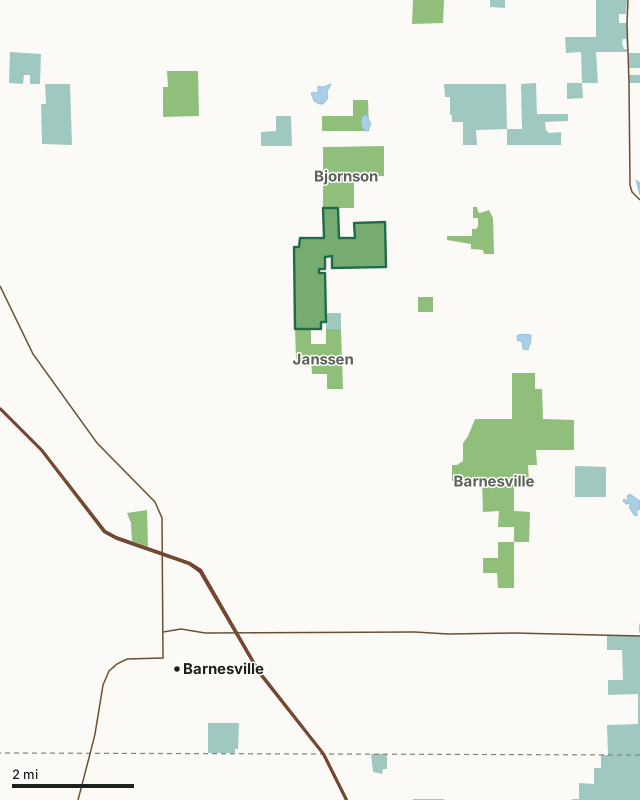
State wildlife management areasNational wildlife refuges and waterfowl production areasClay County WMACounty lineLakeHighway
| Size | 924 acres |
|---|---|
| County | Clay County |
| Deer Permit Area | DPA 269 |
| DNR lists for hunting | deer, pheasants, ducks and geese, mourning doves and small game |
| Nearest town (DNR) | Hawley |
| DNR area office | Detroit Lakes |
| Nearest towns | Barnesville (6 mi), Hawley (8 mi) and Baker (9 mi) |
What can you hunt on Clay County WMA?
The DNR's WMA data lists deer, pheasants, ducks and geese, mourning doves and small game for Clay County WMA. Each follows the statewide season and, for deer, the bag limit of the permit area.
What are the rules on Clay County WMA?
Open to hunting and trapping in the regular seasons under the DNR's statewide WMA rules.
How many deer are taken around Clay County WMA?
Clay County WMA lies in Deer Permit Area 269. The DNR registered 464 deer in DPA 269 in 2025, against 418 in 2024.
| DPA | Clay County WMA acres in it | Deer, 2025 | Deer, 2024 | Deer, 2023 |
|---|---|---|---|---|
| DPA 269 | 924 | 464 | 418 | 395 |
Harvest for the whole deer permit area, not the WMA alone: Minnesota DNR Deer Harvest Reports (2021 to 2025, 2025 report).
How do you get to Clay County WMA?
From Hawley, go 9 miles S on CSAH 31 then 1 mile W on TWP RD.
Clay WMA consists of two distinct units with various access points from Hwy 10 on the north side, 210th St. S. which goes between both units, 100th Ave S. which borders the west unit on the north and the east unit on the south, and 220th St. S. on the east side.
Nearest towns: Barnesville (6 miles), Hawley (8 miles), Baker (9 miles) and Glyndon (13 miles). Highways within 5 miles: US 52, I-94, MN 9, MN 32 and MN 34.
What other public land is near Clay County WMA?
DNR WMAs within 10 miles:
- Janssen WMA: 319 acres, next to it
- Bjornson WMA: 647 acres, next to it
- Hay Creek WMA: 40 acres, 0.7 miles away
- Skree WMA: 165 acres, 1 mile away
- Magnusson WMA: 267 acres, 2.5 miles away
- Barnesville WMA: 1,629 acres, 2.7 miles away
Public land within 3 miles of Clay County WMA
Counting Clay County WMA itself, 3,113 of the 30,628 acres within 3 miles of its boundary are public land open to the public (10.2%), by USGS PAD-US 4.1 (fee land open to the public).
| Manager | Acres within 3 miles |
|---|---|
| State wildlife management areas | 2,322 |
| National wildlife refuges and waterfowl production areas | 791 |
Questions hunters ask
Where is Clay County WMA?
In Clay County, near Hawley. The DNR's directions: From Hawley, go 9 miles S on CSAH 31 then 1 mile W on TWP RD.
Which deer permit area is Clay County WMA in?
Deer Permit Area 269. Its bag limit and firearms dates apply.
How much public land is around Clay County WMA?
3,113 acres within 3 miles of its boundary, Clay County WMA included, by PAD-US 4.1. 6 other WMAs are within 10 miles, the closest Janssen WMA (next to it).
Get a Minnesota hunt plan when they open
Hunt plans for Minnesota are coming. Join the list and you'll hear first. The first 50 hunters in each new state get their plan free.
Until then, the free FilledTag app for iPhone has a map that works in every state, Minnesota included.
Where these facts come from
- Area description, species, rules and directions: DNR, Clay County WMA; Minnesota DNR Wildlife Management Area boundaries, publicly accessible.
- Boundary and acres: the DNR's map layer above. Surrounding public land: USGS PAD-US 4.1 (fee land open to the public).
- Deer harvest: Minnesota DNR Deer Harvest Reports (2021 to 2025, 2025 report).
FilledTag is not part of the Minnesota Department of Natural Resources. Check the DNR's rules and posted signs before you go.