Crow Wing Chain Wildlife Management Area: hunting and access
Crow Wing Chain Wildlife Management Area is 3,334 acres of state land managed by the Minnesota DNR in Hubbard and Wadena counties, near Hubbard, inside Deer Permit Areas 246 and 259. The DNR's WMA data lists deer, ducks and geese, ruffed grouse and other forest upland birds, bear and small game for it. Hunters registered 3,143 deer in DPA 246 in 2025.
Data updated October 2026. Area facts: the DNR's wildlife management area data, read 2026-10. Harvest: DNR Deer Harvest Reports, 2021 to 2025.
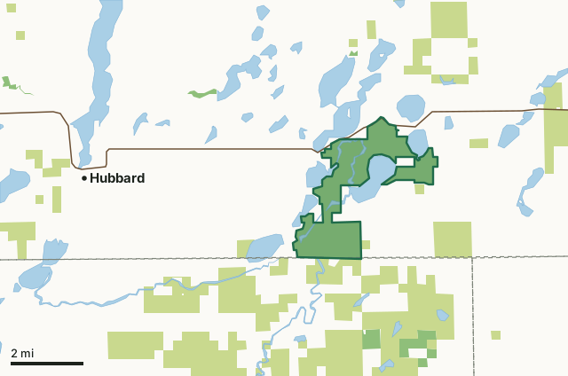
State wildlife management areasState forest and other DNR landCrow Wing Chain WMACounty lineLakeHighway
| Size | 3,334 acres |
|---|---|
| Counties | Hubbard County and Wadena County |
| Deer Permit Area | DPA 246, DPA 259 |
| DNR lists for hunting | deer, ducks and geese, ruffed grouse and other forest upland birds, bear and small game |
| Nearest town (DNR) | Hubbard |
| DNR area office | Park Rapids |
| Nearest towns | Hubbard (6 mi), Nevis (7 mi) and Park Rapids (10 mi) |
What is Crow Wing Chain WMA like?
This WMA is a complex of lakes, wetlands, old fields, and forest along the Crow Wing River. Half of the WMA is forested with aspen, jack pine, red pines, white pines, and oaks. The remainder has many acres of emergent wetlands and lowland brush.
The land was donated with the stipulation that the red and white pines wouldn't be harvested. Major management emphasis includes forest and brushland regeneration and wetland habitat management and enhancement for waterfowl nesting and food production. John Brown acquired 2770 acres in the 1960s, which were donated to The Nature Conservancy in 1976, and then given to the State of MN. There are many game species available, along with non-game viewing opportunities such as pileated woodpeckers, broad-winged hawks, and warblers. Includes a candidate old growth northern hardwood stand on the southeast side of 2nd Crow Wing Lake.
In the DNR's words, from its wildlife management area data.
What can you hunt on Crow Wing Chain WMA?
The DNR's WMA data lists deer, ducks and geese, ruffed grouse and other forest upland birds, bear and small game for Crow Wing Chain WMA. Each follows the statewide season and, for deer, the bag limit of the permit area.
What are the rules on Crow Wing Chain WMA?
Open to hunting and trapping in the regular seasons under the DNR's statewide WMA rules.
How many deer are taken around Crow Wing Chain WMA?
Crow Wing Chain WMA lies in 2 deer permit areas. The DNR registered 3,143 deer in DPA 246 in 2025, against 2,624 in 2024.
| DPA | Crow Wing Chain WMA acres in it | Deer, 2025 | Deer, 2024 | Deer, 2023 |
|---|---|---|---|---|
| DPA 246 | 3,330 | 3,143 | 2,624 | 2,394 |
| DPA 259 | 4 | 1,643 | 1,329 | 1,266 |
Harvest for the whole deer permit area, not the WMA alone: Minnesota DNR Deer Harvest Reports (2021 to 2025, 2025 report).
How do you get to Crow Wing Chain WMA?
From Hubbard, go east 8 miles on MN Highway 87. There are 7 parking areas located along the border of the WMA.
An extensive system of hunter walking trails and several field roads provide good access. There are two water accesses, 1 on Palmer Lake and 1 on the Crow Wing River near the center of the unit. Wheel chair access to the unit is moderate to difficult.
Nearest towns: Hubbard (6 miles), Nevis (7 miles), Park Rapids (10 miles) and Menahga (11 miles). Highways within 5 miles: MN 87 and MN 64.
What other public land is near Crow Wing Chain WMA?
DNR WMAs within 10 miles:
- Huntersville WMA: 521 acres, 1.9 miles away
- Burgen Lake Prairie WMA: 2,322 acres, 5 miles away
- Yaeger Lake WMA: 1,148 acres, 6.8 miles away
- Nuthatch WMA: 2,167 acres, 7.8 miles away
- Menahga WMA: 353 acres, 9.2 miles away
Public land within 3 miles of Crow Wing Chain WMA
Counting Crow Wing Chain WMA itself, 11,350 of the 47,479 acres within 3 miles of its boundary are public land open to the public (23.9%), by USGS PAD-US 4.1 (fee land open to the public).
| Manager | Acres within 3 miles |
|---|---|
| State forest and other DNR land | 7,550 |
| State wildlife management areas | 3,800 |
Questions hunters ask
Where is Crow Wing Chain WMA?
In Hubbard and Wadena counties, near Hubbard. The DNR's directions: From Hubbard, go east 8 miles on MN Highway 87. There are 7 parking areas located along the border of the WMA.
Which deer permit area is Crow Wing Chain WMA in?
DPA 246 (3,330 acres) and DPA 259 (4 acres). Each part follows its own permit area's bag limit.
How much public land is around Crow Wing Chain WMA?
11,350 acres within 3 miles of its boundary, Crow Wing Chain WMA included, by PAD-US 4.1. 5 other WMAs are within 10 miles, the closest Huntersville WMA (1.9 miles).
Get a Minnesota hunt plan when they open
Hunt plans for Minnesota are coming. Join the list and you'll hear first. The first 50 hunters in each new state get their plan free.
Until then, the free FilledTag app for iPhone has a map that works in every state, Minnesota included.
Where these facts come from
- Area description, species, rules and directions: DNR, Crow Wing Chain WMA; Minnesota DNR Wildlife Management Area boundaries, publicly accessible.
- Boundary and acres: the DNR's map layer above. Surrounding public land: USGS PAD-US 4.1 (fee land open to the public).
- Deer harvest: Minnesota DNR Deer Harvest Reports (2021 to 2025, 2025 report).
FilledTag is not part of the Minnesota Department of Natural Resources. Check the DNR's rules and posted signs before you go.
Minnesota hunting Hubbard County Wadena County DPA 246 DPA 259