Crow Wing River Corridor Wildlife Management Area: hunting and access
Crow Wing River Corridor Wildlife Management Area is 750 acres of state land managed by the Minnesota DNR in Wadena County, near Nimrod, inside Deer Permit Area 246. The DNR's WMA data lists deer, wild turkey, ducks and geese, ruffed grouse and other forest upland birds, bear and small game for it. Hunters registered 3,143 deer in DPA 246 in 2025.
Data updated October 2026. Area facts: the DNR's wildlife management area data, read 2026-10. Harvest: DNR Deer Harvest Reports, 2021 to 2025.
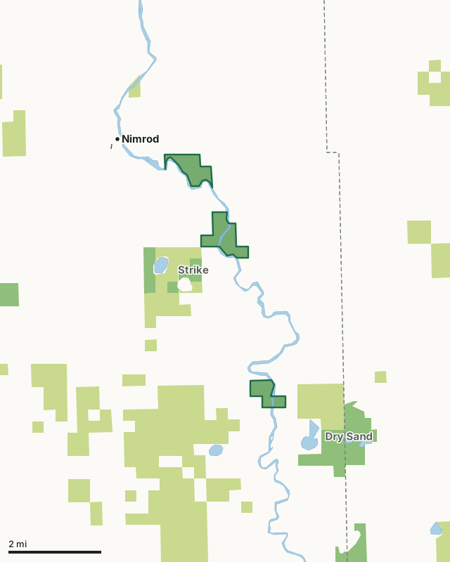
State wildlife management areasState forest and other DNR landCrow Wing River Corridor WMACounty lineLakeHighway
| Size | 750 acres in 3 pieces |
|---|---|
| County | Wadena County |
| Deer Permit Area | DPA 246 |
| DNR lists for hunting | deer, wild turkey, ducks and geese, ruffed grouse and other forest upland birds, bear and small game |
| Nearest town (DNR) | Nimrod |
| DNR area office | Park Rapids |
| Special restrictions | Yes, see the rules below |
| Nearest towns | Nimrod (next to it), Sebeka (11 mi) and Staples (12 mi) |
What is Crow Wing River Corridor WMA like?
This WMA primarily consists of forested habitat along the banks of the Crow Wing River. Purchased from Potlatch in 2016, the unit contains some open fields, which were the site of former pine plantations. Jack pine woodland restoration is a primary management goal across this unit.
In the DNR's words, from its wildlife management area data.
What can you hunt on Crow Wing River Corridor WMA?
The DNR's WMA data lists deer, wild turkey, ducks and geese, ruffed grouse and other forest upland birds, bear and small game for Crow Wing River Corridor WMA. Each follows the statewide season and, for deer, the bag limit of the permit area.
What are the rules on Crow Wing River Corridor WMA?
Open to hunting and trapping in the regular seasons under the DNR's statewide WMA rules.
Special restriction the DNR lists for Crow Wing River Corridor WMA: There is currently no access to the east side of the middle unit, except by river. The east side of the south unit is accessible by minimum maintenance road; however, there is no designated parking area. Please pull to the side of the road to park.
How many deer are taken around Crow Wing River Corridor WMA?
Crow Wing River Corridor WMA lies in Deer Permit Area 246. The DNR registered 3,143 deer in DPA 246 in 2025, against 2,624 in 2024.
| DPA | Crow Wing River Corridor WMA acres in it | Deer, 2025 | Deer, 2024 | Deer, 2023 |
|---|---|---|---|---|
| DPA 246 | 750 | 3,143 | 2,624 | 2,394 |
Harvest for the whole deer permit area, not the WMA alone: Minnesota DNR Deer Harvest Reports (2021 to 2025, 2025 report).
How do you get to Crow Wing River Corridor WMA?
North unit: from Nimrod travel east 1.5 miles on CR 139 (280th Street). Parking area will be on the south side of the road. Middle unit: travel south out of Nimrod on CR 12 (280th Street). On the south side of Nimrod turn left onto CR 26. Travel south on CR 26 for 1 mile to CR 138 (270th Street). Turn left onto CR 138. In 2 miles CR 138 will turn south. Continue south on CR 138 for 1 mile. Parking area will be on the left side of the road. South unit (west side of river): travel south out of Nimrod on CR 12 (280th Street). On the south side of Nimrod turn left onto CR 26. Travel south on CR 26 for 5 miles. Turn left onto CR 137 (230th Street). Continue east for 3 miles, cross over Wilderness Drive onto the unit. Parking will be 0.3 miles east of CR 137 and Wilderness Drive intersection. South unit (east side of river): travel south out of Oylen on CR 7 for 1.3 miles. Turn right onto the unnamed minimum maintenance road across from 230th street. In 0.3 miles the minimum maintenance road will curve south, continue south on the road 0.25 miles to the unit.
Hunter walking trails and former logging trails provide good access to visitors. Wheel chair access to the unit is moderate to difficult. Primitive river access points are located on the north unit. Visitors can easily access the river from parking areas in the northwest and southeast sides of the north unit. The northwest parking area is gated and would require a short walk/portage to the river.
Nearest towns: Nimrod (next to it), Sebeka (11 miles), Staples (12 miles) and Aldrich (13 miles).
What other public land is near Crow Wing River Corridor WMA?
DNR WMAs within 10 miles:
- Strike WMA: 300 acres, next to it
- Dry Sand WMA: 800 acres, 0.9 miles away
- Farnham Lake WMA: 256 acres, 2.9 miles away
- North Germany WMA: 278 acres, 4 miles away
- Burgen Lake Prairie WMA: 2,322 acres, 4.5 miles away
- Yaeger Lake WMA: 1,148 acres, 6.5 miles away
Public land within 3 miles of Crow Wing River Corridor WMA
Counting Crow Wing River Corridor WMA itself, 6,122 of the 45,579 acres within 3 miles of its boundary are public land open to the public (13.4%), by USGS PAD-US 4.1 (fee land open to the public).
| Manager | Acres within 3 miles |
|---|---|
| State forest and other DNR land | 4,264 |
| State wildlife management areas | 1,858 |
Questions hunters ask
Where is Crow Wing River Corridor WMA?
In Wadena County, near Nimrod. The DNR's directions: North unit: from Nimrod travel east 1.5 miles on CR 139 (280th Street). Parking area will be on the south side of the road. Middle unit: travel south out of Nimrod on CR 12 (280th Street). On the south side of Nimrod turn left onto CR 26. Travel south on CR 26 for 1 mile to CR 138 (270th Street). Turn left onto CR 138. In 2 miles CR 138 will turn south. Continue south on CR 138 for 1 mile. Parking area will be on the left side of the road. South unit (west side of river): travel south out of Nimrod on CR 12 (280th Street). On the south side of Nimrod turn left onto CR 26. Travel south on CR 26 for 5 miles. Turn left onto CR 137 (230th Street). Continue east for 3 miles, cross over Wilderness Drive onto the unit. Parking will be 0.3 miles east of CR 137 and Wilderness Drive intersection. South unit (east side of river): travel south out of Oylen on CR 7 for 1.3 miles. Turn right onto the unnamed minimum maintenance road across from 230th street. In 0.3 miles the minimum maintenance road will curve south, continue south on the road 0.25 miles to the unit.
Which deer permit area is Crow Wing River Corridor WMA in?
Deer Permit Area 246. Its bag limit and firearms dates apply.
How much public land is around Crow Wing River Corridor WMA?
6,122 acres within 3 miles of its boundary, Crow Wing River Corridor WMA included, by PAD-US 4.1. 6 other WMAs are within 10 miles, the closest Strike WMA (next to it).
Get a Minnesota hunt plan when they open
Hunt plans for Minnesota are coming. Join the list and you'll hear first. The first 50 hunters in each new state get their plan free.
Until then, the free FilledTag app for iPhone has a map that works in every state, Minnesota included.
Where these facts come from
- Area description, species, rules and directions: DNR, Crow Wing River Corridor WMA; Minnesota DNR Wildlife Management Area boundaries, publicly accessible.
- Boundary and acres: the DNR's map layer above. Surrounding public land: USGS PAD-US 4.1 (fee land open to the public).
- Deer harvest: Minnesota DNR Deer Harvest Reports (2021 to 2025, 2025 report).
FilledTag is not part of the Minnesota Department of Natural Resources. Check the DNR's rules and posted signs before you go.