Dalbo Wildlife Management Area: hunting and access
Dalbo Wildlife Management Area is 3,365 acres of state land managed by the Minnesota DNR in Isanti and Kanabec counties, near Dalbo, inside Deer Permit Area 225. The DNR's WMA data lists deer, wild turkey, pheasants, ducks and geese, ruffed grouse and other forest upland birds, bear and small game for it. Hunters registered 5,598 deer in DPA 225 in 2025.
Data updated October 2026. Area facts: the DNR's wildlife management area data, read 2026-10. Harvest: DNR Deer Harvest Reports, 2021 to 2025.
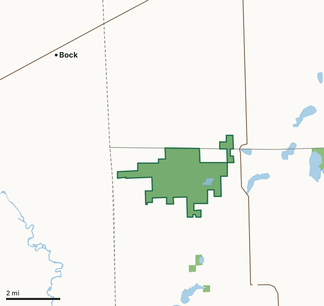
State wildlife management areasDalbo WMACounty lineLakeHighway
| Size | 3,365 acres in 2 pieces |
|---|---|
| Counties | Isanti County and Kanabec County |
| Deer Permit Area | DPA 225 |
| DNR lists for hunting | deer, wild turkey, pheasants, ducks and geese, ruffed grouse and other forest upland birds, bear and small game |
| Nearest town (DNR) | Dalbo |
| DNR area office | Cambridge |
| Special restrictions | Yes, see the rules below |
| Nearest towns | Bock (5 mi), Ogilvie (6 mi) and Pease (7 mi) |
What is Dalbo WMA like?
This WMA consists of a diversity of upland/lowland forests, brushlands, grasslands, and wetlands interspersed with croplands. There is also a 200 acre wild rice lake (Krone Lake ) within the unit boundaries.
This unit is basically a roadless area with parking lots strategically placed on the north and south boundaries. There are good opportunities to view wildlife from roads in open areas and on the lake.
In the DNR's words, from its wildlife management area data.
What can you hunt on Dalbo WMA?
The DNR's WMA data lists deer, wild turkey, pheasants, ducks and geese, ruffed grouse and other forest upland birds, bear and small game for Dalbo WMA. Each follows the statewide season and, for deer, the bag limit of the permit area.
What are the rules on Dalbo WMA?
Open to hunting and trapping in the regular seasons under the DNR's statewide WMA rules.
Special restriction the DNR lists for Dalbo WMA: Closed to Sharptail Grouse hunting. Be careful to not shoot a Sharptail when Pheasant or Ruffed Grouse hunting.
How many deer are taken around Dalbo WMA?
Dalbo WMA lies in Deer Permit Area 225. The DNR registered 5,598 deer in DPA 225 in 2025, against 5,038 in 2024.
| DPA | Dalbo WMA acres in it | Deer, 2025 | Deer, 2024 | Deer, 2023 |
|---|---|---|---|---|
| DPA 225 | 3,365 | 5,598 | 5,038 | 4,326 |
Harvest for the whole deer permit area, not the WMA alone: Minnesota DNR Deer Harvest Reports (2021 to 2025, 2025 report).
How do you get to Dalbo WMA?
From Dalbo, go 2 1/2 miles N on SH 47 then 3 1/2 miles W on CSAH 16.
Nearest towns: Bock (5 miles), Ogilvie (6 miles), Pease (7 miles) and Milaca (7 miles). Highways within 5 miles: MN 47.
What other public land is near Dalbo WMA?
DNR WMAs within 10 miles:
- Dobe WMA: 99 acres, 1.4 miles away
- Cranberry WMA: 317 acres, 2.9 miles away
- Stanchfield WMA: 38 acres, 5.5 miles away
- Tosher Creek WMA: 323 acres, 6.4 miles away
- Bolger WMA: 41 acres, 6.7 miles away
- Spectacle WMA: 505 acres, 8.9 miles away
Public land within 3 miles of Dalbo WMA
Counting Dalbo WMA itself, 3,518 of the 45,645 acres within 3 miles of its boundary are public land open to the public (7.7%), by USGS PAD-US 4.1 (fee land open to the public).
| Manager | Acres within 3 miles |
|---|---|
| State wildlife management areas | 3,518 |
Questions hunters ask
Where is Dalbo WMA?
In Isanti and Kanabec counties, near Dalbo. The DNR's directions: From Dalbo, go 2 1/2 miles N on SH 47 then 3 1/2 miles W on CSAH 16.
Which deer permit area is Dalbo WMA in?
Deer Permit Area 225. Its bag limit and firearms dates apply.
How much public land is around Dalbo WMA?
3,518 acres within 3 miles of its boundary, Dalbo WMA included, by PAD-US 4.1. 6 other WMAs are within 10 miles, the closest Dobe WMA (1.4 miles).
Get a Minnesota hunt plan when they open
Hunt plans for Minnesota are coming. Join the list and you'll hear first. The first 50 hunters in each new state get their plan free.
Until then, the free FilledTag app for iPhone has a map that works in every state, Minnesota included.
Where these facts come from
- Area description, species, rules and directions: DNR, Dalbo WMA; Minnesota DNR Wildlife Management Area boundaries, publicly accessible.
- Boundary and acres: the DNR's map layer above. Surrounding public land: USGS PAD-US 4.1 (fee land open to the public).
- Deer harvest: Minnesota DNR Deer Harvest Reports (2021 to 2025, 2025 report).
FilledTag is not part of the Minnesota Department of Natural Resources. Check the DNR's rules and posted signs before you go.