Erskine Wildlife Management Area: hunting and access
Erskine Wildlife Management Area is 1,220 acres of state land managed by the Minnesota DNR in Polk County, near Erskine, inside Deer Permit Area 257. The DNR's WMA data lists deer, ducks and geese, ruffed grouse and other forest upland birds, sharp-tailed grouse, bear and small game for it. Hunters registered 979 deer in DPA 257 in 2025.
Data updated October 2026. Area facts: the DNR's wildlife management area data, read 2026-10. Harvest: DNR Deer Harvest Reports, 2021 to 2025.
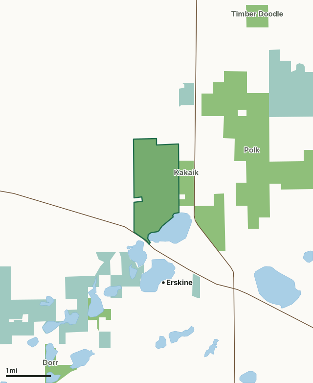
State wildlife management areasNational wildlife refuges and waterfowl production areasErskine WMACounty lineLakeHighway
| Size | 1,220 acres |
|---|---|
| County | Polk County |
| Deer Permit Area | DPA 257 |
| DNR lists for hunting | deer, ducks and geese, ruffed grouse and other forest upland birds, sharp-tailed grouse, bear and small game |
| Nearest town (DNR) | Erskine |
| DNR area office | Thief River Falls |
| Nearest towns | Erskine (next to it), Mentor (5 mi) and McIntosh (7 mi) |
What is Erskine WMA like?
This WMA consists of open terrain with wet prairie, sedge meadow, brush thickets, and scattered groves of aspen. The management of the unit is to preserve the aspen parkland habitat and the diversity of the plant and animal species.
The unit is adjacent to Badger Lake and also contains several open water marshes. Seventy-five small wetland dugouts have been created on the unit. Bald eagles have nested in various places on the unit since 1987. Wildflower photography, bird and animal observation. Expect to find deer, prairie grouse, waterfowl, sandhill cranes, and woodcock. Other species include Canadian Toad and alder flycatchers, pileated woodpeckers and red-tailed hawk.
In the DNR's words, from its wildlife management area data.
What can you hunt on Erskine WMA?
The DNR's WMA data lists deer, ducks and geese, ruffed grouse and other forest upland birds, sharp-tailed grouse, bear and small game for Erskine WMA. Each follows the statewide season and, for deer, the bag limit of the permit area.
What are the rules on Erskine WMA?
Open to hunting and trapping in the regular seasons under the DNR's statewide WMA rules.
How many deer are taken around Erskine WMA?
Erskine WMA lies in Deer Permit Area 257. The DNR registered 979 deer in DPA 257 in 2025, against 928 in 2024.
| DPA | Erskine WMA acres in it | Deer, 2025 | Deer, 2024 | Deer, 2023 |
|---|---|---|---|---|
| DPA 257 | 1,220 | 979 | 928 | 872 |
Harvest for the whole deer permit area, not the WMA alone: Minnesota DNR Deer Harvest Reports (2021 to 2025, 2025 report).
How do you get to Erskine WMA?
From Erskine, go 1 1/2 miles N on CO RD 208.
Access is good with township roads on the east and west sides. Several ditch crossings are located on the west side. There is a routed wood sign identifying the unit off the east road.
Nearest towns: Erskine (next to it), Mentor (5 miles), McIntosh (7 miles) and Brooks (7 miles). Highways within 5 miles: US 59 and US 2.
What other public land is near Erskine WMA?
DNR WMAs within 10 miles:
- Kakaik WMA: 204 acres, next to it
- Polk WMA: 2,762 acres, next to it
- Bee Lake WMA: 121 acres, 1.6 miles away
- Timber Doodle WMA: 158 acres, 3 miles away
- Dorr WMA: 378 acres, 3.1 miles away
- Mentor Prairie WMA: 2,183 acres, 5.1 miles away
Public land within 3 miles of Erskine WMA
Counting Erskine WMA itself, 5,968 of the 30,905 acres within 3 miles of its boundary are public land open to the public (19.3%), by USGS PAD-US 4.1 (fee land open to the public).
| Manager | Acres within 3 miles |
|---|---|
| State wildlife management areas | 4,089 |
| National wildlife refuges and waterfowl production areas | 1,879 |
Questions hunters ask
Where is Erskine WMA?
In Polk County, near Erskine. The DNR's directions: From Erskine, go 1 1/2 miles N on CO RD 208.
Which deer permit area is Erskine WMA in?
Deer Permit Area 257. Its bag limit and firearms dates apply.
How much public land is around Erskine WMA?
5,968 acres within 3 miles of its boundary, Erskine WMA included, by PAD-US 4.1. 6 other WMAs are within 10 miles, the closest Kakaik WMA (next to it).
Get a Minnesota hunt plan when they open
Hunt plans for Minnesota are coming. Join the list and you'll hear first. The first 50 hunters in each new state get their plan free.
Until then, the free FilledTag app for iPhone has a map that works in every state, Minnesota included.
Where these facts come from
- Area description, species, rules and directions: DNR, Erskine WMA; Minnesota DNR Wildlife Management Area boundaries, publicly accessible.
- Boundary and acres: the DNR's map layer above. Surrounding public land: USGS PAD-US 4.1 (fee land open to the public).
- Deer harvest: Minnesota DNR Deer Harvest Reports (2021 to 2025, 2025 report).
FilledTag is not part of the Minnesota Department of Natural Resources. Check the DNR's rules and posted signs before you go.