Kimberly Marsh Wildlife Management Area: hunting and access
Kimberly Marsh Wildlife Management Area is 10,564 acres of state land managed by the Minnesota DNR in Aitkin County, near McGregor, inside Deer Permit Areas 155 and 171. The DNR's WMA data lists deer, ducks and geese, ruffed grouse and other forest upland birds, bear and small game for it. Hunters registered 1,134 deer in DPA 155 in 2025.
Data updated October 2026. Area facts: the DNR's wildlife management area data, read 2026-10. Harvest: DNR Deer Harvest Reports, 2021 to 2025.
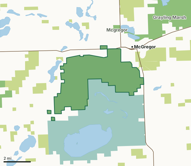
State wildlife management areasState forest and other DNR landNational wildlife refuges and waterfowl production areasKimberly Marsh WMACounty lineLakeHighway
| Size | 10,564 acres in 4 pieces |
|---|---|
| County | Aitkin County |
| Deer Permit Area | DPA 155, DPA 171 |
| DNR lists for hunting | deer, ducks and geese, ruffed grouse and other forest upland birds, bear and small game |
| Nearest town (DNR) | McGregor |
| DNR area office | Aitkin |
| Special restrictions | Yes, see the rules below |
| Nearest towns | McGregor (next to it), Palisade (9 mi) and Tamarack (9 mi) |
What is Kimberly Marsh WMA like?
The west portion of this sub unit is low ground dominated by grass, brush and tamarack. Upland oak and aspen run through the center of this sub unit and the eastern portions are made up of old pasture. This sub unit is a low ground mix of grass, brush and jack pine growing on muskeg bog. There is an island of aspen in the northeast corner of the sub unit. This sub unit of the Kimberly WMA is mostly low ground dominated by grass and brush with some timbered islands. This sub unit adjoins a portion of the north side of the Rice Lake National Wildlife Refuge. This WMA contains 2 impoundments of about 300 acres each, along with upland timber forest types that are mainly aspen, oak, some pine. The Rice River runs through the south side of this unit with old growth quality lowland hardwoods along side it.
This sub unit was purchased as part of a planned expansion for the Main Unit of Kimberly WMA. This parcel was donated to the DNR as an addition to the Main Unit. Purchased as an expansion for the Main Unit of the Kimberly WMA. This unit is adjacent to the Rice Lake National Wildlife Refuge. The north side of this unit is a cooperative WMA with Aitkin County. This WMA is mainly managed for deer, bear, ruffed grouse, waterfowl, and open land wildlife. Deer, bear, gray squirrels, tree swallows and grasshopper sparrows may use this WMA. Deer, bear, common yellowthroats, and gray catbirds may use this WMA. Limited wildlife watching opportunities are available from the township road. Eagles and sandhill cranes nest here and can be seen from the dikes.Yellow rails and sharp-tailed sparrows nest on the east side of this unit. Good spot for short-eared owls also on the east side.
In the DNR's words, from its wildlife management area data.
What can you hunt on Kimberly Marsh WMA?
The DNR's WMA data lists deer, ducks and geese, ruffed grouse and other forest upland birds, bear and small game for Kimberly Marsh WMA. Each follows the statewide season and, for deer, the bag limit of the permit area.
What are the rules on Kimberly Marsh WMA?
Open to hunting and trapping in the regular seasons under the DNR's statewide WMA rules.
Special restriction the DNR lists for Kimberly Marsh WMA: No easy public access.
Special restriction the DNR lists for Kimberly Marsh WMA: No wild rice harvesting allowed.
How many deer are taken around Kimberly Marsh WMA?
Kimberly Marsh WMA lies in 2 deer permit areas. The DNR registered 1,134 deer in DPA 155 in 2025, against 937 in 2024.
| DPA | Kimberly Marsh WMA acres in it | Deer, 2025 | Deer, 2024 | Deer, 2023 |
|---|---|---|---|---|
| DPA 155 | 10,483 | 1,134 | 937 | 781 |
| DPA 171 | 81 | 1,165 | 1,068 | 819 |
Harvest for the whole deer permit area, not the WMA alone: Minnesota DNR Deer Harvest Reports (2021 to 2025, 2025 report).
How do you get to Kimberly Marsh WMA?
From McGregor go 4 miles W. on Hwy. 210, 5 miles S. on 257th Avenue, left on 362nd Lane 0.5 miles. From McGregor, go 1 mile W on HWY 210 then turn N on 240th Place, the WMA is on the West side of road. From McGregor 4 miles W. on Hwy. 210, 5 miles S. on 257th Avenue, left on 362nd Lane 1 mile. From McGregor: North access: 2 miles W on Hwy. 210, S. 0.5 miles on 240th Place. Impoundment access: 4 miles W. on Hwy 210, 4 miles S. on 257th Avenue, access road to east.
There is no direct access to this unit. Public access is available across county tax forfeit lands to the west. Public access is available only through the Rice Lake National Wildlife Refuge. Wheelchair access is limited the parking lot at the impoundment and at the access trail on the north end of this unit.
Nearest towns: McGregor (next to it), Palisade (9 miles), Tamarack (9 miles) and Aitkin (13 miles). Highways within 5 miles: MN 210 and MN 65.
What other public land is near Kimberly Marsh WMA?
DNR WMAs within 10 miles:
- Mcgregor WMA: 651 acres, 1 mile away
- Grayling Marsh WMA: 9,960 acres, 2.1 miles away
- Newstrom Lake WMA: 796 acres, 2.7 miles away
- Lawler WMA: 235 acres, 5.2 miles away
- Woross WMA: 620 acres, 6.4 miles away
- Aitkin WMA: 3,415 acres, 6.6 miles away
Public land within 3 miles of Kimberly Marsh WMA
Counting Kimberly Marsh WMA itself, 33,290 of the 70,747 acres within 3 miles of its boundary are public land open to the public (47.1%), by USGS PAD-US 4.1 (fee land open to the public).
| Manager | Acres within 3 miles |
|---|---|
| National wildlife refuges and waterfowl production areas | 15,511 |
| State wildlife management areas | 11,838 |
| State forest and other DNR land | 5,941 |
Questions hunters ask
Where is Kimberly Marsh WMA?
In Aitkin County, near McGregor. The DNR's directions: From McGregor go 4 miles W. on Hwy. 210, 5 miles S. on 257th Avenue, left on 362nd Lane 0.5 miles. From McGregor, go 1 mile W on HWY 210 then turn N on 240th Place, the WMA is on the West side of road. From McGregor 4 miles W. on Hwy. 210, 5 miles S. on 257th Avenue, left on 362nd Lane 1 mile. From McGregor: North access: 2 miles W on Hwy. 210, S. 0.5 miles on 240th Place. Impoundment access: 4 miles W. on Hwy 210, 4 miles S. on 257th Avenue, access road to east.
Which deer permit area is Kimberly Marsh WMA in?
DPA 155 (10,483 acres) and DPA 171 (81 acres). Each part follows its own permit area's bag limit.
How much public land is around Kimberly Marsh WMA?
33,290 acres within 3 miles of its boundary, Kimberly Marsh WMA included, by PAD-US 4.1. 6 other WMAs are within 10 miles, the closest Mcgregor WMA (1 mile).
Get a Minnesota hunt plan when they open
Hunt plans for Minnesota are coming. Join the list and you'll hear first. The first 50 hunters in each new state get their plan free.
Until then, the free FilledTag app for iPhone has a map that works in every state, Minnesota included.
Where these facts come from
- Area description, species, rules and directions: DNR, Kimberly Marsh WMA; Minnesota DNR Wildlife Management Area boundaries, publicly accessible.
- Boundary and acres: the DNR's map layer above. Surrounding public land: USGS PAD-US 4.1 (fee land open to the public).
- Deer harvest: Minnesota DNR Deer Harvest Reports (2021 to 2025, 2025 report).
FilledTag is not part of the Minnesota Department of Natural Resources. Check the DNR's rules and posted signs before you go.