Magaksica Wildlife Management Area: hunting and access
Magaksica Wildlife Management Area is 169 acres of state land managed by the Minnesota DNR in Freeborn County, near Albert Lea, inside Deer Permit Area 254. The DNR's WMA data lists deer, wild turkey, pheasants, ducks and geese, mourning doves and small game for it. Hunters registered 1,373 deer in DPA 254 in 2025.
Data updated October 2026. Area facts: the DNR's wildlife management area data, read 2026-10. Harvest: DNR Deer Harvest Reports, 2021 to 2025.
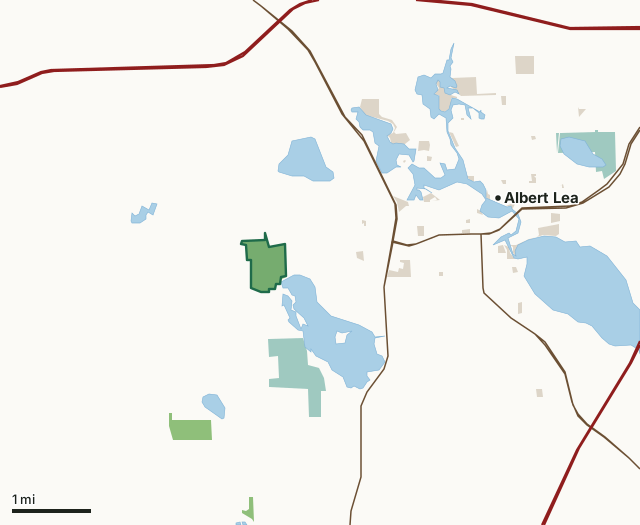
State wildlife management areasNational wildlife refuges and waterfowl production areasCounty, city and regional landMagaksica WMACounty lineLakeHighway
| Size | 169 acres |
|---|---|
| County | Freeborn County |
| Deer Permit Area | DPA 254 |
| DNR lists for hunting | deer, wild turkey, pheasants, ducks and geese, mourning doves and small game |
| Nearest town (DNR) | Albert Lea |
| DNR area office | Owatonna |
| Special restrictions | Yes, see the rules below |
| Nearest towns | Albert Lea (3 mi), Conger (5 mi) and Twin Lakes (5 mi) |
What is Magaksica WMA like?
This WMA encompasses much of the Mud Lake basin, a large marsh with a fringe of dense cattails and other robust emergent vegetation. Some of this marshy fringe is comprised of floating bog. The adjacent lands are gently rolling lands and bluffs overlooking Mud and Pickerel Lakes and Shoff Creek. These lands support a variety of habitats including grasslands, woodlands and small wetlands.
An electric fish barrier was installed at the outlet of Mud Lake and is maintained by the Shell Rock Watershed District to control carp access to Mud and Pickerel Lakes. Excluding these destructive fish from these lakes helps improve aquatic habitats and water quality. The dam for Pickerel Lake, also located on this WMA, was reconstructed by the Shell Rock Watershed District. Portions of this wildlife management area have been gifted to the Department of Natural Resources by partners in conservation including a 59-acre tract from the Wetlands America Trust, Inc. and a 22-acre tract from the Shell Rock River Watershed District. Acquisition and management of this wildlife area benefitted from special funding from the Outdoor Heritage Fund, North American Waterfowl Conservation Act, the Environment and Natural Resources Trust Fund and the Shell Rock Watershed District.
In the DNR's words, from its wildlife management area data.
What can you hunt on Magaksica WMA?
The DNR's WMA data lists deer, wild turkey, pheasants, ducks and geese, mourning doves and small game for Magaksica WMA. Each follows the statewide season and, for deer, the bag limit of the permit area.
What are the rules on Magaksica WMA?
Open to hunting and trapping in the regular seasons under the DNR's statewide WMA rules.
Special restriction the DNR lists for Magaksica WMA: There is a 500' "no shooting" buffer along the neighborhoods bordering the the WMA.
How many deer are taken around Magaksica WMA?
Magaksica WMA lies in Deer Permit Area 254. The DNR registered 1,373 deer in DPA 254 in 2025, against 1,340 in 2024.
| DPA | Magaksica WMA acres in it | Deer, 2025 | Deer, 2024 | Deer, 2023 |
|---|---|---|---|---|
| DPA 254 | 169 | 1,373 | 1,340 | 1,346 |
Harvest for the whole deer permit area, not the WMA alone: Minnesota DNR Deer Harvest Reports (2021 to 2025, 2025 report).
How do you get to Magaksica WMA?
From Albert Lea, 2 miles W. on CSAH 46, then 0.25 miles S. Co. Rd. 71.
The primary parking area for this WMA is located east of County Road 71 opposite the intersection of County 71 and 200th Street. There is a primitive carry down access trail to the marshy fringe of Mud Lake from this parking area. A secondary access and parking area is located south of CSAH 46 where a small grass-surface parking area provides a pull-off for a vehicle or two. A walking trail leads south to the main body of the WMA and a crossing of Shoff Creek. A small mowed pullout is also provided in the southeastern corner of the WMA along Oakridge Road. The WMA has shoreline on Pickerel Lake, but no developed water accesses to the lake are located on the WMA. An improved Water Access for Pickerel Lake is located off of U.S. Highway 69 in the southeastern corner of the lake.
Nearest towns: Albert Lea (3 miles), Conger (5 miles), Twin Lakes (5 miles) and Manchester (5 miles). Highways within 5 miles: I-90, US 65, I-35, MN 13 and US 69.
What other public land is near Magaksica WMA?
DNR WMAs within 10 miles:
- Upper Twin Lake WMA: 99 acres, 1.7 miles away
- Halls Lake WMA: 152 acres, 4.3 miles away
- Ann & Leo Donahue WMA: 112 acres, 4.9 miles away
- Bear WMA: 64 acres, 6.1 miles away
- Manchester WMA: 113 acres, 7.5 miles away
- Panicum Prairie WMA: 1,049 acres, 9.3 miles away
Public land within 3 miles of Magaksica WMA
Counting Magaksica WMA itself, 736 of the 22,404 acres within 3 miles of its boundary are public land open to the public (3.3%), by USGS PAD-US 4.1 (fee land open to the public).
| Manager | Acres within 3 miles |
|---|---|
| State wildlife management areas | 272 |
| National wildlife refuges and waterfowl production areas | 244 |
| County, city and regional land | 220 |
Questions hunters ask
Where is Magaksica WMA?
In Freeborn County, near Albert Lea. The DNR's directions: From Albert Lea, 2 miles W. on CSAH 46, then 0.25 miles S. Co. Rd. 71.
Which deer permit area is Magaksica WMA in?
Deer Permit Area 254. Its bag limit and firearms dates apply.
How much public land is around Magaksica WMA?
736 acres within 3 miles of its boundary, Magaksica WMA included, by PAD-US 4.1. 6 other WMAs are within 10 miles, the closest Upper Twin Lake WMA (1.7 miles).
Get a Minnesota hunt plan when they open
Hunt plans for Minnesota are coming. Join the list and you'll hear first. The first 50 hunters in each new state get their plan free.
Until then, the free FilledTag app for iPhone has a map that works in every state, Minnesota included.
Where these facts come from
- Area description, species, rules and directions: DNR, Magaksica WMA; Minnesota DNR Wildlife Management Area boundaries, publicly accessible.
- Boundary and acres: the DNR's map layer above. Surrounding public land: USGS PAD-US 4.1 (fee land open to the public).
- Deer harvest: Minnesota DNR Deer Harvest Reports (2021 to 2025, 2025 report).
FilledTag is not part of the Minnesota Department of Natural Resources. Check the DNR's rules and posted signs before you go.