Mille Lacs Wildlife Management Area: hunting and access
Mille Lacs Wildlife Management Area is 38,708 acres of state land managed by the Minnesota DNR in Mille Lacs and Kanabec counties, near Onamia, inside Deer Permit Areas 152 and 157. The DNR's WMA data lists deer, wild turkey, ducks and geese, ruffed grouse and other forest upland birds, bear and small game for it. Hunters registered 153 deer in DPA 152 in 2025.
Data updated October 2026. Area facts: the DNR's wildlife management area data, read 2026-10. Harvest: DNR Deer Harvest Reports, 2021 to 2025.
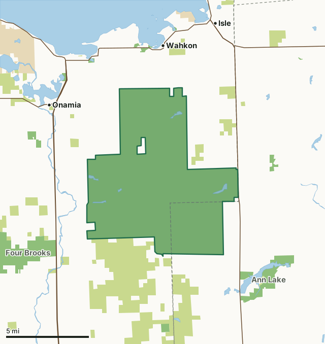
State wildlife management areasState forest and other DNR landState parksMille Lacs WMACounty lineLakeHighway
| Size | 38,708 acres |
|---|---|
| Counties | Mille Lacs County and Kanabec County |
| Deer Permit Area | DPA 152, DPA 157 |
| DNR lists for hunting | deer, wild turkey, ducks and geese, ruffed grouse and other forest upland birds, bear and small game |
| Nearest town (DNR) | Onamia |
| DNR area office | Mille Lacs WMA |
| Nearest towns | Wahkon (3 mi), Onamia (4 mi) and Isle (4 mi) |
What is Mille Lacs WMA like?
Mille Lacs WMA was established in 1949. Sixty percent of the WMA is forested, with the remainder of land being wetlands, bogs and forest openings. Many fields around the area are planted with corn or maintained as hay land.
Forests on the WMA are managed to promote an interspersion of different aged plant communities and enhance wildlife diversity. Logging of hardwood and aspen stands create forest openings and edges between existing vegetation types.
In the DNR's words, from its wildlife management area data.
What can you hunt on Mille Lacs WMA?
The DNR's WMA data lists deer, wild turkey, ducks and geese, ruffed grouse and other forest upland birds, bear and small game for Mille Lacs WMA. Each follows the statewide season and, for deer, the bag limit of the permit area.
What are the rules on Mille Lacs WMA?
Open to hunting and trapping in the regular seasons under the DNR's statewide WMA rules.
Mille Lacs WMA is one of the WMAs where every trapper needs a permit from the area wildlife manager.
Highway-licensed vehicles may drive the established roads on Mille Lacs WMA; on most WMAs vehicles are kept to designated routes.
How many deer are taken around Mille Lacs WMA?
Mille Lacs WMA lies in 2 deer permit areas. The DNR registered 153 deer in DPA 152 in 2025, against 119 in 2024.
| DPA | Mille Lacs WMA acres in it | Deer, 2025 | Deer, 2024 | Deer, 2023 |
|---|---|---|---|---|
| DPA 152 | 38,693 | 153 | 119 | 127 |
| DPA 157 | 15 | 4,606 | 4,255 | 3,716 |
Harvest for the whole deer permit area, not the WMA alone: Minnesota DNR Deer Harvest Reports (2021 to 2025, 2025 report).
How do you get to Mille Lacs WMA?
From Onamia travel 7 miles south on SR 169. Then travel 2 miles east on 290 Street. WMA Headquarters will be 0.2 miles north on 100th Avenue, on the east side of the gravel road.
Wheelchair access is limited to adjacent county roads and mowed and gravel parking areas, which may be muddy during wet weather.
Nearest towns: Wahkon (3 miles), Onamia (4 miles), Isle (4 miles) and Ogilvie (7 miles). Highways within 5 miles: US 169, MN 27 and MN 47.
What other public land is near Mille Lacs WMA?
DNR WMAs within 10 miles:
- Ann Lake WMA: 1,876 acres, 1.4 miles away
- Four Brooks WMA: 4,201 acres, 1.9 miles away
- Ivan Jindra Memorial WMA: 243 acres, 2.9 miles away
- Onamia Lake WMA: 77 acres, 3.3 miles away
- Groundhouse WMA: 162 acres, 4.1 miles away
- Tosher Creek WMA: 323 acres, 8.1 miles away
Public land within 3 miles of Mille Lacs WMA
Counting Mille Lacs WMA itself, 50,214 of the 126,111 acres within 3 miles of its boundary are public land open to the public (39.8%), by USGS PAD-US 4.1 (fee land open to the public).
| Manager | Acres within 3 miles |
|---|---|
| State wildlife management areas | 40,444 |
| State forest and other DNR land | 9,770 |
Questions hunters ask
Where is Mille Lacs WMA?
In Mille Lacs and Kanabec counties, near Onamia. The DNR's directions: From Onamia travel 7 miles south on SR 169. Then travel 2 miles east on 290 Street. WMA Headquarters will be 0.2 miles north on 100th Avenue, on the east side of the gravel road.
Which deer permit area is Mille Lacs WMA in?
DPA 152 (38,693 acres) and DPA 157 (15 acres). Each part follows its own permit area's bag limit.
How much public land is around Mille Lacs WMA?
50,214 acres within 3 miles of its boundary, Mille Lacs WMA included, by PAD-US 4.1. 6 other WMAs are within 10 miles, the closest Ann Lake WMA (1.4 miles).
Get a Minnesota hunt plan when they open
Hunt plans for Minnesota are coming. Join the list and you'll hear first. The first 50 hunters in each new state get their plan free.
Until then, the free FilledTag app for iPhone has a map that works in every state, Minnesota included.
Where these facts come from
- Area description, species, rules and directions: DNR, Mille Lacs WMA; Minnesota DNR Wildlife Management Area boundaries, publicly accessible.
- Boundary and acres: the DNR's map layer above. Surrounding public land: USGS PAD-US 4.1 (fee land open to the public).
- Deer harvest: Minnesota DNR Deer Harvest Reports (2021 to 2025, 2025 report).
FilledTag is not part of the Minnesota Department of Natural Resources. Check the DNR's rules and posted signs before you go.
Minnesota hunting Mille Lacs County Kanabec County DPA 152 DPA 157