Moon Valley Wildlife Management Area: hunting and access
Moon Valley Wildlife Management Area is 429 acres of state land managed by the Minnesota DNR in Olmsted County, near Genoa, inside Deer Permit Area 643. The DNR's WMA data lists deer, wild turkey, pheasants, ducks and geese, ruffed grouse and other forest upland birds, mourning doves and small game for it. Hunters registered 3,469 deer in DPA 643 in 2025.
Data updated October 2026. Area facts: the DNR's wildlife management area data, read 2026-10. Harvest: DNR Deer Harvest Reports, 2021 to 2025.
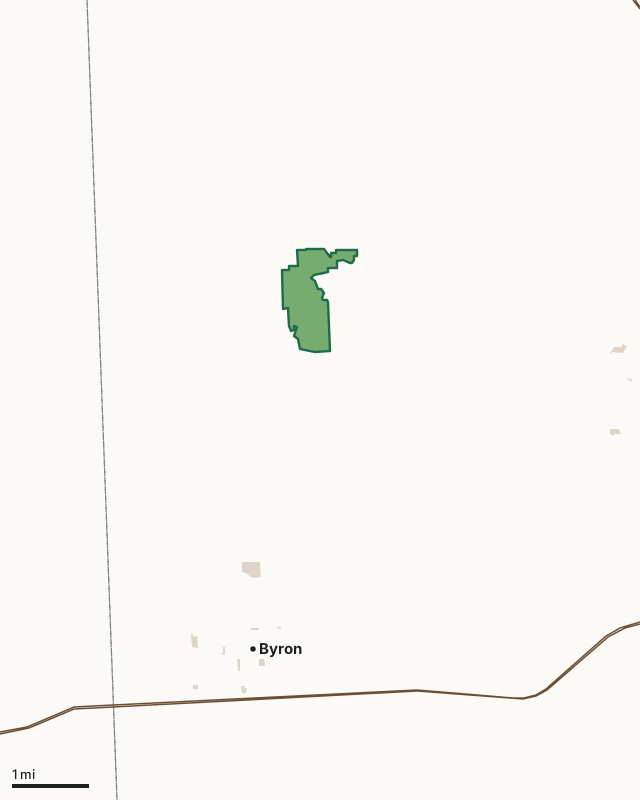
State wildlife management areasCounty, city and regional landLand trusts and other open landMoon Valley WMACounty lineHighway
| Size | 429 acres |
|---|---|
| County | Olmsted County |
| Deer Permit Area | DPA 643 |
| DNR lists for hunting | deer, wild turkey, pheasants, ducks and geese, ruffed grouse and other forest upland birds, mourning doves and small game |
| Nearest town (DNR) | Genoa |
| DNR area office | Rochester |
| Nearest towns | Byron (4 mi), Oronoco (5 mi) and Pine Island (6 mi) |
What is Moon Valley WMA like?
This WMA consists of primarily forested habitat and agricultural fields. There is a fair bit of elevation change as the property slopes down toward the river corridor flanking the south and east boundaries of the property. The forested portions of the unit include both upland and bottomland forest. The upland forest that runs through the heart of the property is high quality, with many mature tree species present including oaks. The remaining farmland on the property is in the process of being restored to native prairie or oak forest, and should be complete by spring 2026.
With support from the Outdoor Heritage Fund, this property was acquired on behalf of DNR through a joint partnership between The Nature Conservancy and Trust for Public Land. This property includes nearly 3 miles of stream frontage on the South Branch Middle Fork Zumbro River. The portion of the river that flows along the boundary of the WMA is a state water trail. This unit provides excellent opportunities for deer and turkey hunting. Pheasant hunting opportunity should increase as native prairie is restored on the property over the next couple years. Fantastic opportunities to small game hunt, forage for berries & mushrooms, and bird watch also exist.
In the DNR's words, from its wildlife management area data.
What can you hunt on Moon Valley WMA?
The DNR's WMA data lists deer, wild turkey, pheasants, ducks and geese, ruffed grouse and other forest upland birds, mourning doves and small game for Moon Valley WMA. Each follows the statewide season and, for deer, the bag limit of the permit area.
What are the rules on Moon Valley WMA?
Open to hunting and trapping in the regular seasons under the DNR's statewide WMA rules.
How many deer are taken around Moon Valley WMA?
Moon Valley WMA lies in Deer Permit Area 643. The DNR registered 3,469 deer in DPA 643 in 2025, against 3,028 in 2024.
| DPA | Moon Valley WMA acres in it | Deer, 2025 | Deer, 2024 | Deer, 2023 |
|---|---|---|---|---|
| DPA 643 | 429 | 3,469 | 3,028 | 3,039 |
Harvest for the whole deer permit area, not the WMA alone: Minnesota DNR Deer Harvest Reports (2021 to 2025, 2025 report).
How do you get to Moon Valley WMA?
From Genoa, go 0.5 miles west on 75th St NW. Address of the parking lot is 9060 75th St NW, Byron, MN 55920.
There is one developed parking area located off 75th St NW along the northern boundary of the WMA. It is approximately 0.3 miles west of the intersection of 75th St NW and where 85th St NW heads north. There is NO public access through the nearby farmyard along 75th St NW - PLEASE respect private property boundaries when accessing this unit.
Nearest towns: Byron (4 miles), Oronoco (5 miles), Pine Island (6 miles) and Mantorville (6 miles). Highways within 5 miles: US 52 and US 14.
What other public land is near Moon Valley WMA?
DNR WMAs within 10 miles:
- Izaak Walton League WMA: 121 acres, 7.4 miles away
- Roscoe WMA: 49 acres, 8.8 miles away
- Pheasants Forever WMA: 297 acres, 9.2 miles away
- Tri-cooperative WMA: 47 acres, 9.9 miles away
Public land within 3 miles of Moon Valley WMA
Counting Moon Valley WMA itself, 455 of the 26,182 acres within 3 miles of its boundary are public land open to the public (1.7%), by USGS PAD-US 4.1 (fee land open to the public).
| Manager | Acres within 3 miles |
|---|---|
| State wildlife management areas | 429 |
| County, city and regional land | 26 |
Questions hunters ask
Where is Moon Valley WMA?
In Olmsted County, near Genoa. The DNR's directions: From Genoa, go 0.5 miles west on 75th St NW. Address of the parking lot is 9060 75th St NW, Byron, MN 55920.
Which deer permit area is Moon Valley WMA in?
Deer Permit Area 643. Its bag limit and firearms dates apply.
How much public land is around Moon Valley WMA?
455 acres within 3 miles of its boundary, Moon Valley WMA included, by PAD-US 4.1. 4 other WMAs are within 10 miles, the closest Izaak Walton League WMA (7.4 miles).
Get a Minnesota hunt plan when they open
Hunt plans for Minnesota are coming. Join the list and you'll hear first. The first 50 hunters in each new state get their plan free.
Until then, the free FilledTag app for iPhone has a map that works in every state, Minnesota included.
Where these facts come from
- Area description, species, rules and directions: DNR, Moon Valley WMA; Minnesota DNR Wildlife Management Area boundaries, publicly accessible.
- Boundary and acres: the DNR's map layer above. Surrounding public land: USGS PAD-US 4.1 (fee land open to the public).
- Deer harvest: Minnesota DNR Deer Harvest Reports (2021 to 2025, 2025 report).
FilledTag is not part of the Minnesota Department of Natural Resources. Check the DNR's rules and posted signs before you go.