Mud Lake Wildlife Management Area: hunting and access
Mud Lake Wildlife Management Area is 718 acres of state land managed by the Minnesota DNR in Morrison and Clearwater counties, near Bagley, inside Deer Permit Areas 214 and 684. The DNR's WMA data lists deer, wild turkey, pheasants, ducks and geese, mourning doves and small game for it. Hunters registered 4,781 deer in DPA 214 in 2025.
Data updated October 2026. Area facts: the DNR's wildlife management area data, read 2026-10. Harvest: DNR Deer Harvest Reports, 2021 to 2025.
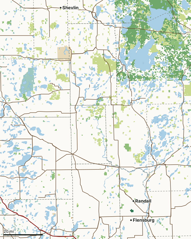
State wildlife management areasState forest and other DNR landNational forestNational wildlife refuges and waterfowl production areasOther federal landState parksCounty, city and regional landLand trusts and other open landWalk-In AccessMud Lake WMACounty lineLakeHighway
| Size | 718 acres in 2 pieces |
|---|---|
| Counties | Morrison County and Clearwater County |
| Deer Permit Area | DPA 214, DPA 684 |
| DNR lists for hunting | deer, wild turkey, pheasants, ducks and geese, mourning doves and small game |
| Nearest town (DNR) | Bagley |
| DNR area office | Park Rapids |
| Special restrictions | Yes, see the rules below |
| Nearest towns | Flensburg (4 mi), Randall (4 mi) and Sobieski (6 mi) |
What is Mud Lake WMA like?
This WMA is one of 29 small (60 acres or less), scattered WMAs in Clearwater County with 900 ft of lakeshore on the east side of Mud Lake. This 4-acre unit is surrounded by DNR Forestry Trust land. This unit is composed of black ash forest. Emergent marsh with low land grass and brush, as well as some upland forest and restored prairie. Management of this unit focuses on maintaining and improving the habitat for a diversity of native plants and wildlife, with emphasis on grassland and forested habitat.
Shoreline protection for shallow waterfowl lake is the main management focus for this unit. Access to this WMA is only available through state forest lands. Mud Lake is one of two basins in Morrison County has had a documented history of canvasback use. Waterfowl hunting opportunities exist on Mud Lake.
In the DNR's words, from its wildlife management area data.
What can you hunt on Mud Lake WMA?
The DNR's WMA data lists deer, wild turkey, pheasants, ducks and geese, mourning doves and small game for Mud Lake WMA. Each follows the statewide season and, for deer, the bag limit of the permit area.
What are the rules on Mud Lake WMA?
Open to hunting and trapping in the regular seasons under the DNR's statewide WMA rules.
Special restriction the DNR lists for Mud Lake WMA: Visitors to this unit should be aware that there is an 8 acre, 300 ft. x 1,200 ft. no firearms discharge zone along part of the west boundary of the WMA. This zone was established and posted with orange restricted area signs in 2006 to comply with M.S. 97B.001 after receiving a request by the adjoining landowner to provide relief from disturbance by firearms on livestock occupying a barn and corral close to the boundary.
How many deer are taken around Mud Lake WMA?
Mud Lake WMA lies in 2 deer permit areas. The DNR registered 4,781 deer in DPA 214 in 2025, against 4,380 in 2024.
| DPA | Mud Lake WMA acres in it | Deer, 2025 | Deer, 2024 | Deer, 2023 |
|---|---|---|---|---|
| DPA 214 | 714 | 4,781 | 4,380 | 4,063 |
| DPA 684 | 3 | 3,267 | 3,035 | 2,686 |
Harvest for the whole deer permit area, not the WMA alone: Minnesota DNR Deer Harvest Reports (2021 to 2025, 2025 report).
How do you get to Mud Lake WMA?
From Bagley, go 3 miles S on SH 92 then 3 miles E on CSAH 13 then 2 miles S on CSAH 30 then 2 miles S and E on township rd. From Little Falls, go 5 miles west on highway 27, then 2 miles north on township road (70th Ave.), then west 1/2 mile to south parking lot.
No established public boat access to lake. Public access to the WMA is via one parking lot on the east side of County Road 1 on the west end of the WMA, and from the parking lot and access road on the south end of the WMA on the north side of 170th Street.
Nearest towns: Flensburg (4 miles), Randall (4 miles), Sobieski (6 miles) and Shevlin (7 miles). Highways within 5 miles: US 10, MN 27, MN 92 and MN 115.
What other public land is near Mud Lake WMA?
DNR WMAs within 10 miles:
- Upper Rice WMA: 390 acres, 1 mile away
- Culdrum WMA: 31 acres, 3.3 miles away
- Little Elk WMA: 1,477 acres, 4.1 miles away
- Daniel Lake WMA: 24 acres, 4.2 miles away
- Mosquito Creek WMA: 747 acres, 5.3 miles away
- Robinson Lake WMA: 40 acres, 7.8 miles away
Public land within 3 miles of Mud Lake WMA
Counting Mud Lake WMA itself, 3,921 of the 47,115 acres within 3 miles of its boundary are public land open to the public (8.3%), by USGS PAD-US 4.1 (fee land open to the public).
| Manager | Acres within 3 miles |
|---|---|
| State forest and other DNR land | 2,969 |
| State wildlife management areas | 952 |
Questions hunters ask
Where is Mud Lake WMA?
In Morrison and Clearwater counties, near Bagley. The DNR's directions: From Bagley, go 3 miles S on SH 92 then 3 miles E on CSAH 13 then 2 miles S on CSAH 30 then 2 miles S and E on township rd. From Little Falls, go 5 miles west on highway 27, then 2 miles north on township road (70th Ave.), then west 1/2 mile to south parking lot.
Which deer permit area is Mud Lake WMA in?
DPA 214 (714 acres) and DPA 684 (3 acres). Each part follows its own permit area's bag limit.
How much public land is around Mud Lake WMA?
3,921 acres within 3 miles of its boundary, Mud Lake WMA included, by PAD-US 4.1. 6 other WMAs are within 10 miles, the closest Upper Rice WMA (1 mile).
Get a Minnesota hunt plan when they open
Hunt plans for Minnesota are coming. Join the list and you'll hear first. The first 50 hunters in each new state get their plan free.
Until then, the free FilledTag app for iPhone has a map that works in every state, Minnesota included.
Where these facts come from
- Area description, species, rules and directions: DNR, Mud Lake WMA; Minnesota DNR Wildlife Management Area boundaries, publicly accessible.
- Boundary and acres: the DNR's map layer above. Surrounding public land: USGS PAD-US 4.1 (fee land open to the public).
- Deer harvest: Minnesota DNR Deer Harvest Reports (2021 to 2025, 2025 report).
FilledTag is not part of the Minnesota Department of Natural Resources. Check the DNR's rules and posted signs before you go.
Minnesota hunting Morrison County Clearwater County DPA 214 DPA 684