Owens Wildlife Management Area: hunting and access
Owens Wildlife Management Area is 164 acres of state land managed by the Minnesota DNR in St. Louis County, near Cook, inside Deer Permit Area 177. The DNR's WMA data lists deer, ducks and geese, ruffed grouse and other forest upland birds, bear and small game for it. Hunters registered 510 deer in DPA 177 in 2025.
Data updated October 2026. Area facts: the DNR's wildlife management area data, read 2026-10. Harvest: DNR Deer Harvest Reports, 2021 to 2025.
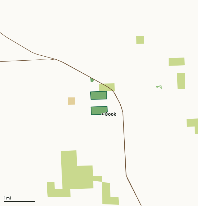
State wildlife management areasState forest and other DNR landNational forestOther federal landOwens WMACounty lineHighway
| Size | 164 acres in 2 pieces |
|---|---|
| County | St. Louis County |
| Deer Permit Area | DPA 177 |
| DNR lists for hunting | deer, ducks and geese, ruffed grouse and other forest upland birds, bear and small game |
| Nearest town (DNR) | Cook |
| DNR area office | Tower |
| Special restrictions | Yes, see the rules below |
| Nearest towns | Orr (16 mi), Tower (19 mi) and Mountain Iron (21 mi) |
What is Owens WMA like?
This WMA is managed primarily for brushland wildlife species and waterfowl. The WMA contains a mix of upland and lowland brush with scattered small ponds on the unit. The northeast 1/4 of the unit is primarily forested with aspen and lowland conifers.
There is a snowmobile trail that runs through the WMA along County Road 912. This WMA contains a short trail on the north side of the unit that is accessed from Highway 53 to River Street. Proceed south on River Street to where the street dead ends and the trail begins.
In the DNR's words, from its wildlife management area data.
What can you hunt on Owens WMA?
The DNR's WMA data lists deer, ducks and geese, ruffed grouse and other forest upland birds, bear and small game for Owens WMA. Each follows the statewide season and, for deer, the bag limit of the permit area.
What are the rules on Owens WMA?
Open to hunting and trapping in the regular seasons under the DNR's statewide WMA rules.
Special restriction the DNR lists for Owens WMA: This WMA is within the city limits of Cook, however hunting is allowed on this unit. Hunters need to be aware of where they are on this unit due to the proximity of homes on the north side of this WMA.
How many deer are taken around Owens WMA?
Owens WMA lies in Deer Permit Area 177. The DNR registered 510 deer in DPA 177 in 2025, against 481 in 2024.
| DPA | Owens WMA acres in it | Deer, 2025 | Deer, 2024 | Deer, 2023 |
|---|---|---|---|---|
| DPA 177 | 164 | 510 | 481 | 563 |
Harvest for the whole deer permit area, not the WMA alone: Minnesota DNR Deer Harvest Reports (2021 to 2025, 2025 report).
How do you get to Owens WMA?
Proceed to the north side of Cook on Hwy 53 to County Road 25. Turn south or left on County Road 25 approximately 1/3 of a mile to County Road 912. Continue south on County Road 912 another 1/4 of a mile and the WMA will be on your left.
This WMA provides limited disabled accessible sites from County Road 912 and River Street. Wet conditions are present and limit mobility in this area.
Nearest towns: Orr (16 miles), Tower (19 miles), Mountain Iron (21 miles) and Soudan (21 miles). Highways within 5 miles: MN 1 and US 53.
What other public land is near Owens WMA?
Public land within 3 miles of Owens WMA
Counting Owens WMA itself, 1,577 of the 23,149 acres within 3 miles of its boundary are public land open to the public (6.8%), by USGS PAD-US 4.1 (fee land open to the public).
| Manager | Acres within 3 miles |
|---|---|
| State forest and other DNR land | 1,364 |
| State wildlife management areas | 171 |
| Other federal land | 34 |
| National forest | 8 |
Questions hunters ask
Where is Owens WMA?
In St. Louis County, near Cook. The DNR's directions: Proceed to the north side of Cook on Hwy 53 to County Road 25. Turn south or left on County Road 25 approximately 1/3 of a mile to County Road 912. Continue south on County Road 912 another 1/4 of a mile and the WMA will be on your left.
Which deer permit area is Owens WMA in?
Deer Permit Area 177. Its bag limit and firearms dates apply.
How much public land is around Owens WMA?
1,577 acres within 3 miles of its boundary, Owens WMA included, by PAD-US 4.1.
Get a Minnesota hunt plan when they open
Hunt plans for Minnesota are coming. Join the list and you'll hear first. The first 50 hunters in each new state get their plan free.
Until then, the free FilledTag app for iPhone has a map that works in every state, Minnesota included.
Where these facts come from
- Area description, species, rules and directions: DNR, Owens WMA; Minnesota DNR Wildlife Management Area boundaries, publicly accessible.
- Boundary and acres: the DNR's map layer above. Surrounding public land: USGS PAD-US 4.1 (fee land open to the public).
- Deer harvest: Minnesota DNR Deer Harvest Reports (2021 to 2025, 2025 report).
FilledTag is not part of the Minnesota Department of Natural Resources. Check the DNR's rules and posted signs before you go.