Prairie Creek Wildlife Management Area: hunting and access
Prairie Creek Wildlife Management Area is 762 acres of state land managed by the Minnesota DNR in Rice County, near Nerstrand, inside Deer Permit Area 605. The DNR's WMA data lists deer, wild turkey, pheasants, ruffed grouse and other forest upland birds, mourning doves and small game for it. Hunters registered 3,115 deer in DPA 605 in 2025.
Data updated October 2026. Area facts: the DNR's wildlife management area data, read 2026-10. Harvest: DNR Deer Harvest Reports, 2021 to 2025.
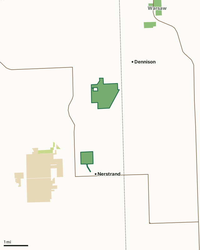
State wildlife management areasState forest and other DNR landState parksCounty, city and regional landPrairie Creek WMACounty lineHighway
| Size | 762 acres in 2 pieces |
|---|---|
| County | Rice County |
| Deer Permit Area | DPA 605 |
| DNR lists for hunting | deer, wild turkey, pheasants, ruffed grouse and other forest upland birds, mourning doves and small game |
| Nearest town (DNR) | Nerstrand |
| DNR area office | Owatonna |
| Special restrictions | Yes, see the rules below |
| Nearest towns | Nerstrand (next to it), Dennison (next to it) and Kenyon (6 mi) |
What is Prairie Creek WMA like?
The Engeseth-Rinde sub-unit conserves habitat for farmland wildlife dependent on woodland and grassland habitats. The unit has rolling topography and is bisected by a section of abandoned rail grade that was built in the 1880s connecting Dennison and Nerstrand. A variety of woodland habitats including open oak woodlands, a hardwood plantation and conifers provide shelter for wildlife. The Koester Prairie sub-unit conserves habitat for farmland wildlife dependent on prairie habitats. Steep rolling topography and prairie grassland and with rock outcrops dominates this unit.
This tract located on the edge of the Nerstrand Woods-Prairie Creek ecosystem where historically the woods met the open prairies to the east. This is a relatively new addition to the Wildlife Management Area system made possible through the Reinvest in Minnesota Critical Habitat Matching Program. Presently, croplands are a major cover type. Prairie grassland and savanna habitats are being expanded as crop fields are retired. Grants from Northfield Shares are helping to restore prairie and other natural habitats. The grasslands blend into hardwood forests on the western portion of the wildlife area. Prairie Creek is managed using a working lands approach including prescribed burning, haying and mowing and grazing to restore prairies and maintain grassland and oak savanna habitats.
In the DNR's words, from its wildlife management area data.
What can you hunt on Prairie Creek WMA?
The DNR's WMA data lists deer, wild turkey, pheasants, ruffed grouse and other forest upland birds, mourning doves and small game for Prairie Creek WMA. Each follows the statewide season and, for deer, the bag limit of the permit area.
What are the rules on Prairie Creek WMA?
Open to hunting and trapping in the regular seasons under the DNR's statewide WMA rules.
Special restriction the DNR lists for Prairie Creek WMA: There is no hunting along the access trail between the town of Nerstrand and the main body of the wildlife area.
How many deer are taken around Prairie Creek WMA?
Prairie Creek WMA lies in Deer Permit Area 605. The DNR registered 3,115 deer in DPA 605 in 2025, against 2,826 in 2024.
| DPA | Prairie Creek WMA acres in it | Deer, 2025 | Deer, 2024 | Deer, 2023 |
|---|---|---|---|---|
| DPA 605 | 762 | 3,115 | 2,826 | 2,821 |
Harvest for the whole deer permit area, not the WMA alone: Minnesota DNR Deer Harvest Reports (2021 to 2025, 2025 report).
How do you get to Prairie Creek WMA?
The wildlife area is on the north side of town. From Dennison, go 1 mile W on CSAH 31 then 1 mile S on Lamb Avenue to 13371 Lamb Avenue.
A grass/gravel surface parking area is provided along the west side of Kielmeyer Avenue in the southeast corner of the wildlife area. A 0.4 mile long foot path following the old rail grade provides access from Cherry Street in Nerstrand. No off-street parking is available at this location. An off road parking area is available on the east side of Lamb Avenue along the north boundary of the wildlife area. Stay off private drives and take care not to block shared field accesses.
Nearest towns: Nerstrand (next to it), Dennison (next to it), Kenyon (6 miles) and Northfield (7 miles). Highways within 5 miles: MN 246, MN 56 and MN 60.
What other public land is near Prairie Creek WMA?
DNR WMAs within 10 miles:
- Warsaw WMA: 244 acres, 2.5 miles away
- Cannon River Trout Lily WMA: 129 acres, 8.1 miles away
Public land within 3 miles of Prairie Creek WMA
Counting Prairie Creek WMA itself, 2,546 of the 36,692 acres within 3 miles of its boundary are public land open to the public (6.9%), by USGS PAD-US 4.1 (fee land open to the public).
| Manager | Acres within 3 miles |
|---|---|
| State parks | 1,630 |
| State wildlife management areas | 837 |
| State forest and other DNR land | 79 |
Questions hunters ask
Where is Prairie Creek WMA?
In Rice County, near Nerstrand. The DNR's directions: The wildlife area is on the north side of town. From Dennison, go 1 mile W on CSAH 31 then 1 mile S on Lamb Avenue to 13371 Lamb Avenue.
Which deer permit area is Prairie Creek WMA in?
Deer Permit Area 605. Its bag limit and firearms dates apply.
How much public land is around Prairie Creek WMA?
2,546 acres within 3 miles of its boundary, Prairie Creek WMA included, by PAD-US 4.1. 2 other WMAs are within 10 miles, the closest Warsaw WMA (2.5 miles).
Get a Minnesota hunt plan when they open
Hunt plans for Minnesota are coming. Join the list and you'll hear first. The first 50 hunters in each new state get their plan free.
Until then, the free FilledTag app for iPhone has a map that works in every state, Minnesota included.
Where these facts come from
- Area description, species, rules and directions: DNR, Prairie Creek WMA; Minnesota DNR Wildlife Management Area boundaries, publicly accessible.
- Boundary and acres: the DNR's map layer above. Surrounding public land: USGS PAD-US 4.1 (fee land open to the public).
- Deer harvest: Minnesota DNR Deer Harvest Reports (2021 to 2025, 2025 report).
FilledTag is not part of the Minnesota Department of Natural Resources. Check the DNR's rules and posted signs before you go.