Ramsey Mill Pond Wildlife Management Area: hunting and access
Ramsey Mill Pond Wildlife Management Area is 395 acres of state land managed by the Minnesota DNR in Mower County, near Lansing, inside Deer Permit Area 255. The DNR's WMA data lists deer, wild turkey, pheasants, ducks and geese, ruffed grouse and other forest upland birds, mourning doves and small game for it. Hunters registered 704 deer in DPA 255 in 2025.
Data updated October 2026. Area facts: the DNR's wildlife management area data, read 2026-10. Harvest: DNR Deer Harvest Reports, 2021 to 2025.
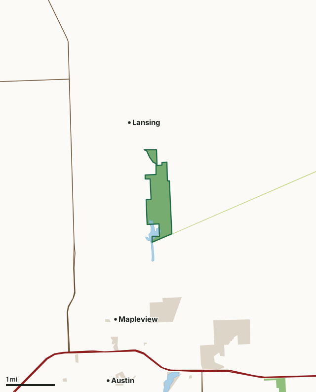
State wildlife management areasState forest and other DNR landCounty, city and regional landRamsey Mill Pond WMACounty lineLakeHighway
| Size | 395 acres |
|---|---|
| County | Mower County |
| Deer Permit Area | DPA 255 |
| DNR lists for hunting | deer, wild turkey, pheasants, ducks and geese, ruffed grouse and other forest upland birds, mourning doves and small game |
| Nearest town (DNR) | Lansing |
| DNR area office | Owatonna |
| Nearest towns | Lansing (next to it), Mapleview (2 mi) and Austin (3 mi) |
What is Ramsey Mill Pond WMA like?
This WMA is a mix of wetlands, woodlands, grasslands and river habitats. The area is managed by prescribed burns, mowing and selective cutting. The diversity of habitats is home to many species of fish and wildlife. The Cedar River State Water Trail passes through the WMA and the Wild Indigo Scientific and Natural Area and Trail bounds the southern end of the WMA.
The area is adjacent to the Red Cedar River providing walk in access to over 3 miles of river and portions of Ramsey Mill Pond. There are no developed boat accesses on the WMA. A walking trail leads from the east parking area to the river. Check out the Cedar River State Water Trail for more information about the river and the best locations for canoe and boat access. Ramsey Mill Pond WMA provides a variety of fish and wildlife-based recreational opportunities year round. Bird-watching is probably best during spring migration as waterfowl and songbirds concentrate along the river and riparian areas. Woodcock and snipe grace the evening skies with aerial displays and the bugle of sandhill cranes echoes through the river bottoms. Most sought after game species include deer, wild turkey, pheasants, other small game and furbearers.
In the DNR's words, from its wildlife management area data.
What can you hunt on Ramsey Mill Pond WMA?
The DNR's WMA data lists deer, wild turkey, pheasants, ducks and geese, ruffed grouse and other forest upland birds, mourning doves and small game for Ramsey Mill Pond WMA. Each follows the statewide season and, for deer, the bag limit of the permit area.
What are the rules on Ramsey Mill Pond WMA?
Open to hunting and trapping in the regular seasons under the DNR's statewide WMA rules.
How many deer are taken around Ramsey Mill Pond WMA?
Ramsey Mill Pond WMA lies in Deer Permit Area 255. The DNR registered 704 deer in DPA 255 in 2025, against 677 in 2024.
| DPA | Ramsey Mill Pond WMA acres in it | Deer, 2025 | Deer, 2024 | Deer, 2023 |
|---|---|---|---|---|
| DPA 255 | 395 | 704 | 677 | 677 |
Harvest for the whole deer permit area, not the WMA alone: Minnesota DNR Deer Harvest Reports (2021 to 2025, 2025 report).
How do you get to Ramsey Mill Pond WMA?
From Lansing, go 1.5 miles east on CSAH 2, then 1.5 miles south on County Highway 61, then 1/2 mile west along a trail to a gravel parking lot to access the main body of the WMA. To access the west side of the WMA from Lansing, go south 1 mile along CSAH 25 to 260th Street, then 1/2 mile east to a field access and parking area. The north side of the WMA is accessed by traveling 1/2 mile south on a township cartway that is 3/4 miles east of Lansing off of CSAH 2.
Small parking areas are located at the end of the east access trail and off of 260th Street on the west side of the WMA.
Nearest towns: Lansing (next to it), Mapleview (2 miles), Austin (3 miles) and Brownsdale (4 miles). Highways within 5 miles: US 218, I-90, MN 56, MN 105 and MN 251.
What other public land is near Ramsey Mill Pond WMA?
DNR WMAs within 10 miles:
- Mentel WMA: 37 acres, 3.5 miles away
- Lyle-austin WMA: 115 acres, 4.2 miles away
- Schrafel WMA: 33 acres, 4.4 miles away
- Carex WMA: 332 acres, 5.9 miles away
- Schottler WMA: 166 acres, 7.8 miles away
- Wo Wacintanka WMA: 558 acres, 8.3 miles away
Public land within 3 miles of Ramsey Mill Pond WMA
Counting Ramsey Mill Pond WMA itself, 1,053 of the 27,024 acres within 3 miles of its boundary are public land open to the public (3.9%), by USGS PAD-US 4.1 (fee land open to the public).
| Manager | Acres within 3 miles |
|---|---|
| County, city and regional land | 627 |
| State wildlife management areas | 396 |
| State forest and other DNR land | 30 |
Questions hunters ask
Where is Ramsey Mill Pond WMA?
In Mower County, near Lansing. The DNR's directions: From Lansing, go 1.5 miles east on CSAH 2, then 1.5 miles south on County Highway 61, then 1/2 mile west along a trail to a gravel parking lot to access the main body of the WMA. To access the west side of the WMA from Lansing, go south 1 mile along CSAH 25 to 260th Street, then 1/2 mile east to a field access and parking area. The north side of the WMA is accessed by traveling 1/2 mile south on a township cartway that is 3/4 miles east of Lansing off of CSAH 2.
Which deer permit area is Ramsey Mill Pond WMA in?
Deer Permit Area 255. Its bag limit and firearms dates apply.
How much public land is around Ramsey Mill Pond WMA?
1,053 acres within 3 miles of its boundary, Ramsey Mill Pond WMA included, by PAD-US 4.1. 6 other WMAs are within 10 miles, the closest Mentel WMA (3.5 miles).
Get a Minnesota hunt plan when they open
Hunt plans for Minnesota are coming. Join the list and you'll hear first. The first 50 hunters in each new state get their plan free.
Until then, the free FilledTag app for iPhone has a map that works in every state, Minnesota included.
Where these facts come from
- Area description, species, rules and directions: DNR, Ramsey Mill Pond WMA; Minnesota DNR Wildlife Management Area boundaries, publicly accessible.
- Boundary and acres: the DNR's map layer above. Surrounding public land: USGS PAD-US 4.1 (fee land open to the public).
- Deer harvest: Minnesota DNR Deer Harvest Reports (2021 to 2025, 2025 report).
FilledTag is not part of the Minnesota Department of Natural Resources. Check the DNR's rules and posted signs before you go.