Rau Prairie Pothole Wildlife Management Area: hunting and access
Rau Prairie Pothole Wildlife Management Area is 191 acres of state land managed by the Minnesota DNR in Kandiyohi County, near Willmar, inside Deer Permit Area 277. The DNR's WMA data lists deer, wild turkey, pheasants, ducks and geese, mourning doves and small game for it. Hunters registered 4,575 deer in DPA 277 in 2025.
Data updated October 2026. Area facts: the DNR's wildlife management area data, read 2026-10. Harvest: DNR Deer Harvest Reports, 2021 to 2025.
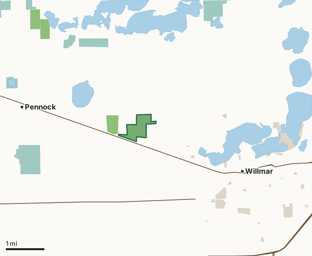
State wildlife management areasState forest and other DNR landNational wildlife refuges and waterfowl production areasCounty, city and regional landRau Prairie Pothole WMACounty lineLakeHighway
| Size | 191 acres |
|---|---|
| County | Kandiyohi County |
| Deer Permit Area | DPA 277 |
| DNR lists for hunting | deer, wild turkey, pheasants, ducks and geese, mourning doves and small game |
| Nearest town (DNR) | Willmar |
| DNR area office | New London |
| Special restrictions | Yes, see the rules below |
| Nearest towns | Willmar (3 mi), Pennock (3 mi) and Kandiyohi (8 mi) |
What is Rau Prairie Pothole WMA like?
This 100+ acre unit was developed with native grass/forb nesting cover fields, several wetland restorations, and woody winter cover development in the SE corner. This former Walk-in-Access area has now been purchased as a WMA to allow permanent access for hunters and to provide the DNR the ability to manage this habitat for wildlife.
Management efforts have focused on wetland quality. We have completed several cattail reduction projects. Beaver population management is an ongoing, continuous endeavor. The uplands were restored to a high diversity native grasses and forbs mixture. Willow reduction is also a goal. Primary management tools are prescribed fire and mechanical projects for tree and cattail reduction. This tract is a 92.4 acre addition comprised of uplands restored to native prairie species, and wetlands with abundant cattails and abundant willow species surrounding them. It is excellent nesting and winter cover for ringneck pheasants. The unit was burned in 2025 and will be managed with prescribed fire going forward. Turkeys have arrived in the area, but this is primarily a deer and pheasant hunting unit. There are waterfowl hunting opportunities on the other (original) tract of Rau Prairie Potholes WMA.
In the DNR's words, from its wildlife management area data.
What can you hunt on Rau Prairie Pothole WMA?
The DNR's WMA data lists deer, wild turkey, pheasants, ducks and geese, mourning doves and small game for Rau Prairie Pothole WMA. Each follows the statewide season and, for deer, the bag limit of the permit area.
What are the rules on Rau Prairie Pothole WMA?
Open to hunting and trapping in the regular seasons under the DNR's statewide WMA rules.
Special restriction the DNR lists for Rau Prairie Pothole WMA: Use caution and restraint while hunting on the east end of the unit. There are several residential homes on this side of the WMA.
How many deer are taken around Rau Prairie Pothole WMA?
Rau Prairie Pothole WMA lies in Deer Permit Area 277. The DNR registered 4,575 deer in DPA 277 in 2025, against 4,301 in 2024.
| DPA | Rau Prairie Pothole WMA acres in it | Deer, 2025 | Deer, 2024 | Deer, 2023 |
|---|---|---|---|---|
| DPA 277 | 191 | 4,575 | 4,301 | 4,013 |
Harvest for the whole deer permit area, not the WMA alone: Minnesota DNR Deer Harvest Reports (2021 to 2025, 2025 report).
How do you get to Rau Prairie Pothole WMA?
From the junction of CR #5 and US #12 on the west edge of Willmar, travel west on US #12 a distance of 2.57 miles and then turn north on township gravel (60th St. NW). Go over the RR tracks, and access to the unit will be on your right (east) side. From the intersection of County Road 5 and 15th Ave. NW, just west of Ridgewater College, head west of 15th Ave. NW for 1 mile directly into the parking area.
There is road adjacent to the southwest boundary of the unit. A parking lot was established in this location. There is also an access point on the east side of the new acquisition off 45th St. SW. A parking lot will be constructed there soon. Access is from an approach and future parking lot immediately west of the "T" where 15th Ave. NW meets 45th St. NW.
Nearest towns: Willmar (3 miles), Pennock (3 miles), Kandiyohi (8 miles) and Raymond (10 miles). Highways within 5 miles: MN 23, US 71, US 12 and MN 40.
What other public land is near Rau Prairie Pothole WMA?
DNR WMAs within 10 miles:
- Gopher Ridge WMA: 90 acres, next to it
- RIM Memorial WMA: 77 acres, 3 miles away
- Mamre WMA: 80 acres, 3.3 miles away
- Willmar WMA: 127 acres, 4.4 miles away
- Eagle WMA: 50 acres, 5.5 miles away
- Reed WMA: 118 acres, 6.1 miles away
Public land within 3 miles of Rau Prairie Pothole WMA
Counting Rau Prairie Pothole WMA itself, 880 of the 23,311 acres within 3 miles of its boundary are public land open to the public (3.8%), by USGS PAD-US 4.1 (fee land open to the public).
| Manager | Acres within 3 miles |
|---|---|
| National wildlife refuges and waterfowl production areas | 479 |
| State wildlife management areas | 288 |
| County, city and regional land | 107 |
| State forest and other DNR land | 6 |
Questions hunters ask
Where is Rau Prairie Pothole WMA?
In Kandiyohi County, near Willmar. The DNR's directions: From the junction of CR #5 and US #12 on the west edge of Willmar, travel west on US #12 a distance of 2.57 miles and then turn north on township gravel (60th St. NW). Go over the RR tracks, and access to the unit will be on your right (east) side. From the intersection of County Road 5 and 15th Ave. NW, just west of Ridgewater College, head west of 15th Ave. NW for 1 mile directly into the parking area.
Which deer permit area is Rau Prairie Pothole WMA in?
Deer Permit Area 277. Its bag limit and firearms dates apply.
How much public land is around Rau Prairie Pothole WMA?
880 acres within 3 miles of its boundary, Rau Prairie Pothole WMA included, by PAD-US 4.1. 6 other WMAs are within 10 miles, the closest Gopher Ridge WMA (next to it).
Get a Minnesota hunt plan when they open
Hunt plans for Minnesota are coming. Join the list and you'll hear first. The first 50 hunters in each new state get their plan free.
Until then, the free FilledTag app for iPhone has a map that works in every state, Minnesota included.
Where these facts come from
- Area description, species, rules and directions: DNR, Rau Prairie Pothole WMA; Minnesota DNR Wildlife Management Area boundaries, publicly accessible.
- Boundary and acres: the DNR's map layer above. Surrounding public land: USGS PAD-US 4.1 (fee land open to the public).
- Deer harvest: Minnesota DNR Deer Harvest Reports (2021 to 2025, 2025 report).
FilledTag is not part of the Minnesota Department of Natural Resources. Check the DNR's rules and posted signs before you go.