Swan Lake Wildlife Management Area: hunting and access
Swan Lake Wildlife Management Area is 3,396 acres of state land managed by the Minnesota DNR in Nicollet and Le Sueur counties, near Nicollet, inside Deer Permit Area 291. The DNR's WMA data lists deer, wild turkey, pheasants, ducks and geese, ruffed grouse and other forest upland birds, mourning doves and small game for it. Hunters registered 1,896 deer in DPA 291 in 2025.
Data updated October 2026. Area facts: the DNR's wildlife management area data, read 2026-10. Harvest: DNR Deer Harvest Reports, 2021 to 2025.
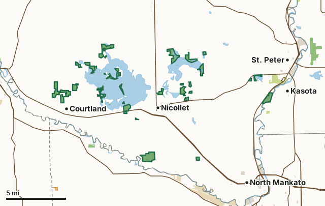
State wildlife management areasState forest and other DNR landState parksCounty, city and regional landWalk-In AccessSwan Lake WMACounty lineLakeHighway
| Size | 3,396 acres in 37 pieces |
|---|---|
| Counties | Nicollet County and Le Sueur County |
| Deer Permit Area | DPA 291 |
| DNR lists for hunting | deer, wild turkey, pheasants, ducks and geese, ruffed grouse and other forest upland birds, mourning doves and small game |
| Nearest town (DNR) | Nicollet |
| DNR area office | Nicollet |
| Special restrictions | Yes, see the rules below |
| Nearest towns | Courtland (next to it), Nicollet (next to it) and Kasota (next to it) |
What is Swan Lake WMA like?
The Peterson Lake Unit is mainly comprised of: A restored prairie wetland complex with an upland forest component with an agricultural food plot. The Duck Lake Unit WMA is mainly comprised of: A restored prairie wetland complex with an upland forest component. The Courtland West Unit WMA is mainly comprised of: A restored prairie wetland complex with an Agricultural food plot. The Courtland Bay Unit WMA is mainly comprised of: A restored prairie wetland complex with an upland forest component. The Johnson Marsh Unit WMA is mainly comprised of: A restored prairie wetland complex. The Tri Island Unit WMA is mainly comprised of: Upland, lowland and wetland forest types. The Courtland East Unit WMA is mainly comprised of: A restored prairie wetland complex. The Hackberry Point Unit WMA is mainly comprised of: A restored prairie wetland complex with a forested wetland component and an agricultural food plot. The Oak Leaf Unit WMA is mainly comprised of: A restored prairie wetland complex, and shallow lake. The Wiwi Bay Unit WMA is mainly comprised of: A restored prairie wetland complex with a lowland brush-land component. The Mackenzie Tract consists of 2 separate units of restored native prairie with a restored wetland on the north tract. The Oshawa Unit WMA is mainly comprised of: A restored prairie wetland complex with a forested wetland component and an agricultural food plot. The Little Lake Unit WMA is mainly comprised of: A restored prairie wetland complex with upland and lowland forest types. The Peterson Lake Unit WMA is mainly comprised of: A restored prairie wetland complex with an upland forest component with an agricultural food plot. The Nicollet Bay Unit WMA is mainly comprised of: A restored prairie wetland complex with upland and lowland forest types with an agricultural food plot. The Courtland Central Unit WMA is mainly comprised of: A restored prairie wetland complex and wetland forest component. The Nicollet Bay Unit is mainly comprised of: A restored prairie wetland complex with an agricultural food plot and large shallow lake. The Larson Unit WMA is mainly comprised of: A bottomland forest with a restored oak savanna component. The Peterson Lake East Unit is comprised of a 13-acre hardwood forest. The Middle Lake Unit WMA is mainly comprised of: A restored prairie wetland complex. The Northeast Angle Unit is mainly comprised of: A restored prairie wetland complex. The Nicollet Creek Unit is mainly comprised of: A restored prairie complex. The North Star Unit is mainly comprised of: A restored oak savanna complex with upland and lowland forest types and several created ponds.
A primitive boat launch is available to the Western portion of Swan Lake. This unit is very attractive to many nongame species, too. A prairie flower planting in the northwest corner of the unit attracts grassland birds and butterflies. This subunit is accessible by water only. This area is also know as Dallmann Island. Two of the Little Lake Tracts are only accessible via permission from adjacent private landowners or water. The Nicollet Creek Unit is only accessible via permission from adjacent landowners. No public access.
In the DNR's words, from its wildlife management area data.
What can you hunt on Swan Lake WMA?
The DNR's WMA data lists deer, wild turkey, pheasants, ducks and geese, ruffed grouse and other forest upland birds, mourning doves and small game for Swan Lake WMA. Each follows the statewide season and, for deer, the bag limit of the permit area.
What are the rules on Swan Lake WMA?
Open to hunting and trapping in the regular seasons under the DNR's statewide WMA rules.
Special restriction the DNR lists for Swan Lake WMA: Duck Lake has a Restricted hunting area posted on the Northwest side of the unit.
Special restriction the DNR lists for Swan Lake WMA: This subunit is accessible by water only.
Special restriction the DNR lists for Swan Lake WMA: Water access only.
Special restriction the DNR lists for Swan Lake WMA: This WMA is within the Swan Lake Waterfowl & State Game Refuge. Please consult the Minnesota hunting regulations for restrictions on this WMA.
Special restriction the DNR lists for Swan Lake WMA: No motors are allowed during the open waterfowl season.
Special restriction the DNR lists for Swan Lake WMA: Visitors should be aware that the public Township road 515th Lane becomes a private road south of the WMA parking lot.
Special restriction the DNR lists for Swan Lake WMA: This WMA is within the Swan Lake Waterfowl & State Game Refuge. Please consult the Minnesota hunting regulations for restrictions on this WMA or contact the Area Wildlife office.
Special restriction the DNR lists for Swan Lake WMA: Land access to the peninsula is private. Public and private holdings are mixed on the peninsula, so WMA users must be aware of land boundaries. There is no public access to this unit except by water.
Special restriction the DNR lists for Swan Lake WMA: A restricted shooting area is located around the MN DNR buildings on site.
How many deer are taken around Swan Lake WMA?
Swan Lake WMA lies in Deer Permit Area 291. The DNR registered 1,896 deer in DPA 291 in 2025, against 1,513 in 2024.
| DPA | Swan Lake WMA acres in it | Deer, 2025 | Deer, 2024 | Deer, 2023 |
|---|---|---|---|---|
| DPA 291 | 3,396 | 1,896 | 1,513 | 1,504 |
Harvest for the whole deer permit area, not the WMA alone: Minnesota DNR Deer Harvest Reports (2021 to 2025, 2025 report).
How do you get to Swan Lake WMA?
From Nicollet, go 4.5 miles N on ST HWY 111 and 4 miles W on CSAH 5. From Nicollet, go 4 1/2 miles N on ST HWY 111, 1 mile W on CO RD 5. From Courtland, go 3/4 miles N on CSAH 12. From Nicollet, go 4.5 miles W on US HWY 14, 3.5 miles N on CSAH 11, and 1 mile N on a township road. From Nicollet, go 4 1/2 miles SE on US HWY 14. From Nicollet, go 4 1/4 miles SE on US 14. From Nicollet, go 4.5 miles W on US HWY 14, 3 miles N on CO RD 11, and 0.25 miles W on a township road. From Nicollet, go 4.5 miles W on U.S 14, then 1.5 miles N on County Road 11. From St. Peter, go 1.25 miles W on ST HWY 99. From St. Peter, go 7.75 miles W on CSAH 5. From Nicollet, go 2 miles W on U.S. Highway 14. From Nicollet travel North on Hwy 111 for 4.7 miles to CASH 5 (Fort Road). Turn west on CSAH 5 and travel for 5 miles to 515th Lane. Turn south on 515th Lane and travel for 1.5 miles to WMA. From Nicollet, go 4 1/4 miles SE on US HWY 14. From St. Peter, go 4.5 miles W on ST HWY 99, 2 miles NW on CO RD 13, and 0.5 miles W on a township road. From Nicollet, go 1/2 mile E on SH 99, then 1/3 mile N and 1 mile E and 1/2 mile N on Twp Rd. From Nicollet, go 4.5 miles N on County Road 111 and 4 miles W on County Road 5. From Nicollet, go 2 miles W on U.S. Highway 14. This portion of the WMA lies on the South side of the highway. From Courtland, go 3/4 miles N on County Road 12. From Nicollet, go 4.5 miles W on US HWY 14, then 1.5 miles N on CO RD 11. From Nicollet, go 2 miles W on US HWY 14. From St. Peter, go 2 miles S of St. Peter on US HWY 169. From Nicollet travel north on Hwy 111 for 4.7 miles to CSAH 5 (Fort Road). Turn west on CSAH 5 and travel for 4.5 miles. Turn south at gravel driveway and travel 0.4 miles to parking lot. Walk southeast from parking lot for 1/4 mile to Swan Lake shoreline and cross to island. From Nicollet, go 1.5 miles N on MN 111 to the WMA on the right-hand side of the road. From St. Peter, go 6.5 miles W on CSAH 5 and 0.25 miles S on CSAH 13. From Nicollet, go 4 miles S on CSAH 23, and 0.5 miles W on CO RD 62.
Wheelchair access is limited to three gravel parking lots and adjacent county and township roads. A primitive trail leads from the southern parking to a corn food plot. Wheelchair access is limited to two gravel parking lots. Wheelchair access is available at two gravel parking lots, one on either side of CSAH 12. At the southern parking lot, a primitive trail leads back into the unit. Wheelchair access is available at the gravel parking lot, access road, and adjacent township road. This unit is not accessible to wheelchairs. Wheelchair access is limited to the gravel parking lot. Wheelchair access is limited to gravel parking lot at north end of unit and adjacent township road. Wheelchair access is limited to three gravel parking lots and adjacent county and township roads. Wheelchair access along roads through the unit requires permission from adjacent landowner. A public water access is available on this unit to the Southern portion of Swan Lake and Nicollet Bay. Wheelchair access is limited to small gravel parking area and primitive trail running from parking area to the Minnesota River. Access to this unit is either by wading from the adjacent uplands or via boat. Wheelchair access is limited to the adjacent county road.
Nearest towns: Courtland (next to it), Nicollet (next to it), Kasota (next to it) and St. Peter (2 miles). Highways within 5 miles: US 14, US 169, MN 68, MN 22 and MN 99.
What other public land is near Swan Lake WMA?
DNR WMAs within 10 miles:
- Cambria WMA: 82 acres, 3.5 miles away
- Ottawa WMA: 674 acres, 3.9 miles away
- Fritsche Creek WMA: 386 acres, 4.8 miles away
- Picnic Rock WMA: 181 acres, 4.9 miles away
- O A Vee Memorial WMA: 253 acres, 5.1 miles away
- Bur Oak WMA: 212 acres, 6.2 miles away
Public land within 3 miles of Swan Lake WMA
Counting Swan Lake WMA itself, 4,907 of the 167,391 acres within 3 miles of its boundary are public land open to the public (2.9%), by USGS PAD-US 4.1 (fee land open to the public).
| Manager | Acres within 3 miles |
|---|---|
| State wildlife management areas | 3,469 |
| State parks | 718 |
| State forest and other DNR land | 482 |
| County, city and regional land | 238 |
Questions hunters ask
Where is Swan Lake WMA?
In Nicollet and Le Sueur counties, near Nicollet. The DNR's directions: From Nicollet, go 4.5 miles N on ST HWY 111 and 4 miles W on CSAH 5. From Nicollet, go 4 1/2 miles N on ST HWY 111, 1 mile W on CO RD 5. From Courtland, go 3/4 miles N on CSAH 12. From Nicollet, go 4.5 miles W on US HWY 14, 3.5 miles N on CSAH 11, and 1 mile N on a township road. From Nicollet, go 4 1/2 miles SE on US HWY 14. From Nicollet, go 4 1/4 miles SE on US 14. From Nicollet, go 4.5 miles W on US HWY 14, 3 miles N on CO RD 11, and 0.25 miles W on a township road. From Nicollet, go 4.5 miles W on U.S 14, then 1.5 miles N on County Road 11. From St. Peter, go 1.25 miles W on ST HWY 99. From St. Peter, go 7.75 miles W on CSAH 5. From Nicollet, go 2 miles W on U.S. Highway 14. From Nicollet travel North on Hwy 111 for 4.7 miles to CASH 5 (Fort Road). Turn west on CSAH 5 and travel for 5 miles to 515th Lane. Turn south on 515th Lane and travel for 1.5 miles to WMA. From Nicollet, go 4 1/4 miles SE on US HWY 14. From St. Peter, go 4.5 miles W on ST HWY 99, 2 miles NW on CO RD 13, and 0.5 miles W on a township road. From Nicollet, go 1/2 mile E on SH 99, then 1/3 mile N and 1 mile E and 1/2 mile N on Twp Rd. From Nicollet, go 4.5 miles N on County Road 111 and 4 miles W on County Road 5. From Nicollet, go 2 miles W on U.S. Highway 14. This portion of the WMA lies on the South side of the highway. From Courtland, go 3/4 miles N on County Road 12. From Nicollet, go 4.5 miles W on US HWY 14, then 1.5 miles N on CO RD 11. From Nicollet, go 2 miles W on US HWY 14. From St. Peter, go 2 miles S of St. Peter on US HWY 169. From Nicollet travel north on Hwy 111 for 4.7 miles to CSAH 5 (Fort Road). Turn west on CSAH 5 and travel for 4.5 miles. Turn south at gravel driveway and travel 0.4 miles to parking lot. Walk southeast from parking lot for 1/4 mile to Swan Lake shoreline and cross to island. From Nicollet, go 1.5 miles N on MN 111 to the WMA on the right-hand side of the road. From St. Peter, go 6.5 miles W on CSAH 5 and 0.25 miles S on CSAH 13. From Nicollet, go 4 miles S on CSAH 23, and 0.5 miles W on CO RD 62.
Which deer permit area is Swan Lake WMA in?
Deer Permit Area 291. Its bag limit and firearms dates apply.
How much public land is around Swan Lake WMA?
4,907 acres within 3 miles of its boundary, Swan Lake WMA included, by PAD-US 4.1. 6 other WMAs are within 10 miles, the closest Cambria WMA (3.5 miles).
Get a Minnesota hunt plan when they open
Hunt plans for Minnesota are coming. Join the list and you'll hear first. The first 50 hunters in each new state get their plan free.
Until then, the free FilledTag app for iPhone has a map that works in every state, Minnesota included.
Where these facts come from
- Area description, species, rules and directions: DNR, Swan Lake WMA; Minnesota DNR Wildlife Management Area boundaries, publicly accessible.
- Boundary and acres: the DNR's map layer above. Surrounding public land: USGS PAD-US 4.1 (fee land open to the public).
- Deer harvest: Minnesota DNR Deer Harvest Reports (2021 to 2025, 2025 report).
FilledTag is not part of the Minnesota Department of Natural Resources. Check the DNR's rules and posted signs before you go.