Vermillion Highlands Research Recreation and Wildlife Management Area: hunting and access
Vermillion Highlands Research Recreation and Wildlife Management Area is 2,841 acres of state land managed by the Minnesota DNR in Dakota County, near Farmington, inside Deer Permit Area 605. The DNR's WMA data lists deer, wild turkey, pheasants and ducks and geese for it. Hunters registered 3,115 deer in DPA 605 in 2025.
Data updated October 2026. Area facts: the DNR's wildlife management area data, read 2026-10. Harvest: DNR Deer Harvest Reports, 2021 to 2025.
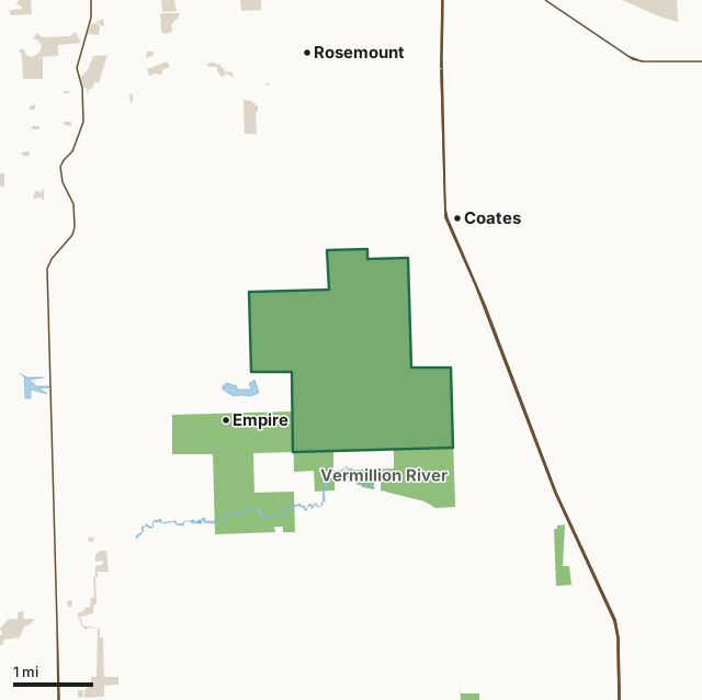
State wildlife management areasCounty, city and regional landVermillion Highlands Research Recreation and WMACounty lineLakeHighway
| Size | 2,841 acres |
|---|---|
| County | Dakota County |
| Deer Permit Area | DPA 605 |
| DNR lists for hunting | deer, wild turkey, pheasants and ducks and geese |
| Nearest town (DNR) | Farmington |
| DNR area office | South Metro |
| Special restrictions | Yes, see the rules below |
| Nearest towns | Empire (next to it), Coates (next to it) and Rosemount (2 mi) |
What is Vermillion Highlands Research Recreation and WMA like?
This WMA was created by the State Legislature and Gov Tim Pawlenty as part of the U of M stadium deal in 2006. The unit is managed by the DNR and the U of M to provide recreation opportunities for the public and research opportunities for the University.
Please do not block field access roads or gates when parking and obey No Trespassing signs and fenced areas. Please respect and do not interfere with agricultural operations. Portions of the WMA will be open for hunting of certain species throughout the year. Click the seasonal hunting information link on this page for details on upcoming hunting opportunities or call the Wildlife Area office at 651-322-4643.
In the DNR's words, from its wildlife management area data.
What can you hunt on Vermillion Highlands Research Recreation and WMA?
The DNR's WMA data lists deer, wild turkey, pheasants and ducks and geese for Vermillion Highlands Research Recreation and WMA. Each follows the statewide season and, for deer, the bag limit of the permit area.
What are the rules on Vermillion Highlands Research Recreation and WMA?
Open to hunting and trapping in the regular seasons under the DNR's statewide WMA rules.
Special restriction the DNR lists for Vermillion Highlands Research Recreation and WMA: Vermillion Highlands-A Research, Recreation and Wildlife Management Area (Dakota County) is open to archery, firearms and muzzleloader deer hunting by special lottery only and is open to late season goose hunting and spring turkey hunting. Pheasant and goose hunting is open from December 15th through December 21st, 2025. Predator hunting is allowed from January 1 to March 15 by special permit only. Dogs must be leashed at all times, except during late season Pheasant and Goose hunting. No bikes allowed. Contact the Vermillion Complex Wildlife Office for questions at 651-322-4643.
How many deer are taken around Vermillion Highlands Research Recreation and WMA?
Vermillion Highlands Research Recreation and WMA lies in Deer Permit Area 605. The DNR registered 3,115 deer in DPA 605 in 2025, against 2,826 in 2024.
| DPA | Vermillion Highlands Research Recreation and WMA acres in it | Deer, 2025 | Deer, 2024 | Deer, 2023 |
|---|---|---|---|---|
| DPA 605 | 2,841 | 3,115 | 2,826 | 2,821 |
Harvest for the whole deer permit area, not the WMA alone: Minnesota DNR Deer Harvest Reports (2021 to 2025, 2025 report).
How do you get to Vermillion Highlands Research Recreation and WMA?
From the junction of Highway 52 and County Highway 46, travel 4.2 miles west on County Highway 46, take a left (south) on Biscayne Avenue, then go 1 mile to 170th Street W, take a left (east) and travel 1.1 miles to Station Trail, take a right (southeast) on Station Trail, then go 0.7 miles to parking area/trail head on the right side of the road.
Nearest towns: Empire (next to it), Coates (next to it), Rosemount (2 miles) and Vermillion (4 miles). Highways within 5 miles: US 52, MN 56, MN 3 and MN 55.
What other public land is near Vermillion Highlands Research Recreation and WMA?
DNR WMAs within 10 miles:
- Vermillion River WMA: 1,494 acres, next to it
- Hampton Woods WMA: 208 acres, 3 miles away
- Spring Lake Islands WMA: 766 acres, 4.3 miles away
Public land within 3 miles of Vermillion Highlands Research Recreation and WMA
Counting Vermillion Highlands Research Recreation and WMA itself, 4,497 of the 38,149 acres within 3 miles of its boundary are public land open to the public (11.8%), by USGS PAD-US 4.1 (fee land open to the public).
| Manager | Acres within 3 miles |
|---|---|
| State wildlife management areas | 4,399 |
| County, city and regional land | 98 |
Questions hunters ask
Where is Vermillion Highlands Research Recreation and WMA?
In Dakota County, near Farmington. The DNR's directions: From the junction of Highway 52 and County Highway 46, travel 4.2 miles west on County Highway 46, take a left (south) on Biscayne Avenue, then go 1 mile to 170th Street W, take a left (east) and travel 1.1 miles to Station Trail, take a right (southeast) on Station Trail, then go 0.7 miles to parking area/trail head on the right side of the road.
Which deer permit area is Vermillion Highlands Research Recreation and WMA in?
Deer Permit Area 605. Its bag limit and firearms dates apply.
How much public land is around Vermillion Highlands Research Recreation and WMA?
4,497 acres within 3 miles of its boundary, Vermillion Highlands Research Recreation and WMA included, by PAD-US 4.1. 3 other WMAs are within 10 miles, the closest Vermillion River WMA (next to it).
Get a Minnesota hunt plan when they open
Hunt plans for Minnesota are coming. Join the list and you'll hear first. The first 50 hunters in each new state get their plan free.
Until then, the free FilledTag app for iPhone has a map that works in every state, Minnesota included.
Where these facts come from
- Area description, species, rules and directions: DNR, Vermillion Highlands Research Recreation and WMA; Minnesota DNR Wildlife Management Area boundaries, publicly accessible.
- Boundary and acres: the DNR's map layer above. Surrounding public land: USGS PAD-US 4.1 (fee land open to the public).
- Deer harvest: Minnesota DNR Deer Harvest Reports (2021 to 2025, 2025 report).
FilledTag is not part of the Minnesota Department of Natural Resources. Check the DNR's rules and posted signs before you go.