West Union Wildlife Management Area: hunting and access
West Union Wildlife Management Area is 243 acres of state land managed by the Minnesota DNR in Todd County, near Osakis, inside Deer Permit Area 213. The DNR's WMA data lists deer, pheasants, ducks and geese and small game for it. Hunters registered 6,423 deer in DPA 213 in 2025.
Data updated October 2026. Area facts: the DNR's wildlife management area data, read 2026-10. Harvest: DNR Deer Harvest Reports, 2021 to 2025.
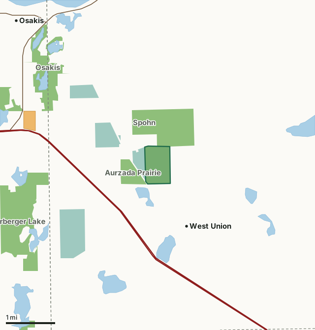
State wildlife management areasNational wildlife refuges and waterfowl production areasWalk-In AccessWest Union WMACounty lineLakeHighway
| Size | 243 acres |
|---|---|
| County | Todd County |
| Deer Permit Area | DPA 213 |
| DNR lists for hunting | deer, pheasants, ducks and geese and small game |
| Nearest town (DNR) | Osakis |
| DNR area office | Little Falls |
| Special restrictions | Yes, see the rules below |
| Nearest towns | West Union (next to it), Osakis (4 mi) and Westport (8 mi) |
What is West Union WMA like?
This WMA is a prairie/wetland complex with grass fields, restored native grass fields, wetlands, restored wetlands, cattails, lowland grass, and brush.
In the DNR's words, from its wildlife management area data.
What can you hunt on West Union WMA?
The DNR's WMA data lists deer, pheasants, ducks and geese and small game for West Union WMA. Each follows the statewide season and, for deer, the bag limit of the permit area.
What are the rules on West Union WMA?
Open to hunting and trapping in the regular seasons under the DNR's statewide WMA rules.
Special restriction the DNR lists for West Union WMA: Motorized vehicles are prohibited on the WMA except on designated routes and parking lots. Off-highway vehicles (OHVs), all-terrain vehicles (ATVs), and snowmobiles are prohibited anywhere on the WMA, including on designated parking lots and access road.
How many deer are taken around West Union WMA?
West Union WMA lies in Deer Permit Area 213. The DNR registered 6,423 deer in DPA 213 in 2025, against 5,814 in 2024.
| DPA | West Union WMA acres in it | Deer, 2025 | Deer, 2024 | Deer, 2023 |
|---|---|---|---|---|
| DPA 213 | 243 | 6,423 | 5,814 | 5,058 |
Harvest for the whole deer permit area, not the WMA alone: Minnesota DNR Deer Harvest Reports (2021 to 2025, 2025 report).
How do you get to West Union WMA?
From Osakis, go 2 miles south on county road 51, then 1 mile east on county road 2.
Disabled access is limited to the county road and parking lot on the NW side of the WMA.
Nearest towns: West Union (next to it), Osakis (4 miles), Westport (8 miles) and Sauk Centre (9 miles). Highways within 5 miles: US 52, I-94, MN 27 and MN 127. 1 Walk-In Access site within 3 miles.
What other public land is near West Union WMA?
DNR WMAs within 10 miles:
- Aurzada Prairie WMA: 105 acres, next to it
- Quistorff WMA: 359 acres, next to it
- Spohn WMA: 162 acres, next to it
- Herberger Lake WMA: 690 acres, 2 miles away
- Osakis WMA: 477 acres, 2 miles away
- Randall WMA: 58 acres, 3.4 miles away
Public land within 3 miles of West Union WMA
Counting West Union WMA itself, 2,458 of the 23,062 acres within 3 miles of its boundary are public land open to the public (10.7%), by USGS PAD-US 4.1 (fee land open to the public).
| Manager | Acres within 3 miles |
|---|---|
| State wildlife management areas | 1,852 |
| National wildlife refuges and waterfowl production areas | 606 |
Questions hunters ask
Where is West Union WMA?
In Todd County, near Osakis. The DNR's directions: From Osakis, go 2 miles south on county road 51, then 1 mile east on county road 2.
Which deer permit area is West Union WMA in?
Deer Permit Area 213. Its bag limit and firearms dates apply.
How much public land is around West Union WMA?
2,458 acres within 3 miles of its boundary, West Union WMA included, by PAD-US 4.1. 6 other WMAs are within 10 miles, the closest Aurzada Prairie WMA (next to it).
Get a Minnesota hunt plan when they open
Hunt plans for Minnesota are coming. Join the list and you'll hear first. The first 50 hunters in each new state get their plan free.
Until then, the free FilledTag app for iPhone has a map that works in every state, Minnesota included.
Where these facts come from
- Area description, species, rules and directions: DNR, West Union WMA; Minnesota DNR Wildlife Management Area boundaries, publicly accessible.
- Boundary and acres: the DNR's map layer above. Surrounding public land: USGS PAD-US 4.1 (fee land open to the public).
- Deer harvest: Minnesota DNR Deer Harvest Reports (2021 to 2025, 2025 report).
FilledTag is not part of the Minnesota Department of Natural Resources. Check the DNR's rules and posted signs before you go.