Beartooth Wildlife Management Area: hunting and access
Beartooth Wildlife Management Area is 35,174 acres of land managed by Montana Fish, Wildlife & Parks in Region 4, inside Hunting Districts 455 and 445. FWP lists antelope, bighorn sheep, elk, mountain lion, mule deer and white-tailed deer among the animals that may be hunted here. FWP's rule for the area: Open from noon May 15 to December 1.
Data updated October 2026. Area facts: FWP's page for Beartooth WMA, read 2026-10-17. Boundary: FWP GIS.
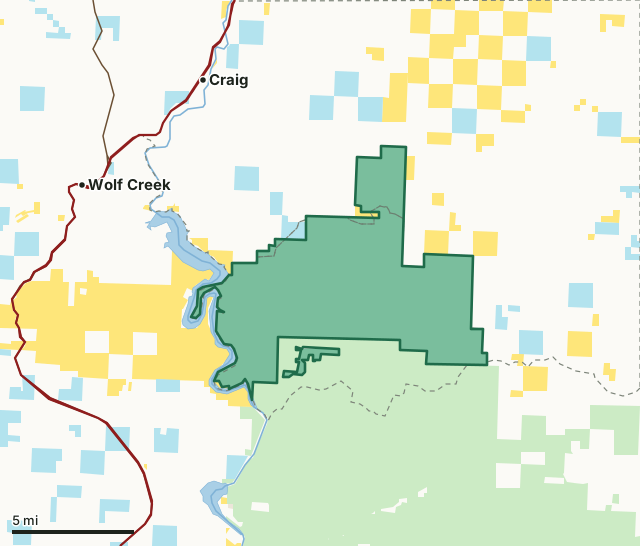
National forestBLMState trust landFWP landBeartooth WMAHunting district lineLake or riverHighway
| Size | 35,174 acres (FWP) |
|---|---|
| FWP region | Region 4, North-central Montana |
| Hunting districts | HD 455, HD 445 |
| Rules | Open from noon May 15 to December 1. |
| Camping | Allowed (FWP) |
| Hunter access | See travel plan map. Voluntary harvest check system. |
| Elevation | 4931 ft |
| Nearest towns | Wolf Creek (6 mi), Craig (7 mi) and Hardy (10 mi) |
What is Beartooth WMA for?
FWP bought the Beartooth WMA in 1970. Its first job is winter range for elk, mule deer and bighorn sheep, and it is open for hunting, fishing, riding, hiking and wildlife viewing. It lies at the northeast end of the Big Belt Mountains, just north of the Gates of the Mountains Wilderness, along the Missouri River and the southeast side of Holter Lake.
From FWP's Beartooth WMA page.
What are the rules on Beartooth WMA?
Open from noon May 15 to December 1. A travel plan map sets the access roads and the places to park and camp. Grizzly and black bears are present, and FWP's food storage rules apply.
Hunter access, as FWP puts it: See travel plan map. Voluntary harvest check system.
FWP prints a map of the area with its roads and rules: Beartooth WMA map (PDF). Hunting follows the regulations of the district the ground is in.
What can you hunt on Beartooth WMA?
FWP lists these big game animals for Beartooth WMA: antelope, bighorn sheep, elk, mountain lion, mule deer and white-tailed deer. Also listed: ruffed grouse and wolf.
Which hunting districts is Beartooth WMA in?
Beartooth WMA lies in 2 deer and elk districts. Each district's FWP harvest estimate, for the whole district, not the WMA alone:
| District | WMA acres in it | Elk harvested (district) | Deer harvested (district) |
|---|---|---|---|
| HD 455 Beartooth WMA | 31,604 | 124 (2025) | 35 (2025) |
| HD 445 Hound Creek | 3,417 | 521 (2025) | 879 (2025) |
Harvest: FWP Harvest Estimates (elk and deer, 2020 to 2025). WMA acres in each district measured by FilledTag from FWP's boundaries.
How do you get to Beartooth WMA?
In Lewis and Clark and Cascade counties about 40 miles north of Helena and 60 miles south of Great Falls. Exit I-15 at Wolf Creek and take the Missouri River Road east to Wolf Creek Bridge; turn south on Beartooth Road, which runs along the east side of the Missouri River and Holter Lake, and follow signs to the WMA.
Highways within 8 miles: I-15 and US 287. Nearest towns: Wolf Creek (6 miles), Craig (7 miles), Hardy (10 miles) and Helena Valley Northeast (12 miles).
Questions hunters ask
When is Beartooth WMA open?
Open from noon May 15 to December 1, by FWP's rule for the area. Hunting seasons are set by the district's regulations.
What can you hunt on Beartooth WMA?
FWP lists antelope, bighorn sheep, elk, mountain lion, mule deer, ruffed grouse, white-tailed deer and wolf for hunting or trapping on Beartooth WMA. Each species follows the regulations of the hunting district the ground is in (HD 455 and 445).
Can you camp on Beartooth WMA?
FWP lists camping as allowed on Beartooth WMA, with pack in/pack out, primitive campsite and toilet (vault). Follow the area's posted rules.
Which hunting district is Beartooth WMA in?
HD 455 (31,604 acres) and HD 445 (3,417 acres), by FWP's boundaries.
Get a Montana hunt plan when they open
Hunt plans for Montana are coming. Join the list and you'll hear first. The first 50 hunters in each new state get their plan free.
Until then, the free FilledTag app for iPhone has a map that works in every state, Montana included.
Where these facts come from
- Area description, rules, species, facilities and directions: FWP, Beartooth WMA.
- Boundary and acres: FWP wildlife management area boundaries. Surrounding public land: Montana Cadastral Public Lands, Montana State Library, published 2026.
- District harvest: FWP Harvest Estimates (elk and deer, 2020 to 2025).
FilledTag is not part of Montana Fish, Wildlife & Parks.