Freezout Lake Wildlife Management Area: hunting and access
Freezout Lake Wildlife Management Area is 11,294 acres of land managed by Montana Fish, Wildlife & Parks in Region 4, inside Hunting Districts 444 and 404. FWP's rule for the area: Open all year, except for the fall waterfowl closure.
Data updated October 2026. Area facts: FWP's page for Freezout Lake WMA, read 2026-10-17. Boundary: FWP GIS.
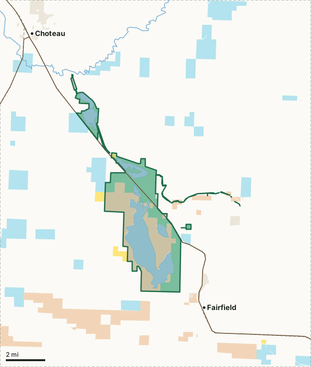
National forestBLMState trust landFWP landBureau of ReclamationOther publicFreezout Lake WMAHunting district lineLake or riverHighway
| Size | 11,294 acres (FWP) |
|---|---|
| FWP region | Region 4, North-central Montana |
| Hunting districts | HD 444, HD 404 |
| Rules | Open all year, except for the fall waterfowl closure. |
| Camping | Allowed (FWP) |
| Hunter access | See travel plan map. Travel plan specifies open/closed roads and specific parking/camping locations. |
| Elevation | 3777 ft |
| Nearest towns | Fairfield (next to it), Choteau (3 mi) and Simms (10 mi) |
What is Freezout Lake WMA for?
FWP bought Freezout Lake WMA in 1953 and developed it into the main Freezout Lake, Priest Butte Lake and their ponds. It is managed first for waterfowl production and for public hunting and viewing, and also for upland game birds. Spring and fall bring waterfowl migrations; winter brings upland birds and raptors.
From FWP's Freezout Lake WMA page.
What are the rules on Freezout Lake WMA?
Open all year, except for the fall waterfowl closure. A travel plan map sets the open and closed roads and the places to park and camp. FWP's restricted-area descriptions in its 2026 regulations include Freezout Lake WMA.
Hunter access, as FWP puts it: See travel plan map. Travel plan specifies open/closed roads and specific parking/camping locations.
FWP prints a map of the area with its roads and rules: Freezout Lake WMA map (PDF). Hunting follows the regulations of the district the ground is in.
Which hunting districts is Freezout Lake WMA in?
Freezout Lake WMA lies in 2 deer and elk districts. Each district's FWP harvest estimate, for the whole district, not the WMA alone:
| District | WMA acres in it | Elk harvested (district) | Deer harvested (district) |
|---|---|---|---|
| HD 444 Lower Sun River | 8,715 | 22 (2025) | 592 (2025) |
| HD 404 Lower Teton River | 2,579 | 3 (2025) | 994 (2025) |
Harvest: FWP Harvest Estimates (elk and deer, 2020 to 2025). WMA acres in each district measured by FilledTag from FWP's boundaries.
How do you get to Freezout Lake WMA?
Eastern Teton County in north central Montana 40 miles west of Great Falls along US Highway 89 between Fairfield and Choteau - Access to area from US Highway 89, or Frontage Road from Fairfield, to various turnouts and parking areas year-round.
Highways within 8 miles: US 89 and US 287. Nearest towns: Fairfield (next to it), Choteau (3 miles), Simms (10 miles) and Power (12 miles).
Questions hunters ask
When is Freezout Lake WMA open?
Open all year, except for the fall waterfowl closure, by FWP's rule for the area. Hunting seasons are set by the district's regulations.
Can you camp on Freezout Lake WMA?
FWP lists camping as allowed on Freezout Lake WMA, with pack in/pack out, picnic table, primitive campsite, toilet (vault) and unsheltered. Follow the area's posted rules.
Which hunting district is Freezout Lake WMA in?
HD 444 (8,715 acres) and HD 404 (2,579 acres), by FWP's boundaries.
Request your free Montana hunt plan
The first 50 hunters in Montana get one hunt plan free. Request yours now. We will email you when your plan is ready.
Use the map while you wait for your plan.
Where these facts come from
- Area description, rules, species, facilities and directions: FWP, Freezout Lake WMA.
- Boundary and acres: FWP wildlife management area boundaries. Surrounding public land: Montana Cadastral Public Lands, Montana State Library, published 2026.
- District harvest: FWP Harvest Estimates (elk and deer, 2020 to 2025).
FilledTag is not part of Montana Fish, Wildlife & Parks.