New Jersey Deer Management Zone 51: deer harvest, 2026-27 seasons and public land
New Jersey's Deer Management Zone 51 covers 351 square miles of Ocean and Monmouth counties. Hunters took 882 deer there in the 2025-26 seasons, down from 940 the year before, and fall bow gave the most, 312. For 2026-27 the zone follows NJFW's High regulation set. 9.9% of the zone is public land, the largest share national wildlife refuge (13,724 acres).
Data updated October 2026. Harvest: NJFW 2025-26 New Jersey Total Deer Harvest. Seasons: NJFW Deer Seasons 2026-27. Land: PAD-US.
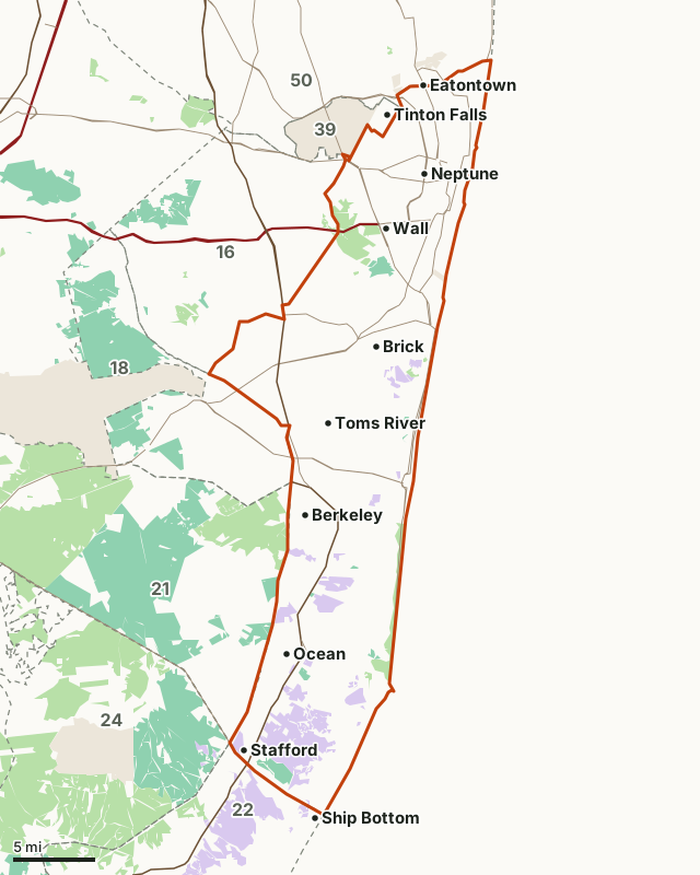
Fish and Wildlife land (WMAs)State forest and park landNational wildlife refugeMilitary (closed unless the base allows)Zone 51Neighboring zonesHighway
| Size | 351 square miles |
|---|---|
| Public land | 9.9% (22,276 acres) |
| Deer taken, 2025-26 | 882 |
| Deer taken, 2024-25 | 940 |
| Four-season average | 902 a season (2022-23 to 2025-26) |
| Busiest season, 2025-26 | Fall bow (312 deer) |
| 2026-27 rules | High regulation set |
| Deer taken per square mile, 2025-26 | 2.51 (deer taken divided by the zone's area) |
| Wildlife management areas | Manahawkin, Manasquan River, Upper Barnegat Bay, Sedge Island |
How many deer are taken in Zone 51 each season?
882 in 2025-26, 58 fewer than in 2024-25; across the four seasons below the zone averaged 902. Zone 51 gave 2.3% of New Jersey's 38,438 deer in 2025-26.
| Season | 2025-26 | 2024-25 | 2023-24 | 2022-23 |
|---|---|---|---|---|
| Fall bow | 312 | 362 | 284 | 322 |
| Permit bow | 242 | 260 | 264 | 244 |
| Permit muzzleloader | 20 | 25 | 28 | 26 |
| Permit shotgun | 126 | 119 | 115 | 116 |
| Six-day firearm | 75 | 67 | 66 | 85 |
| Winter bow | 106 | 101 | 131 | 100 |
| Youth bow day | 0 | 2 | 0 | 1 |
| Youth firearm day | 1 | 4 | 1 | 4 |
| All seasons | 882 | 940 | 889 | 898 |
Sources: NJFW 2025-26 New Jersey Total Deer Harvest; NJFW 2024-25 New Jersey Total Deer Harvest; NJFW 2023-24 New Jersey Total Deer Harvest; NJFW 2022-23 New Jersey Total Deer Harvest. Each table's zone rows add up to its Total row.
Which counties does Zone 51 cover?
| County | Acres in Zone 51 | County deer, 2025-26 | County deer, 2024-25 | County deer, 2021-22 |
|---|---|---|---|---|
| Ocean County | 163,069 | 1,605 | 1,761 | 1,674 |
| Monmouth County | 60,547 | 3,879 | 3,714 | 2,955 |
Source: NJFW White-tailed Deer Harvest by County, 2021-22 to 2025-26. County figures cover the whole county, not just Zone 51.
When are the 2026-27 deer seasons in Zone 51?
| Season | Dates | Bag limit |
|---|---|---|
| Fall bow | September 12 to October 2 (first deer must be antlerless, except youth license holders), then October 3 to 30, 2026 | Unlimited antlerless deer and one antlered deer |
| Youth archery day | September 26, 2026 | One deer of either sex |
| Permit bow | October 31 to December 24 and December 26 to 31, 2026 | Unlimited antlerless deer; one antlered deer with an Antlered Buck Bow Permit |
| Youth firearm day | November 21, 2026 | One deer of either sex |
| Six-day firearm | December 7 to 12, 2026 | Two antlered deer |
| Permit muzzleloader | Antlerless only November 23 to 25, 27 and December 7 to 12; either sex November 30, December 1, 14 to 24 and 26 to 31, 2026 and January 1 to February 20, 2027 | Unlimited antlerless deer; one antlered deer with an Antlered Buck Muzzleloader Permit |
| Permit shotgun | Antlerless only November 23 to 25, 27 and December 7 to 12, 2026; either sex December 14 to 18, 2026 and January 1 to February 20, 2027 | Unlimited antlerless deer; one antlered deer with an Antlered Buck Shotgun Permit |
| Winter bow | January 1 to February 20, 2027 | Unlimited antlerless deer and one antlered deer |
Only one antlered buck may be taken per season per hunter, except two in the six-day firearm season. Sunday hunting is legal only in archery seasons and only on WMAs and private land. Deer must be tagged at once and reported by 10 p.m. on the day of harvest.
Sources: NJFW Deer Seasons 2026-27; NJFW 2026-27 Deer Season Regulation Sets Reference Chart.
Where are Zone 51's boundaries?
NJFW's description: "That portion of Monmouth and Ocean Counties lying within a continuous line beginning at the intersection of Rt. 547 and Rt. 571 near Lakehurst; then southeast along Rt. 571 to the intersection with the Garden State Parkway; then south on the Garden State Parkway to its intersection with Rt. 72 near Manahawkin; then east along Rt. 72 to the Atlantic Ocean at Ship Bottom; then north along the Atlantic coastline to the intersection with Rt. 36 in Long Branch; then west on Rt. 36 to the intersection with the Garden State Parkway near Eatontown; then south on the parkway to the intersection with Rt. 547; then south on Rt. 547 to the intersection with county route 38 (Wayside Road) at the eastern fenced boundary of Naval Weapons Station, Earle; then south along the eastern fenced boundary of Naval Weapons Station, Earle to the intersection with Rt. 34; then south on Rt. 34 to the intersection with Tinton Falls Rd. and Rt. 33; then south on Tinton Falls Rd. to the intersection with Rt. 547 (Asbury Rd.); then south on Rt. 547 through Farmingdale to the intersection with Rt. 571, the point of beginning. Zone 53: Not Designated"
Source: NJFW Deer Management Zone Descriptions. NJFW suggests tracing the line on a county map; its Hunting and Trapping Explorer shows it too.
How much public land is in Zone 51?
9.9% of Zone 51 is public land: 22,276 of its 224,724 acres. The largest share is national wildlife refuge, 13,724 acres. NJFW notes that not every WMA is open to all hunting in every season; state parks and forests set their own rules and allow no Sunday hunting.
| Manager | Acres | Share of Zone 51 |
|---|---|---|
| National wildlife refuge | 13,724 | 6.1% |
| State forest and park land | 6,079 | 2.7% |
| Fish and Wildlife land (WMAs) | 2,473 | 1.1% |
| Military (closed unless the base allows) | 181 | 0.1% |
Measured by FilledTag inside the zone line from USGS Protected Areas Database of the United States (PAD-US 4.1).
Wildlife management areas in Zone 51
| WMA | Acres in Zone 51 | Municipality (NJDEP) |
|---|---|---|
| Manahawkin | 1,060 | Stafford |
| Manasquan River | 758 | Wall; Brick |
| Upper Barnegat Bay | 416 | Lacey, Ocean & Toms Rivers |
| Sedge Island | 205 | Lacey & Oceans |
| Manchester | 13 | Jackson, Manchester & Toms Rivers |
Which zones border Zone 51?
| Zone | 2026-27 rules | Square miles | Deer, 2025-26 | Deer, 2024-25 | Public land |
|---|---|---|---|---|---|
| Zone 16 | Medium | 129 | 811 | 809 | 6.3% |
| Zone 18 | Low | 89 | 359 | 368 | 29.9% |
| Zone 21 | Low | 207 | 388 | 391 | 55.9% |
| Zone 22 | Low | 130 | 155 | 149 | 32% |
| Zone 24 | Low | 167 | 162 | 221 | 60.6% |
| Zone 39 | Special Area | 17 | 93 | 120 | 0% |
| Zone 50 | High | 293 | 1,821 | 1,673 | 2% |
Highways crossing Zone 51: NJ 35 (54 miles), US 9 (34 miles), NJ 70 (22 miles), NJ 18 (18 miles), NJ 34 (18 miles) and NJ 71 (17 miles). Towns inside: Stafford, Berkeley, Toms River and Wall.
Questions hunters ask
How many deer were taken in New Jersey Deer Zone 51 in 2025-26?
882 (NJFW 2025-26 New Jersey Total Deer Harvest): 312 in fall bow, 242 in permit bow, 126 in permit shotgun, 106 in winter bow. The zone gave 940 in 2024-25, 889 in 2023-24 and 898 in 2022-23.
When is the six-day firearm season in Zone 51?
December 7 to 12, 2026, with a bag limit of two antlered deer, one at a time. Zone 51 uses the High regulation set: fall bow September 12 to October 2 (first deer must be antlerless, except youth license holders), then October 3 to 30, 2026, and winter bow January 1 to February 20, 2027 (NJFW Deer Seasons 2026-27).
How many antlerless deer can you take in Zone 51?
No limit in most seasons under the High regulation set: fall bow allows unlimited antlerless deer and one antlered deer, and the permit shotgun season allows unlimited antlerless deer; one antlered deer with an antlered buck shotgun permit (NJFW Deer Seasons 2026-27).
Where is New Jersey Deer Zone 51?
NJFW's description begins: "That portion of Monmouth and Ocean Counties lying within a continuous line beginning at the intersection of Rt. 547 and Rt. 571 near Lakehurst." The full boundary is on its zone description page (NJFW Deer Management Zone Descriptions).
Get a New Jersey hunt plan when they open
Hunt plans for New Jersey are coming. Join the list and you'll hear first. The first 50 hunters in each new state get their plan free.
Until then, the free FilledTag app for iPhone has a map that works in every state, New Jersey included.
Where these numbers come from
- Harvest: NJFW 2025-26 New Jersey Total Deer Harvest; earlier seasons' zone tables; NJFW Historic Deer Harvests, 1972 to 2025; NJFW White-tailed Deer Harvest by County, 2021-22 to 2025-26.
- Seasons and rules: NJFW Deer Seasons 2026-27; NJFW 2026-27 Deer Season Regulation Sets Reference Chart; NJFW Special Area Deer Hunting Regulations. Boundaries: NJFW Deer Management Zone Descriptions.
- Zone map: NJDEP Deer Management Zones (DMZ) in New Jersey. Public land: USGS Protected Areas Database of the United States (PAD-US 4.1). Highways and towns: U.S. Census Bureau TIGER/Line 2024 primary and secondary roads; U.S. Census Bureau 2024 Gazetteer, municipalities (county subdivisions).
FilledTag is not part of the New Jersey Department of Environmental Protection, Division of Fish and Wildlife. Numbers are copied from NJFW, NJDEP and federal sources or measured from their maps; nothing on this page is estimated by FilledTag.
New Jersey hunting Zone 16 Zone 18 Zone 21 Zone 22 Zone 24 Zone 39 Zone 50