Vance County deer harvest: North Carolina, 2016-17 to 2025-26
Hunters reported 1,398 deer in Vance County in the 2025-26 season: 688 antlered bucks and 646 does (NCWRC). That is 5.5 deer per square mile of land; by total the county ranked 65th of North Carolina's 100. The count was 5% above 2024-25 (1,334). NCWRC's records go back to 1976-77; the most in one season was 2,592 in 2013-14.
Data updated October 2026. Harvest: NCWRC reported deer harvest to the 2025-26 season. Seasons: NCWRC's 2026-27 dates.
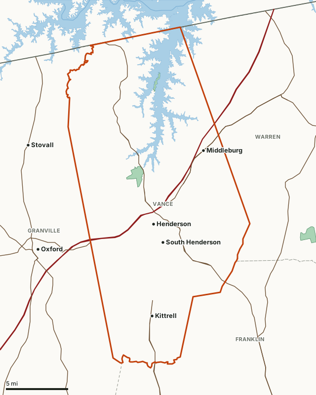
Vance CountyGame landsLake or riverHighwayCounty line
| Deer reported, 2025-26 | 1,398 (688 antlered bucks, 64 antlerless males, 646 does) |
|---|---|
| Per square mile of land | 5.5, 31st of 100 |
| Antlered bucks per square mile | 3.42 (NCWRC) |
| Average, 10 seasons | 1,290 deer a season |
| Most in one season since 1976 | 2,592 in 2013-14 |
| Deer season zone | Northeastern (gun opens Oct. 17) |
| NCWRC district | District 3, Piedmont; N. Piedmont unit |
| On game lands, 2025-26 | 82 deer |
| Land area | 252.4 square miles (Census) |
| Public land mapped here | 1 game land, 853 acres |
| Towns | Henderson, Middleburg and Kittrell |
How many deer are killed in Vance County each season?
The average over the last 10 seasons was 1,290; the most was 1,547 in 2017-18 and the fewest 1,075 in 2018-19. 2025-26 was 5% above 2016-17.
| Season | Deer reported | Per square mile |
|---|---|---|
| 2025-26 | 1,398 | 5.5 |
| 2024-25 | 1,334 | 5.3 |
| 2023-24 | 1,367 | 5.4 |
| 2022-23 | 1,115 | 4.4 |
| 2021-22 | 1,261 | 5 |
| 2020-21 | 1,168 | 4.6 |
| 2019-20 | 1,309 | 5.2 |
| 2018-19 | 1,075 | 4.3 |
| 2017-18 | 1,547 | 6.1 |
| 2016-17 | 1,327 | 5.3 |
How the last 2 seasons' deer were taken, and where:
| Season | Antlered bucks | Antlerless males | Does | Gun | Blackpowder | Bow | Crossbow | Game lands | Other land |
|---|---|---|---|---|---|---|---|---|---|
| 2025-26 | 688 | 64 | 646 | 1,237 | 56 | 57 | 48 | 82 | 1,316 |
| 2024-25 | 623 | 73 | 638 | 1,151 | 38 | 76 | 69 | 90 | 1,244 |
Sources: NCWRC reported deer harvest by county, 1976-2024; NCWRC 2024-25 reported deer harvest by county; NCWRC 2025-26 reported deer harvest by county. Per square mile uses the county's 252.4 square miles of land (Census).
When is deer season in Vance County in 2026-27?
Vance County is in NCWRC's Northeastern deer zone. Its 2026-27 dates:
| Method | Antlered deer | Antlerless deer |
|---|---|---|
| Archery | Sept. 12 to Oct. 2, 2026 | Same as antlered |
| Blackpowder | Oct. 3 to 16, 2026 | Same as antlered |
| Gun | Oct. 17, 2026 to Jan. 1, 2027 | Same as antlered |
Source: NCWRC hunting and trapping season dates, 2026-27. On game lands, the game land's hunting days also apply.
Where is the public hunting land in Vance County?
| Game land | Acres in Vance County | Deer on the whole game land, 2025-26 |
|---|---|---|
| Vance Game Land | 853 | 82 |
Acres measured by FilledTag on NCWRC game land boundaries, U.S. Forest Service national forest ownership and U.S. Fish and Wildlife Service refuge boundaries.
How does Vance County compare with its neighbors?
| County | Zone | Deer, 2025-26 | Per square mile | Change since 2016-17 |
|---|---|---|---|---|
| Vance County | Northeastern | 1,398 | 5.5 | 5% |
| Franklin County | Northeastern | 2,411 | 4.9 | 15% |
| Granville County | Central | 3,125 | 5.9 | 64% |
| Warren County | Northeastern | 1,476 | 3.4 | -19% |
Questions hunters ask
How many deer were killed in Vance County, NC last season?
NCWRC reports 1,398 deer taken in Vance County in the 2025-26 season: 688 antlered bucks, 64 antlerless males and 646 does. 1,237 were taken with a gun, 56 with blackpowder, 57 with a bow and 48 with a crossbow.
When is deer season in Vance County in 2026-27?
Vance County is in the Northeastern deer zone: archery Sept. 12 to Oct. 2, 2026; blackpowder Oct. 3 to 16, 2026; gun Oct. 17, 2026 to Jan. 1, 2027 (NCWRC 2026-27 season dates).
Is there public hunting land in Vance County?
Yes. NCWRC's map puts Vance Game Land (853 acres in the county) in Vance County.
Has the deer harvest in Vance County gone up or down?
From 1,327 in 2016-17 to 1,398 in 2025-26, 5% higher. The most since NCWRC's records began was 2,592 in 2013-14.
Get a North Carolina hunt plan when they open
Hunt plans for North Carolina are coming. Join the list and you'll hear first. The first 50 hunters in each new state get their plan free.
Until then, the free FilledTag app for iPhone has a map that works in every state, North Carolina included.
Where these numbers come from
- Deer harvest: NCWRC reported deer harvest by county, 1976-2024; NCWRC 2024-25 reported deer harvest by county; NCWRC 2025-26 reported deer harvest by county.
- Deer zones and dates: NCWRC hunting and trapping season dates, 2026-27.
- Public land: NCWRC game land boundaries; U.S. Forest Service national forest ownership; U.S. Fish and Wildlife Service refuge boundaries. County land area: U.S. Census Bureau 2024 county boundaries. Highways and towns: U.S. Census Bureau TIGER/Line 2024 roads; U.S. Census Bureau 2024 Gazetteer.
FilledTag is not part of the NC Wildlife Resources Commission. Numbers are copied from NCWRC and the Census Bureau or measured from public maps; nothing here is estimated by FilledTag.
North Carolina hunting North Carolina deer harvest by county Franklin County Granville County Warren County