Light Ground Pocosin Game Land: hunting rules, deer harvest and access
Light Ground Pocosin Game Land is 942 acres of public hunting land in Pamlico County, a Seven Days per Week area by NCWRC's rule for it. Hunters reported 1 deer on it in the 2025-26 season, 1 antlered buck among them (NCWRC). NC Wildlife Resources Commission owns nearly all of it.
Data updated October 2026. Rules: 15A NCAC 10D as NCWRC adopted it. Harvest: NCWRC's game land reports, 2023-24 to 2025-26. Seasons: NCWRC's 2026-27 dates.
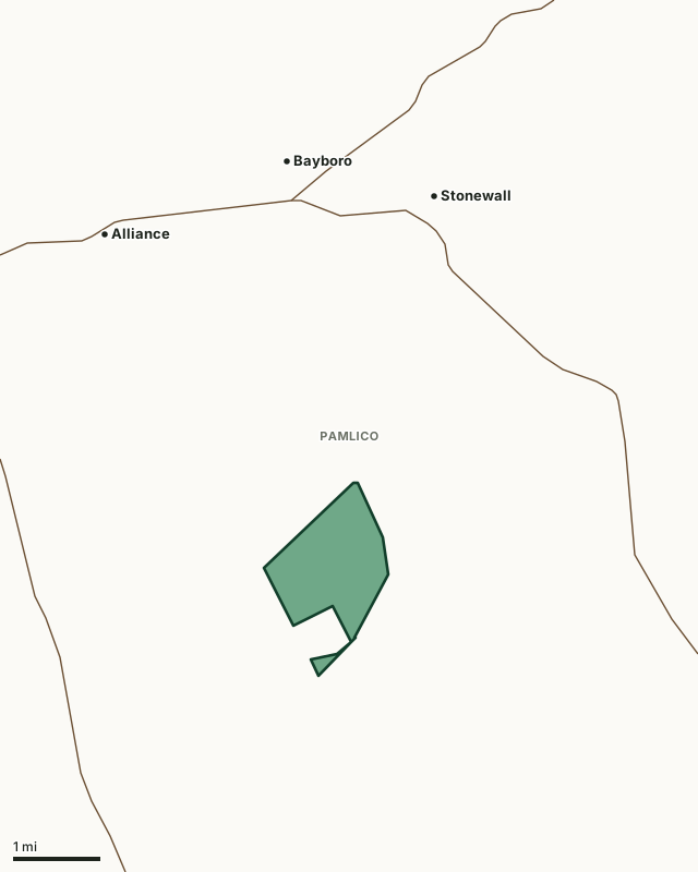
Light Ground Pocosin Game LandOther NCWRC game landsLake or riverHighwayCounty line
| Size | 942 acres (NCWRC) |
|---|---|
| County | Pamlico County |
| Hunting days | Seven Days per Week Area |
| Owner | NC Wildlife Resources Commission (942 acres) |
| Deer reported, 2025-26 | 1 (1 antlered buck, 0 does) |
| Target shooting | Not prohibited on 942 acres, by NCWRC's tract data; posted rules apply |
| Nearest towns | Stonewall (3 mi), Bayboro (4 mi) and Arapahoe (4 mi) |
What are the rules on Light Ground Pocosin Game Land?
Seven Days per Week Area: Hunting every day of the open seasons.
- Light Ground Pocosin game land is a Seven Days per Week Area, in which the following applies:
- (1) Deer of either sex may be taken on all the open days of the applicable Deer With Visible Antlers Season.
- (2) Bear shall not be harvested on Sunday.
Source: 15A NCAC 10D .0246, in effect since October 1, 2022. Game land rules apply on top of the county's season dates.
How many deer are taken on Light Ground Pocosin Game Land?
NCWRC reports 1 deer on Light Ground Pocosin Game Land in the 2025-26 season. That compares with 4 in 2024-25 and 3 in 2023-24.
| Season | Deer reported | Antlered bucks | Antlerless males | Does |
|---|---|---|---|---|
| 2025-26 | 1 | 1 | 0 | 0 |
| 2024-25 | 4 | 3 | 0 | 1 |
| 2023-24 | 3 | 1 | 0 | 2 |
Source: NCWRC reported deer harvest by game land, 2023-24 to 2025-26; NCWRC 2024-25 deer harvest by game land; NCWRC 2023-24 deer harvest by game land. NCWRC's 2023-24 report calls antlerless males button bucks.
Who owns Light Ground Pocosin Game Land?
Game lands are owned by NCWRC or by partners who open their land to public hunting under NCWRC's rules. NCWRC's tract data for Light Ground Pocosin Game Land:
| Owner | Acres |
|---|---|
| NC Wildlife Resources Commission | 942 |
Source: NCWRC game land tracts.
Which county is Light Ground Pocosin Game Land in?
| County | Acres of the game land in it | Deer season zone | Gun season opens, 2026 | County deer, 2025-26 |
|---|---|---|---|---|
| Pamlico County | 943 | Southeastern | Oct. 17 | 1,063 |
Acres measured by FilledTag on NCWRC game land boundaries and the U.S. Census Bureau 2024 county boundaries. Zones and dates: NCWRC hunting and trapping season dates, 2026-27. County harvest: NCWRC 2025-26 reported deer harvest by county.
How do you get to Light Ground Pocosin Game Land?
Highways within 5 miles: NC 306, NC 55 and NC 304. Nearest towns: Stonewall (3 miles), Bayboro (4 miles), Arapahoe (4 miles) and Alliance (4 miles).
The closest other game lands with a page here: Goose Creek Game Land (7 miles), Neuse River Game Land (8.9 miles), Croatan Game Land (9 miles) and Carteret County Game Land (13 miles).
On Sundays on game lands, firearm hunting is not allowed between 9:30 a.m. and 12:30 p.m., deer may not be taken with a firearm while being chased by dogs, and migratory game birds may not be hunted (15A NCAC 10D .0103).
Questions hunters ask
What days can you hunt Light Ground Pocosin Game Land?
Light Ground Pocosin Game Land is a Seven Days per Week Area (15A NCAC 10D .0246). Hunting every day of the open seasons.
How many deer are killed on Light Ground Pocosin Game Land?
NCWRC reports 1 deer taken on Light Ground Pocosin Game Land in the 2025-26 season: 1 antlered buck, 0 antlerless males and 0 does. The two seasons before: 4 in 2024-25 and 3 in 2023-24.
What county is Light Ground Pocosin Game Land in?
All of it is in Pamlico County, by NCWRC's boundary.
When is deer gun season on Light Ground Pocosin Game Land in 2026-27?
The county's zone sets the dates: Pamlico County (Southeastern zone) opens gun season Oct. 17, and it runs to January 1, 2027 (NCWRC 2026-27 season dates). The game land's hunting days still apply.
Get a North Carolina hunt plan when they open
Hunt plans for North Carolina are coming. Join the list and you'll hear first. The first 50 hunters in each new state get their plan free.
Until then, the free FilledTag app for iPhone has a map that works in every state, North Carolina included.
Where these numbers come from
- Game land rules: NCWRC game land rules, 15A NCAC 10D. Designations, owners and tracts: NCWRC game land tracts.
- Deer harvest on the game land: NCWRC reported deer harvest by game land, 2023-24 to 2025-26. County harvest: NCWRC 2025-26 reported deer harvest by county.
- Boundary: NCWRC game land boundaries. Counties, highways and towns: U.S. Census Bureau 2024 county boundaries; U.S. Census Bureau TIGER/Line 2024 roads; U.S. Census Bureau 2024 Gazetteer. National forest and refuges: U.S. Forest Service national forest ownership; U.S. Fish and Wildlife Service refuge boundaries.
FilledTag is not part of the NC Wildlife Resources Commission. Numbers are copied from NCWRC or measured from public maps; nothing on this page is estimated by FilledTag.
North Carolina hunting All North Carolina game lands Pamlico County deer harvest