Pronghorn unit 13A, North Dakota: licenses, lottery and hunting land
North Dakota pronghorn unit 13A covers 5,067 square miles, across Williams, Divide, Burke and Mountrail counties. In the 2026 pronghorn lottery NDGF made 60 licenses available in unit 13A (60 any pronghorn). 1,099 residents named it as their first choice, and 30 of them drew. 6.6% of the unit is public land, mostly state trust land, and 68,533 acres are PLOTS walk-in land on private ground (NDGF map layers, 2026).
Data updated October 2026. Lottery: NDGF, 2020 to 2026. Land: NDGF map layers, 2026. Seasons: NDGF 2026-27 table.
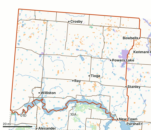
NDGF wildlife management areaWaterfowl production areaNational wildlife refuge (rules vary)BLMCorps of EngineersBureau of ReclamationState trust landState park (rules vary)National park (no hunting)PLOTS (private land open to hunting)Unit 13ANeighboring unitsLake or riverHighway
| Size | 3,243,146 acres (5,067 square miles) |
|---|---|
| Counties | Williams, Divide, Burke, Mountrail |
| Licenses, 2026 lottery | 60: 60 any pronghorn |
| First-choice resident applicants, 2026 | 1,099 |
| Public land | 6.6% (213,866 acres) |
| PLOTS walk-in land | 68,533 acres; 313 tracts centered in the unit |
| Wildlife management areas | 13 (9,298 acres) |
| Pronghorn gun season, 2026 | October 2 to 18, 2026 |
| Towns in and near it | Williston, Stanley, Tioga, Bowbells and Palermo |
How many pronghorn licenses does unit 13A get?
In the 2026 pronghorn lottery NDGF made 60 licenses available in unit 13A (60 any pronghorn). 1,099 residents named it as their first choice, and 30 of them drew. NDGF made 75 licenses available here in 2020 and 60 in 2026.
| Year | License | Licenses available | Set aside for landowners (gratis) | Issued in the resident drawing (all choices) | First-choice resident applicants | First-choice applicants who drew | Share who drew |
|---|---|---|---|---|---|---|---|
| 2026 | Any Pronghorn | 60 | 30 | not printed | 1,099 | 30 | 3% |
| 2025 | Any Pronghorn | 60 | 30 | not printed | 1,084 | 30 | 3% |
| 2024 | Any Pronghorn | 60 | 29 | not printed | 843 | 31 | 4% |
| 2022 | A - Any Pronghorn | 75 | 29 | not printed | 1,064 | 46 | 4% |
| 2021 | Any Pronghorn | 75 | 30 | not printed | 1,040 | 45 | 4% |
| 2020 | Any Pronghorn | 75 | 26 | not printed | 963 | 49 | 5% |
Source: NDGF pronghorn lottery statistics and NDGF pronghorn lottery archive; NDGF notes small differences from voided, revoked or refunded licenses. "First-choice applicants who drew" adds up NDGF's successful applicants at every bonus point level; "share who drew" divides it by first-choice resident applicants, for that year only. It is not a forecast.
How many bonus points did it take to draw unit 13A in 2026?
Any Pronghorn: 30 of 1,099 resident first-choice applicants drew; 0 of the 234 with no bonus points did; the first draws came at 4 points.
| Bonus points | Any Pronghorn: drew / applied |
|---|---|
| 0 | 0 / 234 |
| 1 | 0 / 221 |
| 2 | 0 / 125 |
| 3 | 0 / 123 |
| 4 | 1 / 114 |
| 5 | 2 / 95 |
| 6 | 4 / 73 |
| 7 | 8 / 47 |
| 8 | 8 / 30 |
| 9 | 3 / 17 |
| 10 | 2 / 8 |
| 11 | 1 / 6 |
| 12 | 1 / 4 |
| 13 | 0 / 1 |
| 14 | 0 / 1 |
Source: NDGF pronghorn lottery statistics, "Bonus Points (Successful Applicants/Total Applicants)". The top column is NDGF's own top bucket. An applicant who does not draw a first choice earns a bonus point for the next lottery.
How much public land and PLOTS is in unit 13A?
6.6% of unit 13A is public land: 213,866 of its 3,243,146 acres. The largest share is state trust land, 91,147 acres. PLOTS adds 68,533 acres of private land open to walk-in hunting; 313 PLOTS tracts are centered inside the unit.
| Manager | Acres | Share of unit 13A |
|---|---|---|
| State trust land | 91,147 | 2.8% |
| PLOTS (private land open to hunting) | 68,533 | 2.1% |
| Corps of Engineers | 61,874 | 1.9% |
| National wildlife refuge (rules vary) | 30,508 | 0.9% |
| Waterfowl production area | 19,584 | 0.6% |
| NDGF wildlife management area | 9,550 | 0.3% |
| BLM | 1,178 | under 0.1% |
| National park (no hunting) | 362 | under 0.1% |
| State park (rules vary) | 192 | under 0.1% |
| Bureau of Reclamation | 25 | under 0.1% |
Wildlife management areas in unit 13A: Trenton WMA (4,894 acres here), Hofflund WMA (1,500 acres here), Harris M. Baukol WMA (1,271 acres here), Salt Flats WMA (321 acres here), Blue Ridge WMA (254 acres here), Smishek Lake WMA (202 acres here), McGregor Dam WMA (194 acres here), Short Creek WMA (164 acres here), Leaf Mountain WMA (162 acres here), Dry Fork WMA (161 acres here), Kerr Slough WMA (89 acres here) and Blacktail Dam WMA (47 acres here), and 1 smaller ones.
Measured by FilledTag inside NDGF's unit boundary from NDGF PLOTS Guide map layers (WMAs, PLOTS, trust land, federal land). Where two maps overlap, the acres are counted once. State trust land is open to walk-in hunting unless the Department of Trust Lands lists the tract as closed; some tracts ask that the lessee be told first. National wildlife refuges are open to hunting only where each refuge's rules allow.
Which counties does unit 13A cover?
Unit 13A takes in parts of 4 counties. Each county's page lists its PLOTS land and WMAs.
| County | Acres in unit 13A | Share of the unit |
|---|---|---|
| Williams County | 1,374,339 | 42.4% |
| Divide County | 828,251 | 25.5% |
| Burke County | 550,282 | 17% |
| Mountrail County | 489,604 | 15.1% |
When is pronghorn season in unit 13A in 2026?
Every pronghorn license is good with a bow from the first date below, then with a gun or bow in the later season, in the unit printed on it.
| Season | Where | Opens | Closes | Apply by |
|---|---|---|---|---|
| Pronghorn: Bow | Units 1A, 1D, 2A, 2B, 3A, 3B, 4A, 4C, 5A, 6A, 7A, 8A, 9A, 9C, 10A, 11A, 13A, 17A | September 4, 2026 | September 27, 2026 | no lottery |
| Pronghorn: Gun or Bow | Units 1A, 1D, 2A, 2B, 3A, 3B, 4A, 4C, 5A, 6A, 7A, 8A, 9A, 9C, 10A, 11A, 13A, 17A | October 2, 2026 | October 18, 2026 | August 5, 2026 |
Source: NDGF 2026-27 season dates.
How do you get to unit 13A?
Highways through the unit: US 2 (about 143 miles inside it), ND 1804 (about 103 miles inside it), US 85 (about 95 miles inside it), ND 5 (about 85 miles inside it) and ND 50 (about 79 miles inside it). Towns inside: Williston, Stanley, Tioga, New Town, White Earth, Crosby and 20 more. Just outside: Bowbells (on the line), Palermo (7 miles), Parshall (10 miles) and Kenmare (12 miles).
Which units border pronghorn unit 13A?
Unit 13A touches 2 other pronghorn units. Their 2026 licenses and land, for comparison:
| Unit | Licenses, 2026 | First-choice applicants | Public land | PLOTS acres |
|---|---|---|---|---|
| Unit 01D | 100 | 2,363 | 46.6% | 1,784 |
| Unit 10A | 50 | 351 | 21.9% | 4,935 |
Questions hunters ask
How many bonus points does it take to draw pronghorn unit 13A?
30 of 1,099 resident first-choice applicants drew; 0 of the 234 with no bonus points did; the first draws came at 4 points. Those are NDGF's 2026 figures for any pronghorn licenses in unit 13A; the full table by point level is above. A coming year can differ.
How much public land is in pronghorn unit 13A?
6.6% of unit 13A, 213,866 of its 3,243,146 acres, is public land by the state and federal maps NDGF publishes; the largest share is state trust land at 91,147 acres. Another 68,533 acres are PLOTS, private land the owner has opened to walk-in hunting.
What towns are in pronghorn unit 13A?
Williston, Stanley, Tioga, New Town and White Earth are inside the unit, with 21 smaller places.
When is pronghorn season in unit 13A in 2026?
Bow only from September 4 to 27, 2026, then gun or bow from October 2 to 18, 2026, in unit 13A only. Dates are from NDGF's 2026-27 season table; the lottery deadline was August 5, 2026.
Get a North Dakota hunt plan when they open
Hunt plans for North Dakota are coming. Join the list and you'll hear first. The first 50 hunters in each new state get their plan free.
Until then, the free FilledTag app for iPhone has a map that works in every state, North Dakota included.
Where these numbers come from
- Licenses, applicants and bonus points: NDGF pronghorn lottery statistics; NDGF pronghorn lottery archive.
- Seasons: NDGF 2026-27 season dates.
- Unit boundary: NDGF hunting unit maps. Land: NDGF PLOTS Guide map layers (WMAs, PLOTS, trust land, federal land). Highways and towns: U.S. Census Bureau TIGER/Line 2024 and 2024 Gazetteer.
FilledTag is not part of the North Dakota Game and Fish Department. Numbers are copied from NDGF or measured from the maps it publishes; nothing on this page is estimated by FilledTag.
North Dakota hunting Unit 01D Unit 10A Williams County Divide County Burke County