Unit 45 Fossil deer hunting: harvest, hunts and 2026 seasons
ODFW estimates hunters took 414 deer in the Fossil Unit (45) in 2025 (383 bucks and 30 antlerless) and counted 1,300 deer hunters there, across 5 general seasons and controlled hunts. ODFW's figures for 2021 to 2025 average 457 deer a year. The unit is 15.3% public land, most of it BLM, by USGS PAD-US.
Data updated October 2026. Harvest: ODFW, 2021 to 2025. Seasons and tags: ODFW's 2026 regulations and 2026 draw. Land: USGS PAD-US 4.1.
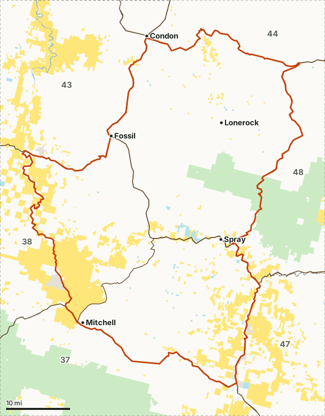
National park land (no hunting)National forestBLMState forest and trust landOther public (city, county, parks, military)Unit 45Neighboring unitsLake, reservoir or riverHighway
| ODFW zone | Northeast |
|---|---|
| Size | 902,553 acres (1,410 square miles) |
| Public land | 15.3% (137,858 acres) |
| Deer harvested, 2025 | 414 (383 bucks) |
| Deer hunters, 2025 | 1,300, 6,039 days |
| Deer per 100 hunters, 2025 | 32 |
| General season | Controlled hunts only (by deer hunt area) |
| 2026 controlled hunts listed here | 11 |
| Towns in and near it | Mitchell, Lonerock, Fossil and Condon |
How many deer are harvested in Unit 45?
ODFW's deer harvest for the Fossil Unit by year: 414 in 2025, 489 in 2024 and 504 in 2023. 32 deer were taken for every 100 hunters in 2025.
| Year | Hunters | Days hunted | Deer harvested | Bucks | Antlerless | Deer per 100 hunters |
|---|---|---|---|---|---|---|
| 2025 | 1,300 | 6,039 | 414 | 383 | 30 | 32 |
| 2024 | 1,219 | 5,336 | 489 | 451 | 38 | 40 |
| 2023 | 1,442 | 6,747 | 504 | 478 | 26 | 35 |
| 2022 | 1,473 | 7,027 | 403 | 368 | 35 | 27 |
| 2021 | 1,583 | 7,628 | 475 | 428 | 47 | 30 |
Source: ODFW harvest statistics (2021 to 2025), from ODFW's mandatory harvest reporting. Each year adds up ODFW's rows for the unit across its any legal weapon buck, archery, muzzleloader and antlerless summaries, general and controlled. A hunter counted on two tag types is counted twice. Per 100 hunters is worked out from ODFW's two figures.
Which deer hunts were used in Unit 45 in 2025?
Controlled hunts: 5 rows in ODFW's table, 1,300 hunters, 414 deer. ODFW's own row for each, 2025:
| Hunt or season | Tag type | Hunters | Days | Harvested | ODFW success |
|---|---|---|---|---|---|
| 145 Fossil Unit No. 1 | Any legal weapon buck, controlled | 1,105 | 4,848 | 349 | 32% |
| 145R Fossil Unit Bow | Archery, controlled | 75 | 655 | 11 | 14% |
| 145M Flatiron Muzzleloader | Muzzleloader, controlled | 60 | 338 | 17 | 28% |
| 645 Fossil Private | Antlerless, controlled | 45 | 124 | 25 | 54% |
| 145A Fossil Unit No. 2 | Any legal weapon buck, controlled | 15 | 74 | 12 | 79% |
Source: ODFW's 2025 deer harvest summaries (ODFW harvest statistics (2025)). A hunt that spans several units is split by unit in ODFW's tables; these are the Fossil rows.
When is deer season in Unit 45 in 2026?
Starting in 2026, ODFW structures eastern Oregon deer hunts by deer hunt area, not by wildlife management unit, and every eastern buck deer hunt is a controlled hunt (pages 30-43).
Controlled deer hunts in ODFW's 2026 tables that include the unit, with ODFW's 2026 tags and its June 2026 draw (residents who drew, of residents who put the hunt first):
| Hunt | Name | Bag limit | 2026 season | 2026 tags | 2026 draw, residents |
|---|---|---|---|---|---|
| NB102 | North Blues 02 | One buck with visible antler | Oct. 3 - Oct. 14 | 2,420 | 1,224 of 1,224 |
| FX103 | Fox 03 | One buck with visible antler | Oct. 3 - Oct. 14 | 1,980 | 1,900 of 2,260 |
| PH101 | Painted Hills 01 | One buck with visible antler | Oct. 3 - Oct. 14 | 1,254 | 1,214 of 3,020 |
| FX103R | Fox 03 Bow | One buck with visible antler | Aug. 29 - Sep. 27 | 770 | 210 of 210 |
| NB102R | North Blues 02 Bow | One buck with visible antler | Aug. 29 - Sep. 27 | 440 | 43 of 43 |
| PH101R | Painted Hills 01 Bow | One buck with visible antler | Aug. 29 - Sep. 27 | 330 | 258 of 258 |
| FX103M | Fox 03 Muzzleloader | One buck with visible antler | Oct. 17 - Oct. 25 | 242 | 236 of 269 |
| NB602T | North Blues 02 Youth | One antlerless deer | Nov. 21 - Dec. 6 | 50 | 50 of 59 |
| FX603 | Fox 03 Private | One antlerless deer | Oct. 17 - Oct. 25 | 22 | 22 of 184 |
| NB602 | North Blues 02 Private | One antlerless deer | Oct. 17 - Oct. 25 | 22 | 22 of 316 |
| FX103-1 | Late Fox 03 | One buck with visible antler | Nov. 21 - Nov. 29 | 11 | 10 of 1,120 |
Source: ODFW 2026 Oregon Big Game Hunting Regulations, pages 30 to 45; draw: ODFW's 2026 Preference Point Draw Reports. Hunts are matched to the unit by ODFW's own harvest rows and the 2026 deer hunt areas. Check ODFW before you go; seasons can change.
Which 2026 deer hunt areas cover Unit 45?
Starting in 2026, ODFW structures eastern Oregon deer hunts by deer hunt area, not by wildlife management unit, and every eastern buck deer hunt is a controlled hunt (pages 30-43). By ODFW's hunt area map, the Fossil Unit is split between 3 hunt areas. The 2026 buck hunts in each:
| Hunt area | Herd range | Share of Unit 45 | 2026 buck hunts (tags) |
|---|---|---|---|
| FX-03 | Fox | 44.7% | FX103 Fox 03 (1,980); FX103-1 Late Fox 03 (11); FX103R Fox 03 Bow (770); FX103M Fox 03 Muzzleloader (242) |
| NB-02 | North Blues | 31.8% | NB102 North Blues 02 (2,420); NB102R North Blues 02 Bow (440) |
| PH-01 | Painted Hills | 23.5% | PH101 Painted Hills 01 (1,254); PH101R Painted Hills 01 Bow (330) |
Hunt area shares measured by FilledTag from ODFW eastern Oregon mule deer hunt areas (2026); hunts and tags from ODFW 2026 Oregon Big Game Hunting Regulations, pages 34 to 43. Harvest by hunt area starts with ODFW's 2026 report; the harvest above is by unit, 2021 to 2025.
How much public land is in Unit 45?
15.3% of the Fossil Unit is public land open to hunting under its manager's rules: 137,858 of 902,553 acres. The largest share is BLM, 103,873 acres.
| Manager | Acres | Share of unit |
|---|---|---|
| BLM | 103,873 | 11.5% |
| National forest | 30,174 | 3.3% |
| State forest and trust land | 3,811 | 0.4% |
| National park land (no hunting) | 566 | 0.1% |
| Other public (city, county, parks, military) | 37 | under 0.1% |
Measured by FilledTag inside ODFW's unit boundary from USGS PAD-US 4.1 (fee land by manager, 2025). Tribal and private land are not counted as public.
How do you get to Unit 45?
Highways through the unit: US 26 (about 106 miles inside it), OR 19 (about 80 miles inside it), OR 207 (about 56 miles inside it), OR 206 (about 35 miles inside it) and OR 218 (about 12 miles inside it). Towns inside: Mitchell, Lonerock, Fossil and Spray.
Which units border Unit 45?
The Fossil Unit touches 6 other units. Their public land and ODFW's latest deer figures, for comparison:
| Unit | Public land | Deer hunters | Deer harvested | Year |
|---|---|---|---|---|
| Unit 37 Ochoco | 54% | 1,664 | 350 | 2025 |
| Unit 38 Grizzly | 27.1% | 1,027 | 333 | 2025 |
| Unit 43 Biggs | 12.3% | 1,205 | 679 | 2025 |
| Unit 44 Columbia Basin | 1.3% | 1,525 | 932 | 2025 |
| Unit 47 Northside | 40.3% | 1,055 | 297 | 2025 |
| Unit 48 Heppner | 34.1% | 2,326 | 526 | 2025 |
Also for Unit 45: elk hunting, pronghorn hunting.
Questions hunters ask
Can you hunt deer in Unit 45 without drawing a tag?
No. In 2026 every deer hunt in the Fossil Unit is a controlled hunt drawn by ODFW, now set by deer hunt area rather than unit. ODFW lists 11 controlled hunts for it in the 2026 regulations.
How many deer are taken in Unit 45 each year?
ODFW estimates 414 in 2025, 489 in 2024 and 504 in 2023, adding up its rows for the Fossil Unit across general and controlled deer tags.
What is the closest town to Unit 45?
Mitchell, Lonerock and Fossil are inside the unit. Just outside: Condon (on the line), Dayville (7 miles) and Heppner (9 miles).
Get an Oregon hunt plan when they open
Hunt plans for Oregon are coming. Join the list and you'll hear first. The first 50 hunters in each new state get their plan free.
Until then, the free FilledTag app for iPhone has a map that works in every state, Oregon included.
Where these numbers come from
- Harvest, hunters and days: ODFW harvest statistics (2021 to 2025).
- Seasons, hunts, tags and bag limits: ODFW 2026 Oregon Big Game Hunting Regulations. Draw: ODFW 2026 Preference Point Draw Reports.
- Public land: USGS PAD-US 4.1 (fee land by manager, 2025). Unit boundary: ODFW Wildlife Management Units (Compass dataset).
- Highways, water and towns: U.S. Census Bureau TIGER/Line 2024 and the 2024 Gazetteer.
FilledTag is not part of Oregon Department of Fish and Wildlife. Numbers are copied from ODFW and USGS, or measured from their maps; nothing on this page is estimated by FilledTag.
Oregon hunting Northeast zone Unit 37 deer Unit 38 deer Unit 43 deer Unit 44 deer Unit 47 deer Unit 48 deer