Ladd Marsh Wildlife Area: hunting rules, map and access
Ladd Marsh Wildlife Area is 5,610 acres of land managed by Oregon Department of Fish and Wildlife, in the Catherine Creek Unit (53) and Starkey Unit (52), by ODFW's mapped boundary. ODFW's 2026 rule for the area begins: "All land north and east of Foothill Rd are open to big game hunting Wed., Sat., Sun. and Federal holidays August 1 through January 31."
Data updated October 2026. Rules: ODFW's 2026 regulations, page 89. Boundary: ODFW. Land around it: USGS PAD-US 4.1.
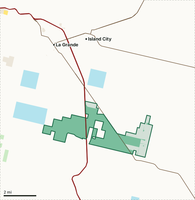
National wildlife refugeNational forestBLMODFW landState forest and trust landLadd Marsh Wildlife AreaUnit lineLake, reservoir or riverHighway
| Size | 5,610 acres (ODFW boundary, measured) |
|---|---|
| Units | 53 Catherine Creek, 52 Starkey |
| ODFW zone | Northeast |
| First rule | All land north and east of Foothill Rd are open to big game hunting Wed., Sat., Sun. and Federal holidays August 1 through January 31 |
| Nearest towns | Island City (4 mi), La Grande (4 mi) and Union (4 mi) |
What is Ladd Marsh Wildlife Area?
Following droughts in the 1930s that affected most of North America, major conservation efforts, by both private and governmental entities, were enacted to reverse trends of degrading and disappearing wetlands. During this time period there was a major creation and expansion of federal wildlife refuges and state wildlife areas. As the concept of waterfowl flyway management was endorsed and developed, wildlife areas were acquired and managed as part of a larger plan focused on migratory waterfowl needs. LMWA was one of several wetland-focused wildlife areas established in Oregon. Ladd Marsh Wildlife Area was established in 1949, with primary objectives of protecting and improving waterfowl habitat and providing a public hunting area.
From ODFW's Ladd Marsh Wildlife Area page.
What are the hunting rules on Ladd Marsh Wildlife Area?
All land north and east of Foothill Rd are open to big game hunting Wed., Sat., Sun. and Federal holidays August 1 through January 31. The use of centerfire rifles and handguns is prohibited. A free daily access permit is required. All safety zones and refuge areas are closed to all hunting. All lands west of Foothill Rd are closed to all entry Feb. 1 - Mar. 31. ODFW parking permit is required (see pg 89 for more information).
ODFW's 2026 Oregon Big Game Hunting Regulations, page 89, under unit 52. ODFW 2026 Oregon Big Game Hunting Regulations.
Which hunting units is Ladd Marsh Wildlife Area in?
Ladd Marsh spans 2 units. ODFW's latest elk and deer harvest for the whole unit, not the wildlife area alone:
| Unit | Wildlife area acres in it | Elk harvested (unit) | Deer harvested (unit) |
|---|---|---|---|
| Unit 53 Catherine Creek | 3,815 | 303 (2025) | 201 (2025) |
| Unit 52 Starkey | 1,795 | 694 (2025) | 162 (2025) |
Harvest: ODFW harvest statistics (2020 to 2025). Acres in each unit measured by FilledTag from ODFW's boundaries.
How do you get to Ladd Marsh Wildlife Area?
Highways within 8 miles: I-84, OR 237, US 30, OR 82 and OR 203. Nearest towns: Island City (4 miles), La Grande (4 miles), Union (4 miles) and Cove (7 miles).
Questions hunters ask
Can you hunt on Ladd Marsh Wildlife Area?
ODFW's 2026 regulations set these rules for Ladd Marsh: All land north and east of Foothill Rd are open to big game hunting Wed., Sat., Sun. and Federal holidays August 1 through January 31. The use of centerfire rifles and handguns is prohibited. Hunting seasons follow the unit the ground is in.
Which unit is Ladd Marsh Wildlife Area in?
The Catherine Creek Unit (53, 3,815 acres) and the Starkey Unit (52, 1,795 acres), by ODFW's boundaries.
What towns are near Ladd Marsh Wildlife Area?
Island City (4 miles), La Grande (4 miles) and Union (4 miles), measured to the area's edge.
Get an Oregon hunt plan when they open
Hunt plans for Oregon are coming. Join the list and you'll hear first. The first 50 hunters in each new state get their plan free.
Until then, the free FilledTag app for iPhone has a map that works in every state, Oregon included.
Where these facts come from
- Rules: ODFW 2026 Oregon Big Game Hunting Regulations, page 89.
- Boundary and acres: ODFW Wildlife Areas (Compass dataset). Surrounding public land: USGS PAD-US 4.1 (fee land by manager, 2025).
- Unit harvest: ODFW harvest statistics (2020 to 2025).
FilledTag is not part of Oregon Department of Fish and Wildlife.