Wenaha Wildlife Area: hunting rules, map and access
Wenaha Wildlife Area is 11,231 acres of land managed by Oregon Department of Fish and Wildlife, in the Wenaha Unit (56) and Sled Springs Unit (57), by ODFW's mapped boundary. ODFW's 2026 rule for the area begins: "Open to public access and hunting from April 1 through December 31."
Data updated October 2026. Rules: ODFW's 2026 regulations, page 89. Boundary: ODFW. Land around it: USGS PAD-US 4.1.
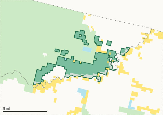
National wildlife refugeNational forestBLMODFW landState forest and trust landWenaha Wildlife AreaUnit lineLake, reservoir or riverHighway
| Size | 11,231 acres (ODFW boundary, measured) |
|---|---|
| Units | 56 Wenaha, 57 Sled Springs |
| ODFW zone | Northeast |
| First rule | Open to public access and hunting from April 1 through December 31 |
| Nearest towns | Wallowa (21 mi), Elgin (25 mi) and Lostine (28 mi) |
What are the hunting rules on Wenaha Wildlife Area?
Open to public access and hunting from April 1 through December 31. Exceptions: Year-round public access is permitted at designated camping areas, (headquarters and Griz Flat), on Department land along the Wenaha Rvr, and between the Grande Ronde Rvr Rd and the Grande Ronde Rvr from the Redmond grade bridge below Troy to the mouth of Wildcat Cr. Motorized vehicle travel restricted to open rds. Camping is restricted to areas designated for that use. Permanent Rd closure: 17 sq mi in T5 and 6N, R42 and 43E along eastern edge of Umatilla Forest in northeast corner of Wenaha Unit. Use of domestic pack goats is prohibited at all times.
ODFW's 2026 Oregon Big Game Hunting Regulations, page 89, under unit 56. ODFW 2026 Oregon Big Game Hunting Regulations.
Which hunting units is Wenaha Wildlife Area in?
Wenaha spans 2 units. ODFW's latest elk and deer harvest for the whole unit, not the wildlife area alone:
| Unit | Wildlife area acres in it | Elk harvested (unit) | Deer harvested (unit) |
|---|---|---|---|
| Unit 56 Wenaha | 11,172 | 103 (2025) | 188 (2025) |
| Unit 57 Sled Springs | 59 | 311 (2025) | 709 (2025) |
Harvest: ODFW harvest statistics (2020 to 2025). Acres in each unit measured by FilledTag from ODFW's boundaries.
How do you get to Wenaha Wildlife Area?
Highways within 8 miles: OR 3. Nearest towns: Wallowa (21 miles), Elgin (25 miles) and Lostine (28 miles).
Questions hunters ask
Can you hunt on Wenaha Wildlife Area?
ODFW's 2026 regulations set these rules for Wenaha: Open to public access and hunting from April 1 through December 31. Exceptions: Year-round public access is permitted at designated camping areas, (headquarters and Griz Flat), on Department land along the Wenaha Rvr, and between the Grande Ronde Rvr Rd and the Grande Ronde Rvr from the Redmond grade bridge below Troy to the mouth of Wildcat Cr. Hunting seasons follow the unit the ground is in.
Which unit is Wenaha Wildlife Area in?
The Wenaha Unit (56, 11,172 acres) and the Sled Springs Unit (57, 59 acres), by ODFW's boundaries.
What towns are near Wenaha Wildlife Area?
Wallowa (21 miles), Elgin (25 miles) and Lostine (28 miles), measured to the area's edge.
Get an Oregon hunt plan when they open
Hunt plans for Oregon are coming. Join the list and you'll hear first. The first 50 hunters in each new state get their plan free.
Until then, the free FilledTag app for iPhone has a map that works in every state, Oregon included.
Where these facts come from
- Rules: ODFW 2026 Oregon Big Game Hunting Regulations, page 89.
- Boundary and acres: ODFW Wildlife Areas (Compass dataset). Surrounding public land: USGS PAD-US 4.1 (fee land by manager, 2025).
- Unit harvest: ODFW harvest statistics (2020 to 2025).
FilledTag is not part of Oregon Department of Fish and Wildlife.